Dumfries e Galloway
| Dumfries e Galloway council area | |
|---|---|
| (EN) Dumfries and Galloway (GD) Dùn Phris agus an Gall-Ghaidhealaibh (SCO) Dumfries an Gallowa | |
 | |
 | |
| Localizzazione | |
| Stato | |
| Amministrazione | |
| Capoluogo | Dumfries |
| Territorio | |
| Coordinate del capoluogo | 55°04′12″N 3°36′10.8″W / 55.07°N 3.603°W |
| Superficie | 6 426,88 km² |
| Abitanti | 148 200 (2005) |
| Densità | 23,06 ab./km² |
| Altre informazioni | |
| Fuso orario | UTC+0 |
| ISO 3166-2 | GB-DGY |
| Codice ONS | 00QH |
| Cartografia | |
| |
| Sito istituzionale | |

Dumfries e Galloway (gaelico scozzese Dùn Phris agus an Gall-Ghaidhealaibh) è un'area amministrativa della Scozia.
Storia[modifica | modifica wikitesto]
La contea fu creata nell'anno 1975 dalla fusione di tre contee storiche: Dumfriesshire, Kirkcudbrightshire e Wigtownshire.
Località[modifica | modifica wikitesto]
- Ae, Airieland, Airds of Kells, Annan, Anwoth, Ardwell
- Beattock, Beeswing, Brydekirk
- Caerlaverock, Cairngaan, Cairnryan, Cargenbridge, Carsphairn, Castle Douglas, Castle Kennedy, Clarencefield, Corsock, Creetown
- Dalton, Dornock, Drumlanrig, Drummore, Dumfries, Dundrennan, Dunscore
- Eastriggs, Ecclefechan, Eskdalemuir
- Garlieston, Gatehouse of Fleet, Glenluce, Gretna Green, Gretna
- Haugh of Urr, Hoddom
- Johnstonebridge
- Keir, Kippford, Kirkcolm, Kirkcudbright
- Langholm, Lochmaben, Lockerbie
- Millhousebridge, Moffat, Moniaive, Mull of Galloway
- New Abbey, New Galloway, New Luce, Newton Stewart, Newton Wamphray
- Parton, Penpont, Portpatrick
- Robgill Tower
- Rigg, Ruthwell
- Sandhead, Sanquhar, St. John's Town of Dalry, Stranraer
- Terregles, Thornhill, Twynholm
- Wanlockhead, Whithorn, Wigtown
Infrastrutture e trasporti[modifica | modifica wikitesto]
I trasporti nella regione sono gestiti dalle compagnie di autobus Huston's, McEwan's, Stagecoach Western e McCall's coaches e dagli operatori ferroviari Abellio ScotRail, First TransPennine Express e Virgin Trains.
Ferrovie[modifica | modifica wikitesto]
La regione dispone di 7 stazioni ferroviarie; tutte sono sulla Glasgow South Western Line, tranne Lockerbie che fa parte della West Coast Main Line.
- Stranraer railway station
- Kirkconnel railway station
- Sanquhar railway station
- Dumfries railway station
- Annan railway station
- Gretna Green railway station
- Lockerbie railway station
Bus e pullman[modifica | modifica wikitesto]
La zona è servita da autobus che collegano i principali centri abitati. Servizi di autobus espressi collegano le principali città con Glasgow, Ayr, Edimburgo e Carlisle. Servizi di autobus locali sono gestiti in tutta la regione.
Mare[modifica | modifica wikitesto]
Dumfries e Galloway è sede di due porti marittimi, entrambi in servizio con l'Irlanda del Nord. Ambedue sono nella parte occidentale della regione: Stena Line e P&O Irish Sea, e hanno una porta nel villaggio di Cairnryan.
Aeroporti[modifica | modifica wikitesto]
La regione è provvista anche di aeroporti commerciali; i più vicinì sono l'aeroporto di Glasgow Prestwick e il Carlisle Lake Airport District. La regione ospita un certo numero di aeroporti privati. Nei cieli della città di Lockerbie è esploso l'aereo Pan Am 103 nell'attacco terroristico del 21 dicembre 1988.
Strade[modifica | modifica wikitesto]
Le strade principali da e verso la regione sono:
Galleria d'immagini[modifica | modifica wikitesto]
-
 Dalveen Pass.
 -

-

-
 Caerlaverock National Nature Reserve.
 -
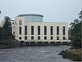 Centrale elettrica Tongland.
 -
 Promontorio del Mull of Galloway.
 -
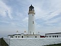 Faro del Mull of Galloway.
 -
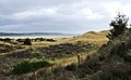
 Una delle tante spiagge nei Machars nel Wigtownshire.
 -
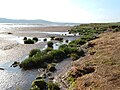
 Machars Costa guardando verso sud da Cruggleton Castle.
 -
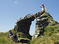 I resti del castello di Cruggleton.
 -
 The Machars con lo sfondo della Luce Bay.
 -
 Il Devil's Beef Tub.
 -

-
 Moffat.
 -
 Estuario del fiume Nith.
 -
 Broughton House, casa dell'artista E. A. Hornel.


Voci correlate[modifica | modifica wikitesto]
Altri progetti[modifica | modifica wikitesto]
 Wikimedia Commons contiene immagini o altri file su Dumfries e Galloway
 Wikivoyage contiene informazioni turistiche su Dumfries e Galloway
Collegamenti esterni[modifica | modifica wikitesto]
- Sito ufficiale, su dumgal.gov.uk.
- Dumfries and Galloway, su sapere.it, De Agostini.
- (EN) Dumfries and Galloway, su Enciclopedia Britannica, Encyclopædia Britannica, Inc.
| Controllo di autorità | VIAF (EN) 158312278 · LCCN (EN) n83053211 · J9U (EN, HE) 987007553078705171 · WorldCat Identities (EN) lccn-n83053211 |
|---|