File:MarsPanoramaa.jpg

File originale (10 000 × 1 248 pixel, dimensione del file: 11,49 MB, tipo MIME: image/jpeg)
| Questo file e la sua pagina di descrizione (discussione · modifica) si trovano su Wikimedia Commons (?) |
Dettagli
| Descrizione |
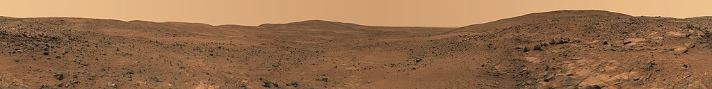
English: Descent from the Summit of 'Husband Hill'
In late November 2005 while descending "Husband Hill", NASA's Mars Exploration Rover Spirit took the most detailed panorama so far of the "Inner Basin", the rover's next target destination. Spirit acquired the 405 individual images that make up this 360-degree view of the surrounding terrain using five different filters on the panoramic camera. The rover took the images on Martian days, or sols, 672 to 677 (23 to 28 Nov. 2005). Français : Vue prise en descendant « Husband Hills », sur Mars. Panorama de 360° obtenu en assemblant 405 photos prises entre le 23 et le 28 novembre 2005 par l'astromobile Spirit de la NASA. Ce panorama est l'image la plus précise de l'« Inner Bassin ». On peut voir en explorant ce panorama en détail les pistes tracées par Spirit lors de son ascension de la colline. |
| Data | Nov. 23-28, 2005 |
| Fonte | NASA Jet Propulsion Laboratory[1] |
| Autore | NASA |
| Altre versioni | Restored version of Image:MarsPanorama.jpg with cropping to remove blank patches and minor changes to address stitching flaws. |
| 360° | Visualizza l'immagine panoramica a 360°
|
|---|
|

Questa immagine è stata selezionata come Immagine del giorno in data 12 gennaio 2011. La didascalia era la seguente: Italiano: Discesa dalla sommità della collina Husband Hill su Marte ripresa dal rover Spirit durante la sua missione nel 2005. Altre lingue:
Dansk: Nedkørsel fra toppen af "Husband Hill", en af Columbia-bakkerne i Gusevkrateret i Aeolis quadranglen (180-225° V, 0-30° S) på Mars. Optaget af den ubemandede rumsonde Spirit (en MER) fra 23.-28. november 2005 (Mars soltid, dag 672-677). English: Descent from the Summit of 'Husband Hill', panorama by Spirit Rover taken in 2005. Español: Descenso desde la cima de Husband Hill. Panorámica tomada por el Spirit a finales de noviembre de 2005 en Marte. Italiano: Discesa dalla sommità della collina Husband Hill su Marte ripresa dal rover Spirit durante la sua missione nel 2005. Magyar: Marsi tájkép a Husband Hill-ről nézve Nederlands: Afdaling van de kruin van de Husband Hill, een van de Columbia Hills in de Gusevkrater in het Aeolis-quadrangle (180-225° W, 0-30° Z) van Mars. Panorama gemaakt door het onbemande ruimtevaartuig Spirit (een MER) op 23 tot 28 november 2005 (sol/Martiaanse zonnedag 672 tot 677). Українська: Кругова панорама з вершини Пагорба Хазбенд на Марсі, світлини зроблені марсоходом «Спірит» 23 - 28 листопада 2005 р. 日本語: 火星のハズバンド・ヒル頂上からの下り坂。無人探査機スピリットによる撮影。 |
Licenza
| Questo file è nel pubblico dominio perché creato dalla NASA. La politica sul copyright della NASA afferma che «il materiale della NASA non è protetto da copyright a meno che non sia specificato altrimenti». (NASA copyright policy e JPL Image Use Policy). | ||
 |
Attenzione:
|
Cronologia del file
Fare clic su un gruppo data/ora per vedere il file come si presentava nel momento indicato.
| Data/Ora | Miniatura | Dimensioni | Utente | Commento | |
|---|---|---|---|---|---|
| attuale | 08:40, 1 mar 2008 | 10 000 × 1 248 (11,49 MB) | Durova | {{Information |Description= |Source= |Date= |Author= |Permission= |other_versions= }} | |
| 08:27, 1 mar 2008 | 7 000 × 874 (5,9 MB) | Durova | {{Information |Description= |Source=self-made |Date= |Author= Durova |Permission= |other_versions= }} | ||
| 08:00, 1 mar 2008 | 5 500 × 686 (2,1 MB) | Durova | {{Information |Description=Descent from the Summit of 'Husband Hill' In late November 2005 while descending "Husband Hill," NASA's Mars Exploration Rover Spirit took the most detailed panorama so far of the "Inner Basin," the rover's next target destinat |
Pagine che usano questo file
Le seguenti 2 pagine usano questo file:
Utilizzo globale del file
Anche i seguenti wiki usano questo file:
- Usato nelle seguenti pagine di ar.wikipedia.org:
- Usato nelle seguenti pagine di ba.wikipedia.org:
- Usato nelle seguenti pagine di be-tarask.wikipedia.org:
- Usato nelle seguenti pagine di be.wikipedia.org:
- Usato nelle seguenti pagine di bg.wikipedia.org:
- Usato nelle seguenti pagine di bn.wikipedia.org:
- Usato nelle seguenti pagine di crh.wikipedia.org:
- Usato nelle seguenti pagine di cv.wikipedia.org:
- Usato nelle seguenti pagine di da.wikipedia.org:
- Usato nelle seguenti pagine di en.wikipedia.org:
- Mars rover
- Husband Hill
- User:Kotra
- Portal:Outer space
- Portal:Solar System
- Portal:Solar System/Selected picture
- User:Darkieboy236
- Wikipedia:WikiProject Media Restoration/Landmark images
- Wikipedia:Featured pictures thumbs/10
- Wikipedia:Featured picture candidates/March-2008
- Wikipedia:Featured picture candidates/Mars panorama
- Wikipedia:Wikipedia Signpost/2008-03-13/Features and admins
- User talk:Durova/Archive 53
- User:Orion11M87
- Wikipedia:Picture of the day/September 2008
- Template:POTD/2008-09-12
- Wikipedia:Wikipedia Signpost/2008-03-13/SPV
- User talk:Durova/Archive 62
- User:Durova/Featured credits at the Turkish language Wikipedia
- User:Darkieboy236/Sandbox
- User:Durova/Featured picture gallery/2008
- Portal:Outer space/Selected picture
- Portal:Outer space/Selected picture/28
- Wikipedia:Featured pictures/Space/Panorama
- Wikipedia:Wikipedia Signpost/Single/2008-03-13
- Usato nelle seguenti pagine di en.wikiversity.org:
- Usato nelle seguenti pagine di es.wikipedia.org:
- Usato nelle seguenti pagine di fa.wikipedia.org:
- Usato nelle seguenti pagine di fr.wikipedia.org:
- Usato nelle seguenti pagine di hu.wikipedia.org:
Visualizza l'utilizzo globale di questo file.