File:Taupo.Volcanic.Zone.North.Island.NZ.JPG
File originale (616 × 864 pixel, dimensione del file: 104 KB, tipo MIME: image/jpeg)
| Questo file e la sua pagina di descrizione (discussione · modifica) si trovano su Wikimedia Commons (?) |
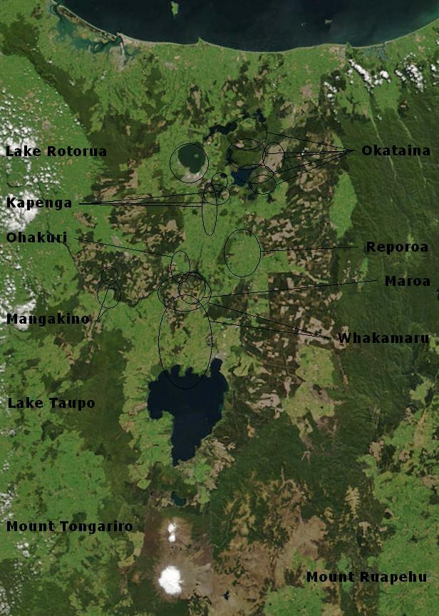
| Descrizione | Bay of Plenty, North Island, New Zealand, from the Bay of Plenty coast to Mounts Tongariro, Ngauruhoe, and Ruapehu (at bottom of picture). Also shows Lake Taupo and the Rotorua Lakes. This scene was acquired by the Moderate Resolution Imaging Spectroradiometer (MODIS), flying aboard NASA’s Terra satellite, on October 23, 2002 |
| Data | (UTC) |
| Fonte | |
| Autore |
|
Annotations based on: Hiess J, Cole JW, Spinks KD (2007), High-Alumina Basalts of the Taupo Volcanic Zone, New Zealand: Influence of the Crust and Crustal Structure [1]; Krippner SJP, Briggs RM, Wilson CJN, Cole JW (1998), Petrography and geochemistry of lithic fragments in ignimbrites from the Mangakino Volcanic Centre: implications for the composition of the subvolcanic crust in western Taupo Volcanic Zone, New Zealand; New Zealand Journal of Geology and Geophysics, Vol. 41: 187-199 [2] copia archiviata at the Wayback Machine; Newhall, Christopher G.; Dzurisin, Daniel (1988), Historical unrest at large calderas of the world, USGS Bulletin 1855, p. 1108 [3] copia archiviata at the Wayback Machine; Siebert L, Simkin T (2002-), Volcanoes of the World: an Illustrated Catalog of Holocene Volcanoes and their Eruptions, Smithsonian Institution, Global Volcanism Program Digital Information Series, GVP-3 [4]
| Questo file è nel pubblico dominio perché creato dalla NASA. La politica sul copyright della NASA afferma che «il materiale della NASA non è protetto da copyright a meno che non sia specificato altrimenti». (NASA copyright policy e JPL Image Use Policy). | ||
 |
Attenzione:
|
Registro originale del caricamento
This image is a derivative work of the following images:
- File:BayofPlentyA2002296.jpg licensed with PD-USGov-NASA
- 2007-08-24T00:20:45Z Kahuroa 616x864 (505144 Bytes) == Summary == {{Information |Description=Bay of Plenty, North Island, New Zealand, from the Bay of Plenty coast to Mounts Tongariro, Ngauruhoe, and Ruapehu (at bottom of picture). Also shows Lake Taupo and the Rotorua Lakes.
Uploaded with derivativeFX
Cronologia del file
Fare clic su un gruppo data/ora per vedere il file come si presentava nel momento indicato.
| Data/Ora | Miniatura | Dimensioni | Utente | Commento | |
|---|---|---|---|---|---|
| attuale | 04:17, 20 feb 2010 | | 616 × 864 (104 KB) | Chris.urs-o | One label was missing. |
| 03:49, 20 feb 2010 |  | 616 × 864 (103 KB) | Chris.urs-o | Fixed label | |
| 12:42, 19 feb 2010 |  | 616 × 864 (105 KB) | Chris.urs-o | Improved caldera locations | |
| 13:20, 18 feb 2010 |  | 616 × 864 (103 KB) | Chris.urs-o | {{Information |Description=Bay of Plenty, North Island, New Zealand, from the Bay of Plenty coast to Mounts Tongariro, Ngauruhoe, and Ruapehu (at bottom of picture). Also shows Lake Taupo and the Rotorua Lakes. This scene was acquired by the Moderate Reso |
Pagine che usano questo file
La seguente pagina usa questo file:
Utilizzo globale del file
Anche i seguenti wiki usano questo file:
- Usato nelle seguenti pagine di ar.wikipedia.org:
- Usato nelle seguenti pagine di de.wikipedia.org:
- Usato nelle seguenti pagine di en.wikipedia.org:
- Usato nelle seguenti pagine di en.wikiversity.org:
- Usato nelle seguenti pagine di es.wikipedia.org:
- Usato nelle seguenti pagine di fi.wikipedia.org:
- Usato nelle seguenti pagine di id.wikipedia.org:
- Usato nelle seguenti pagine di mk.wikipedia.org:
- Usato nelle seguenti pagine di ru.wikipedia.org:
- Usato nelle seguenti pagine di simple.wikipedia.org:
- Usato nelle seguenti pagine di sl.wikipedia.org:
- Usato nelle seguenti pagine di uk.wikipedia.org: