File:Schlieffen Plan.jpg

File originale (963 × 745 pixel, dimensione del file: 732 KB, tipo MIME: image/jpeg)
| Questo file e la sua pagina di descrizione (discussione · modifica) si trovano su Wikimedia Commons (?) |

|
File:Schlieffen Plan fr.svg è una versione vettoriale di questo file. Dovrebbe essere usata quella versione al posto di questo file JPG, quando sia migliore.
File:Schlieffen Plan.jpg → File:Schlieffen Plan fr.svg
Per maggiori informazioni, vedi Help:SVG. |
 |
| Descrizione |
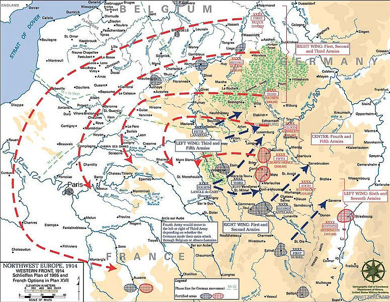
English: Schlieffen Plan
In 1938 the predecessors of what is today The Department of History at the United States Military Academy began developing a series of campaign atlases to aid in teaching cadets a course entitled, "History of the Military Art." Since then, the Department has produced over six atlases and more than one thousand maps, encompassing not only America’s wars but global conflicts as well. In keeping abreast with today's technology, the Department of History is providing these maps on the internet as part of the department's outreach program. The maps were created by the United States Military Academy’s Department of History and are the digital versions from the atlases printed by the United States Defense Printing Agency. We gratefully acknowledge the accomplishments of the department's former cartographer, Mr. Edward J. Krasnoborski, along with the works of our present cartographer, Mr. Frank Martini. Please be aware that these maps are large in file size and may require substantial download times. |
| Data | 05/09/2008 |
| Fonte | Westpoint.edu, WWI Atlas, Shlieffen Plan |
| Autore | Tinodela |
| Altre versioni |
|
Questo file multimediale è stato realizzato da un soldato o da un dipendente dell'Esercito degli Stati Uniti durante il suo servizio. Essendo un'opera del governo federale statunitense, il file è nel pubblico dominio.
|
 |
Derivative works
Opere derivate da questo file: Schlieffen Plan.svg
Cronologia del file
Fare clic su un gruppo data/ora per vedere il file come si presentava nel momento indicato.
| Data/Ora | Miniatura | Dimensioni | Utente | Commento | |
|---|---|---|---|---|---|
| attuale | 13:43, 23 lug 2012 | | 963 × 745 (732 KB) | Soerfm | Paris |
| 13:58, 1 mar 2006 |  | 969 × 751 (273 KB) | W.wolny |
Pagine che usano questo file
Le seguenti 3 pagine usano questo file:
Utilizzo globale del file
Anche i seguenti wiki usano questo file:
- Usato nelle seguenti pagine di ar.wikipedia.org:
- Usato nelle seguenti pagine di be-tarask.wikipedia.org:
- Usato nelle seguenti pagine di be.wikipedia.org:
- Usato nelle seguenti pagine di bg.wikipedia.org:
- Usato nelle seguenti pagine di ca.wikipedia.org:
- Usato nelle seguenti pagine di cs.wikipedia.org:
- Usato nelle seguenti pagine di da.wikipedia.org:
- Usato nelle seguenti pagine di de.wikipedia.org:
- Usato nelle seguenti pagine di de.wikibooks.org:
- Usato nelle seguenti pagine di de.wikinews.org:
- Usato nelle seguenti pagine di el.wikipedia.org:
- Usato nelle seguenti pagine di en.wikipedia.org:
- Usato nelle seguenti pagine di en.wikibooks.org:
- Usato nelle seguenti pagine di fi.wikipedia.org:
- Usato nelle seguenti pagine di fr.wikipedia.org:
Visualizza l'utilizzo globale di questo file.