File:Sault Ste Marie, Ontario and Michigan.JPG
Vai alla navigazione
Vai alla ricerca

Dimensioni di questa anteprima: 398 × 599 pixel. Altre risoluzioni: 159 × 240 pixel | 319 × 480 pixel | 510 × 768 pixel | 680 × 1 024 pixel | 1 360 × 2 048 pixel | 2 848 × 4 288 pixel.
File originale (2 848 × 4 288 pixel, dimensione del file: 8,47 MB, tipo MIME: image/jpeg)
| Questo file e la sua pagina di descrizione (discussione · modifica) si trovano su Wikimedia Commons (?) |
Dettagli
| Descrizione |
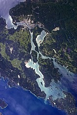
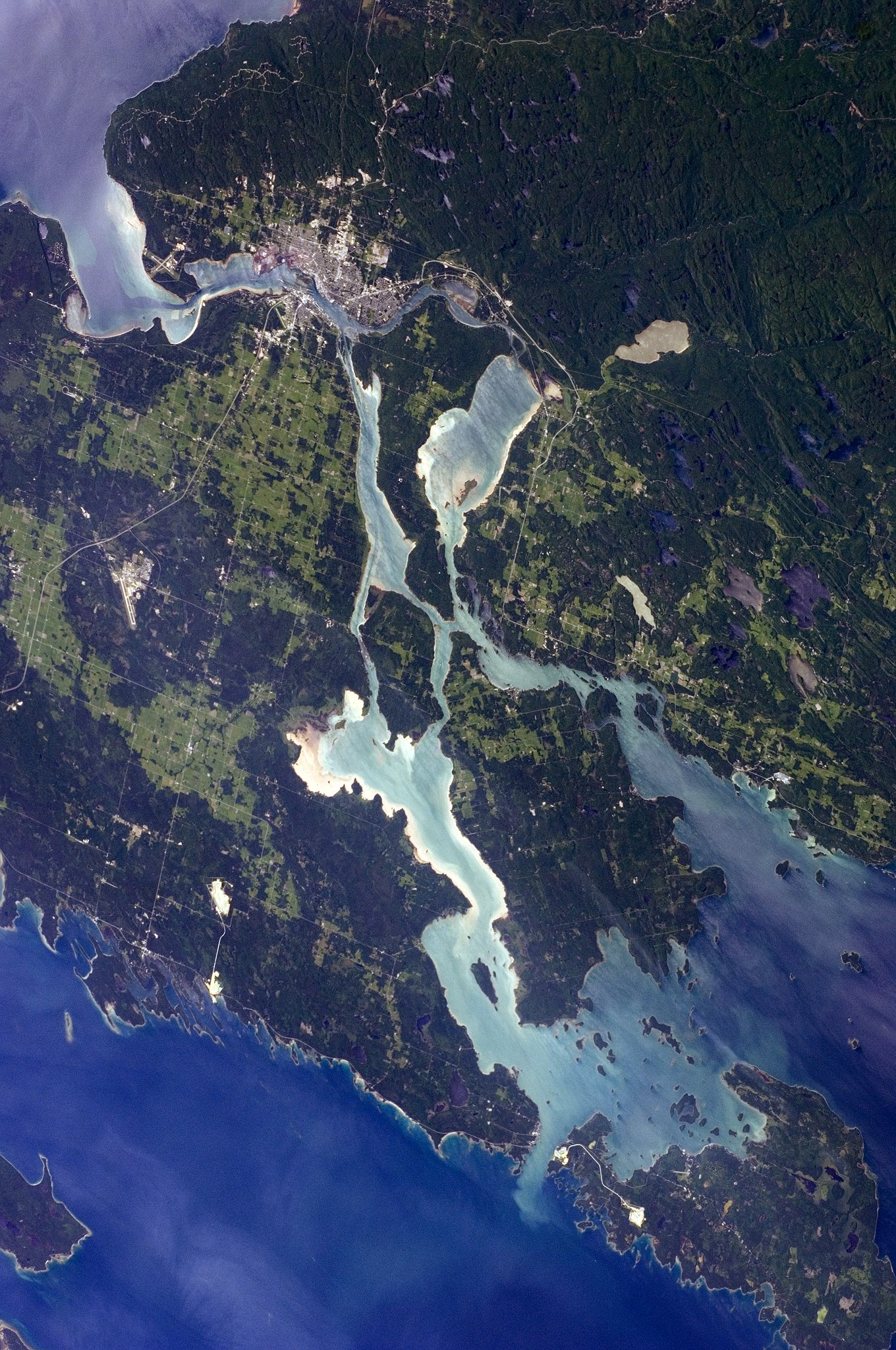
English: The twin cities of Sault Ste Marie are located across the St. Mary’s River, which forms part of the international boundary between Canada (Province of Ontario) and the United States (State of Michigan). This astronaut photograph highlights the two cities, as well as the lakes and islands that separate Lakes Huron and Superior, two of the Great Lakes of North America. Smaller lakes include Lake George to the west, and the large forested islands of St. Joseph and Drummond are visible at image upper left.
The Sault Ste Marie urban areas (image lower left) have a distinctive gray to white colour, contrasting with the deep green of forested areas in Ontario and the lighter green of agricultural fields in Michigan. The water surfaces in the lakes and rivers vary from blue to blue-green to silver, likely the result of varying degrees of sediment and sunglint—light reflecting from the water surface back to the International Space Station. |
| Data | |
| Fonte | NASA Earth Observatory |
| Autore | ISS Expedition 28 crew |
| Luogo dello scatto | | Posizione di questa e altre immagini su: OpenStreetMap |
|---|
Questa immagine o filmato è stato catalogato dal Johnson Space Center della National Aeronautics and Space Administration (NASA) degli Stati Uniti d'Americacon il Photo ID: ISS028-E-10162.Questo tag non indica lo status del copyright dell'opera ad esso associato. È quindi richiesto un normale tag di copyright. Vedi Commons:Licenze per maggiori informazioni. Altre lingue:
|
Image acquired with a Nikon D2Xs digital camera using a 110 mm lens, and is provided by the ISS Crew Earth Observations experiment and Image Science & Analysis Laboratory, Johnson Space Center.
Licenza
| Questo file è nel pubblico dominio perché creato dalla NASA. La politica sul copyright della NASA afferma che «il materiale della NASA non è protetto da copyright a meno che non sia specificato altrimenti». (NASA copyright policy e JPL Image Use Policy). | ||
 |
Attenzione:
|
| Annotazioni | Questa immagine è annotata: Vedi le annotazioni su Commons |
Cronologia del file
Fare clic su un gruppo data/ora per vedere il file come si presentava nel momento indicato.
| Data/Ora | Miniatura | Dimensioni | Utente | Commento | |
|---|---|---|---|---|---|
| attuale | 14:12, 18 ago 2018 | | 2 848 × 4 288 (8,47 MB) | Ras67 | new rendered from NASA's raw image date with real quality and without clipped highlights |
| 22:48, 23 feb 2013 |  | 2 848 × 4 288 (12,03 MB) | Rotatebot | Bot: Image rotated by 90° | |
| 14:20, 11 lug 2011 |  | 4 288 × 2 848 (10,92 MB) | Originalwana | {{Information |Description ={{en|1=The twin cities of Sault Ste Marie are located across the St. Mary’s River, which forms part of the international boundary between Canada (Province of Ontario) and the United S |
Pagine che usano questo file
La seguente pagina usa questo file:
Utilizzo globale del file
Anche i seguenti wiki usano questo file:
- Usato nelle seguenti pagine di ar.wikipedia.org:
- Usato nelle seguenti pagine di el.wikipedia.org:
- Usato nelle seguenti pagine di en.wikipedia.org:
- Usato nelle seguenti pagine di et.wikipedia.org:
- Usato nelle seguenti pagine di fa.wikipedia.org:
- Usato nelle seguenti pagine di fi.wikipedia.org:
- Usato nelle seguenti pagine di nl.wikipedia.org: