File:SIR-B Sudbury Impact Crater.jpg
SIR-B_Sudbury_Impact_Crater.jpg (432 × 249 pixel, dimensione del file: 87 KB, tipo MIME: image/jpeg)
| Questo file e la sua pagina di descrizione (discussione · modifica) si trovano su Wikimedia Commons (?) |
Dettagli
| Descrizione |
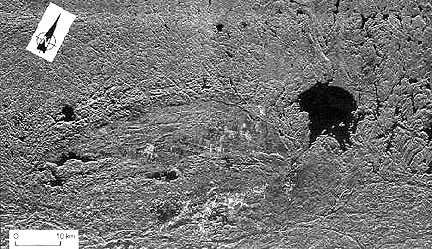
English: A SIR-B radar image of southern Ontario highlights two juxtaposed but unrelated craters that are very different in age, in size, and in structural state.
SIR-B radar image of the Sudbury impact structure (elliptical because of deformation by Grenville thrusting) and the nearby Wanapitei crater (lake-filled) formed much later. The partially circular lake-filled structure on the right (east) is the 8 km (5 mi) wide Wanapitei crater, estimated to have formed 34 million years (m.y.) ago. The far larger Sudbury structure (second largest on Earth) appears as a pronounced elliptical pattern, more strongly expressed by the low hills to the north. This huge impact crater, with its distinctive outline, was created about 1800 m.y. ago. Some scientists argue that it was at least 245 km (152 mi) across when it was circular. More than 900 m.y. later strong northwestward thrusting of the Grenville Province terrane against the Superior Province (containing Sudbury) subsequently deformed it into its present elliptical shape (geologists will recognize this as a prime example of the "strain ellipsoid" model). After Sudbury was initially excavated, magmas from deep in the crust invaded the breccia filling, mixing with it and forming a boundary layer against its walls. Some investigators think that the resulting norite rocks are actually melted target rocks. This igneous rock (called an "irruptive") is host to vast deposits of nickel and copper, making this impact structure a 5 billion dollar source of ore minerals since mining began in the last century. Further information found here: http://www.data.gov/geodata/g599452, Full credits here: http://www.geodata.gov/E-FW/DiscoveryServlet?uuid={31FB4C05-E523-8C6C-CD83-41E4435A90FE}&xmltransform=metadata_details.xsl, Shuttle mission data here: http://southport.jpl.nasa.gov/scienceapps/sirb.htmlFrançais : Image prise sur la navette spatiale Challenger en 1984 du Bassin de Sudbury. Le lac Wanapitei en haut à droite est un cratère d'impact plus jeune que le Bassin. Riche en minerais, plusieurs mines se trouvent dans le bassin, notamment des mines de nickel et de cuivre. |
| Data | SIR-B was launched on October 5, 1984 aboard the Space Shuttle Challenger on flight 41-G |
| Fonte | http://rst.gsfc.nasa.gov/Sect18/Sect18_5.html |
| Autore | Astronauts on Space Shuttle Challenger on flight 41-G |
| Altre versioni | Taken from: http://rst.gsfc.nasa.gov/Sect18/Sect18_5.html |
Licenza
| Questo file è nel pubblico dominio perché creato dalla NASA. La politica sul copyright della NASA afferma che «il materiale della NASA non è protetto da copyright a meno che non sia specificato altrimenti». (NASA copyright policy e JPL Image Use Policy). | ||
 |
Attenzione:
|
Cronologia del file
Fare clic su un gruppo data/ora per vedere il file come si presentava nel momento indicato.
| Data/Ora | Miniatura | Dimensioni | Utente | Commento | |
|---|---|---|---|---|---|
| attuale | 21:46, 2 gen 2017 | | 432 × 249 (87 KB) | Quibik | desaturate since it is a single-band image |
| 06:09, 14 giu 2011 |  | 432 × 249 (92 KB) | Oaktree b | {{Information |Description ={{en|1=A SIR-B radar image of southern Ontario highlights two juxtaposed but unrelated craters that are very different in age, in size, and in structural state. SIR-B radar image of the Sudbury impact structure (elliptical |
Pagine che usano questo file
La seguente pagina usa questo file:
Utilizzo globale del file
Anche i seguenti wiki usano questo file:
- Usato nelle seguenti pagine di bg.wikipedia.org:
- Usato nelle seguenti pagine di en.wikipedia.org:
- Usato nelle seguenti pagine di en.wikiversity.org:
- Usato nelle seguenti pagine di fi.wikipedia.org:
- Usato nelle seguenti pagine di fr.wikipedia.org:
- Usato nelle seguenti pagine di he.wikipedia.org:
- Usato nelle seguenti pagine di ja.wikipedia.org:
- Usato nelle seguenti pagine di pl.wikipedia.org:
- Usato nelle seguenti pagine di ru.wikipedia.org:
- Usato nelle seguenti pagine di simple.wikipedia.org:
- Usato nelle seguenti pagine di zh.wikipedia.org: