File:PIA16710-MarsMcLaughlinCrater-MRO-HiRISE-20130120.jpg

PIA16710-MarsMcLaughlinCrater-MRO-HiRISE-20130120.jpg (612 × 431 pixel, dimensione del file: 44 KB, tipo MIME: image/jpeg)
| Questo file e la sua pagina di descrizione (discussione · modifica) si trovano su Wikimedia Commons (?) |
Dettagli
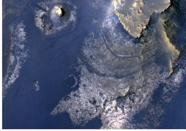
| Descrizione |
English: PIA16710: Layers with Carbonate Content Inside McLaughlin Crater on Mars
http://photojournal.jpl.nasa.gov/catalog/?IDNumber=pia16710 Target Name: Mars Is a satellite of: Sol (our sun) Mission: Mars Reconnaissance Orbiter (MRO) Spacecraft: Mars Reconnaissance Orbiter (MRO) Instrument: HiRISE Product Size: 612 x 431 pixels (width x height) Produced By: University of Arizona/HiRise-LPL Full-Res TIFF: PIA16710.tif (791.8 kB) Full-Res JPEG: PIA16710.jpg (45.18 kB) Click on the image above to download a moderately sized image in JPEG format (possibly reduced in size from original) Original Caption Released with Image: Figure 1 Click on the image for larger version This view of layered rocks on the floor of McLaughlin Crater shows sedimentary rocks that contain spectroscopic evidence for minerals formed through interaction with water. The High Resolution Imaging Science Experiment (HiRISE) camera on NASA's Mars Reconnaissance Orbiter recorded the image. A combination of clues suggests this 1.4-mile-deep (2.2-kilometer-deep) crater once held a lake fed by groundwater. Part of the evidence is identification of clay and carbonate minerals within layers visible near the center of this image. The mineral identifications come from the Compact Reconnaissance Imaging Spectrometer for Mars (CRISM), also on the Mars Reconnaissance Orbiter. The scene covers an area about one-third of a mile (about 550 meters) across, at 337.6 degrees east longitude, 21.9 degrees north latitude. North is up. Figure 1 indicates the location of layers bearing clay and carbonate minerals and includes a scale bar of 100 meters (328 feet). HiRISE is one of six instruments on NASA's Mars Reconnaissance Orbiter. The University of Arizona, Tucson, operates the orbiter's HiRISE camera, which was built by Ball Aerospace & Technologies Corp., Boulder, Colo. NASA's Jet Propulsion Laboratory, a division of the California Institute of Technology in Pasadena, manages the Mars Reconnaissance Orbiter Project for NASA's Science Mission Directorate, Washington. Lockheed Martin Space Systems, Denver, built the spacecraft. Image Credit: NASA/JPL-Caltech/Univ. of Arizona Image Addition Date: 2013-01-20 |
| Data | |
| Fonte | http://photojournal.jpl.nasa.gov/jpeg/PIA16710.jpg |
| Autore | NASA/JPL-Caltech/Univ. of Arizona |
Licenza
| Questo file è nel pubblico dominio perché creato dalla NASA. La politica sul copyright della NASA afferma che «il materiale della NASA non è protetto da copyright a meno che non sia specificato altrimenti». (NASA copyright policy e JPL Image Use Policy). | ||
 |
Attenzione:
|
Cronologia del file
Fare clic su un gruppo data/ora per vedere il file come si presentava nel momento indicato.
| Data/Ora | Miniatura | Dimensioni | Utente | Commento | |
|---|---|---|---|---|---|
| attuale | 21:10, 21 gen 2013 | | 612 × 431 (44 KB) | Drbogdan | User created page with UploadWizard |
Pagine che usano questo file
Le seguenti 2 pagine usano questo file:
Utilizzo globale del file
Anche i seguenti wiki usano questo file:
- Usato nelle seguenti pagine di beta.wikiversity.org:
- Usato nelle seguenti pagine di en.wikipedia.org:
- Usato nelle seguenti pagine di en.wikiversity.org:
- Usato nelle seguenti pagine di es.wikipedia.org:
- Usato nelle seguenti pagine di uk.wikipedia.org:
- Usato nelle seguenti pagine di www.wikidata.org:
- Usato nelle seguenti pagine di zh.wikipedia.org: