File:Burmese-Siamese war (1765-1767) map - EN - 001.jpg
Vai alla navigazione
Vai alla ricerca

Dimensioni di questa anteprima: 342 × 599 pixel. Altre risoluzioni: 137 × 240 pixel | 274 × 480 pixel | 438 × 768 pixel | 584 × 1 024 pixel | 1 516 × 2 657 pixel.
File originale (1 516 × 2 657 pixel, dimensione del file: 461 KB, tipo MIME: image/jpeg)
| Questo file e la sua pagina di descrizione (discussione · modifica) si trovano su Wikimedia Commons (?) |
Dettagli
| Descrizione |
English:
ไทย:
|
| Data | |
| Fonte |
Opera propria
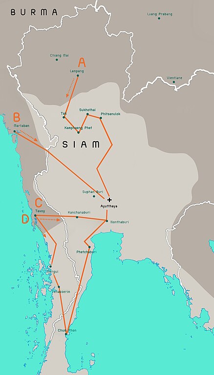
Terwiel, Bertrand. Thailand's Political History: From the 13th Century to Recent Times. Approximate boundaries of the six states that formed after Ayutthaya's destruction. |
| Autore | Aristitleism |
| Altre versioni |
_map_-_TH_-_002.jpg) |
Licenza
Io, detentore del copyright su quest'opera, dichiaro di pubblicarla con la seguente licenza:
| Questo file è reso disponibile nei termini della licenza Creative Commons CC0 1.0 Universal. | |
| La persona che ha associato un'opera con questo atto legale ha donato tale opera nel pubblico dominio rinunciando a tutti i diritti sull'opera in tutto il mondo, inclusi tutti i diritti connessi o altri diritti simili, per quanto permesso dalla legge. Puoi copiare, modificare, distribuire ed utilizzare l'opera, anche a fini commerciali, senza chiedere alcun permesso.
|
en:Burmese–Siamese War (1765–1767)

|
Questa immagine (categorizzazione automatica: historical map) o tutte le immagini in questa categoria o galleria dovrebbero essere ricreate usando grafica vettoriale come file SVG. Questo offre diversi vantaggi: vedi Commons:Media for cleanup per maggiori informazioni. Se è disponibile una versione in formato SVG di questa immagine, per favore caricala. Dopo aver caricato un file SVG, sostituisci questo avviso con il template {{Vector version available|nome_immagine.svg}}.
|


_map_-_EN_-_001.jpg?uselang=it)
_map_-_EN_-_001.jpg)
_map_-_EN_-_001.jpg&action=edit)
Cronologia del file
Fare clic su un gruppo data/ora per vedere il file come si presentava nel momento indicato.
_map_-_EN_-_001.jpg&dir=prev)
_map_-_EN_-_001.jpg&offset=20110724171301)
_map_-_EN_-_001.jpg&offset=&limit=20)
_map_-_EN_-_001.jpg&offset=&limit=50)
_map_-_EN_-_001.jpg&offset=&limit=100)
_map_-_EN_-_001.jpg&offset=&limit=250)
_map_-_EN_-_001.jpg&offset=&limit=500)
| Data/Ora | Miniatura | Dimensioni | Utente | Commento | |
|---|---|---|---|---|---|
| attuale | 10:29, 19 lug 2023 | | 1 516 × 2 657 (461 KB) | Yourlocallordandsavior | Based off the Siamese civil war borders from Terwiel's "Thailand's Political History: From the 13th Century to Recent Times". |
| 10:51, 12 lug 2023 |  | 1 516 × 2 657 (464 KB) | Yourlocallordandsavior | Major updated borders (riverine and land). | |
| 05:40, 3 mar 2023 |  | 1 516 × 2 657 (402 KB) | Yourlocallordandsavior | Added Phetchabun according to 17th century urban places map in "A History of Ayutthaya" by Baker and Phongpaichit. | |
| 06:45, 19 feb 2023 |  | 1 516 × 2 657 (403 KB) | Yourlocallordandsavior | Added Phimai, Phimai was where Prince Thepphiphit had his seat of power in the 1767-71 civil war. | |
| 04:46, 19 feb 2023 |  | 1 516 × 2 657 (404 KB) | Yourlocallordandsavior | . | |
| 03:27, 19 feb 2023 |  | 1 516 × 2 657 (406 KB) | Yourlocallordandsavior | Removed the Forest Mueang and adjusted borders. | |
| 19:23, 19 ago 2011 |  | 1 516 × 2 657 (1,05 MB) | Tiemianwusi | Changing the colour of the third territories (from pale blue to pale taupe) | |
| 17:47, 19 ago 2011 |  | 1 516 × 2 657 (1,05 MB) | Tiemianwusi | (1) Correcting boundaries, (2) Darker Burmese territories, (3) Recolouring third territories, (4) Correcting advance routes. | |
| 10:47, 25 lug 2011 |  | 1 516 × 2 657 (1,05 MB) | Tiemianwusi | "Margui" → "Mergui" | |
| 19:13, 24 lug 2011 |  | 1 516 × 2 657 (1,05 MB) | Tiemianwusi | Correcting territories |
Pagine che usano questo file
Le seguenti 4 pagine usano questo file:
Utilizzo globale del file
Anche i seguenti wiki usano questo file:
- Usato nelle seguenti pagine di ar.wikipedia.org:
- Usato nelle seguenti pagine di en.wikipedia.org:
- Usato nelle seguenti pagine di es.wikipedia.org:
- Usato nelle seguenti pagine di km.wikipedia.org:
- Usato nelle seguenti pagine di my.wikipedia.org:
- Usato nelle seguenti pagine di uk.wikipedia.org:
- Usato nelle seguenti pagine di vi.wikipedia.org:
- Usato nelle seguenti pagine di www.wikidata.org:
- Usato nelle seguenti pagine di zh.wikipedia.org:
_map_-_EN_-_001.jpg)