File:Basin of Lop Nur 90.25E, 40.10N, Desert of Lop, Kum Tagh and Astin Tagh.jpg
Vai alla navigazione
Vai alla ricerca

Dimensioni di questa anteprima: 800 × 520 pixel. Altre risoluzioni: 320 × 208 pixel | 640 × 416 pixel | 1 024 × 666 pixel | 1 280 × 832 pixel | 2 539 × 1 651 pixel.
File originale (2 539 × 1 651 pixel, dimensione del file: 2,5 MB, tipo MIME: image/jpeg)
| Questo file e la sua pagina di descrizione (discussione · modifica) si trovano su Wikimedia Commons (?) |
Dettagli
| Descrizione |
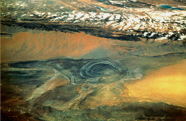
English: China, Xinjiang, desert Lop Nur. Satellite picture of the Basin of the formerly sea Lop Nur in the Desert of Lop. In the foreground Kuruktagh, in the background Kumtagh and Astintagh. A duststorm is blowing to the west over the Desert of Lop. Two lakes appear in a break in the clouds covering the Plateau of Astintagh. Visible are elongated Ayakkum Hu Lake south-southwest of Lop Nur and small blue-green Gas Hu Lake.
Deutsch: China, Xinjiang, Wüste Lop Nor. Satellitenaufnahme von dem mittleren Teil des Seebeckens Lop Nor und der Wüste Lop Nor, über die ein Sandsturm hinweggeht. Im Vordergrund sieht man die Hänge des Gebirges Kuruktagh, im Hintergrund die Hänge des Kumtagh und die Hochebene des Astintagh, auf der rechts der See Ayakkum Hu und links der kleinere See Gas Hu liegen. Blick von Norden Richtung Süden. |
| Data | |
| Fonte | NASA Mission: STS047, Roll-Frame 151 – 26, File name STS047-151-26.JPG. [1]. See also: [2]. |
| Autore |
English: NASA. Image courtesy of Earth Sciences and Image Analysis Laboratory, NASA Johnson Space Center. Color adjusting of this image (using Adobe Photoshop 6.0): Michael Gaebler, 02. March 2006, own work, all rights released (Public domain).
Deutsch: Zugrunde liegt ein noch nicht farbrichtiges Astronauten-Foto der NASA. Diese Fotografie wurde von Michael Gaebler am 02. März 2006 im RGB-Modus mit Adobe Photoshop 6.0 mit Farb- und Tonwertkorrekturen überarbeitet. |
| Licenza (Riusare questo file) |
PD-USGov-NASA |
![[1]](ftp://eol.jsc.nasa.gov/EFS_highres_STS047_STS047-151-26.JPG)
Questa immagine o filmato è stato catalogato da uno dei centri della National Aeronautics and Space Administration (NASA) degli Stati Uniti d'Americacon il Photo ID: STS047-151-26.Questo tag non indica lo status del copyright dell'opera ad esso associato. È quindi richiesto un normale tag di copyright. Vedi Commons:Licenze per maggiori informazioni. Altre lingue:
|
Licenza
| Questo file è nel pubblico dominio perché creato dalla NASA. La politica sul copyright della NASA afferma che «il materiale della NASA non è protetto da copyright a meno che non sia specificato altrimenti». (NASA copyright policy e JPL Image Use Policy). | ||
 |
Attenzione:
|
Cronologia del file
Fare clic su un gruppo data/ora per vedere il file come si presentava nel momento indicato.
| Data/Ora | Miniatura | Dimensioni | Utente | Commento | |
|---|---|---|---|---|---|
| attuale | 00:46, 11 mar 2006 | | 2 539 × 1 651 (2,5 MB) | Michael Gäbler | {{Information| |Description = en: China, Xinjiang, desert Lop Nur. Satellite picture of the Basin of the formerly sea Lop Nur in the Desert of Lop. In the foreground Kuruktagh, in the background Kumtagh and Astintagh. A duststorm is blowing to th |
Pagine che usano questo file
Le seguenti 2 pagine usano questo file:
Utilizzo globale del file
Anche i seguenti wiki usano questo file:
- Usato nelle seguenti pagine di az.wikipedia.org:
- Usato nelle seguenti pagine di de.wikipedia.org:
- Usato nelle seguenti pagine di en.wikipedia.org:
- Usato nelle seguenti pagine di en.wikibooks.org:
- Usato nelle seguenti pagine di es.wikipedia.org:
- Usato nelle seguenti pagine di fa.wikipedia.org:
- Usato nelle seguenti pagine di frr.wikipedia.org:
- Usato nelle seguenti pagine di he.wikivoyage.org:
- Usato nelle seguenti pagine di hi.wikipedia.org:
- Usato nelle seguenti pagine di id.wikipedia.org:
- Usato nelle seguenti pagine di ja.wikipedia.org:
- Usato nelle seguenti pagine di ka.wikipedia.org:
- Usato nelle seguenti pagine di ko.wikipedia.org:
- Usato nelle seguenti pagine di mn.wikipedia.org:
- Usato nelle seguenti pagine di pa.wikipedia.org:
- Usato nelle seguenti pagine di pl.wikipedia.org:
- Usato nelle seguenti pagine di pnb.wikipedia.org:
- Usato nelle seguenti pagine di ro.wikipedia.org:
- Usato nelle seguenti pagine di sh.wikipedia.org:
- Usato nelle seguenti pagine di sl.wikipedia.org:
- Usato nelle seguenti pagine di sr.wikipedia.org:
- Usato nelle seguenti pagine di sv.wikipedia.org:
- Usato nelle seguenti pagine di te.wikipedia.org:
- Usato nelle seguenti pagine di tr.wikipedia.org:
- Usato nelle seguenti pagine di ug.wikipedia.org:
- Usato nelle seguenti pagine di uk.wikipedia.org:
- Usato nelle seguenti pagine di ur.wikipedia.org:
- Usato nelle seguenti pagine di www.wikidata.org:
- Usato nelle seguenti pagine di zh.wikipedia.org: