File:Warm Season Flows on Slope in Newton Crater (animated).gif

File originale (1 839 × 1 518 pixel, dimensione del file: 11,71 MB, tipo MIME: image/gif, ciclico, 6 frame, 5,0 s)
| Questo file e la sua pagina di descrizione (discussione · modifica) si trovano su Wikimedia Commons (?) |
Dettagli
| Descrizione |
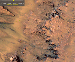
English: This series of images shows warm-season features that might be evidence of salty liquid water active on Mars today. Evidence for that possible interpretation is presented in a report by McEwen et al. in the Aug. 5, 2011, edition of Science.
These images come from observations of Newton crater, at 41.6 degrees south latitude, 202.3 degrees east longitude, by the High Resolution Imaging Science Experiment (HiRISE) camera on NASA's Mars Reconnaissance Orbiter. In time, the series spans from early spring of one Mars year to mid-summer of the following year. The images have been adjusted to correct those taken from oblique angles to show how the scene would look from directly overhead. The features that extend down the slope during warm seasons are called recurring slope lineae. They are narrow (one-half to five yards or meters wide), relatively dark markings on steep (25 to 40 degree) slopes at several southern hemisphere locations. Repeat imaging by HiRISE shows the features appear and incrementally grow during warm seasons and fade in cold seasons. They extend downslope from bedrock outcrops, often associated with small channels, and hundreds of them form in rare locations. They appear and lengthen in the southern spring and summer from 48 degrees to 32 degrees south latitudes favoring equator-facing slopes. These times and places have peak surface temperatures from about 10 degrees below zero Fahrenheit to 80 degree above zero Fahrenheit (about 250 to 300 Kelvin). Liquid brines near the surface might explain this activity, but the exact mechanism and source of the water are not understood. The series is timed to dwell two seconds on the first and last frames and one second on intermediate frames, though network or computer performance may cause this to vary. Other imagery related to these new findings from the Mars Reconnaissance Orbiter is at http://www.nasa.gov/mission_pages/MRO/multimedia/gallery/gallery-index.html The legend on each image gives the exact HiRISE observation number (e.g. ESP_011428_1380 for the first image) so that additional image products from the observation and information about the observation can be found on the HiRISE website (e.g., the first image of the series is from ESP_011428_1380, at http://hirise.lpl.arizona.edu/ESP_011428_1380). The legend also marks the Mars year and seasonal identifier (Ls) for each image. The Mars years begin with the first years of Mars exploration by robot spacecraft. This sequence includes images from Mars Year 29 and Mars Year 30. Ls stands for longitude of the sun, dividing the year into 360 degrees to mark the seasons. Ls = 180 is the beginning of southern spring, Ls = 270 is the beginning of southern summer, and Ls = 360 (or 0) is the beginning of southern autumn. HiRISE is operated by the University of Arizona, Tucson, and the instrument was built by Ball Aerospace & Technologies Corp., Boulder, Colo. NASA's Jet Propulsion Laboratory, a division of the California Institute of Technology in Pasadena, manages the Mars Reconnaissance Orbiter for NASA's Science Mission Directorate, Washington. Lockheed Martin Space Systems, Denver, built the spacecraft. |
|||||
| Data | prima del 6 agosto 2011 | |||||
| Fonte |
http://www.nasa.gov/mission_pages/MRO/multimedia/pia14472.html |
|||||
| Autore | NASA/JPL-Caltech/Univ. of Arizona | |||||
| Licenza (Riusare questo file) |
|

.gif?uselang=it)
.gif)
.gif&action=edit)
| Location on Mars | Posizione di questa e altre immagini su: Google Maps |
|---|
.gif¶ms=041.600000_N_-157.700000_E_globe:Mars__&language=it)
Questa immagine o filmato è stato catalogato dal Jet Propulsion Lab della National Aeronautics and Space Administration (NASA) degli Stati Uniti d'Americacon il Photo ID: PIA-14472.Questo tag non indica lo status del copyright dell'opera ad esso associato. È quindi richiesto un normale tag di copyright. Vedi Commons:Licenze per maggiori informazioni. Altre lingue:
|
Registro originale del caricamento
- 2011-08-05 12:08 Surajt88 1839×1518× (12278927 bytes) == Summary == {{Information |Description =This series of images shows warm-season features that might be evidence of salty liquid water active on Mars today. Evidence for that possible interpretation is presented in a report by McEwen et al. in the Aug
Cronologia del file
Fare clic su un gruppo data/ora per vedere il file come si presentava nel momento indicato.
| Data/Ora | Miniatura | Dimensioni | Utente | Commento | |
|---|---|---|---|---|---|
| attuale | 14:43, 5 ago 2011 | | 1 839 × 1 518 (11,71 MB) | Surajt88 | {{Information |Description={{en|This series of images shows warm-season features that might be evidence of salty liquid water active on Mars today. Evidence for that possible interpretation is presented in a report by McEwen et al. in the Aug. 5, 2011, ed |
Pagine che usano questo file
La seguente pagina usa questo file:
Utilizzo globale del file
Anche i seguenti wiki usano questo file:
- Usato nelle seguenti pagine di ar.wikipedia.org:
- Usato nelle seguenti pagine di ca.wikipedia.org:
- Usato nelle seguenti pagine di ca.wikinews.org:
- Usato nelle seguenti pagine di de.wikipedia.org:
- Usato nelle seguenti pagine di el.wikipedia.org:
- Usato nelle seguenti pagine di en.wikipedia.org:
- Usato nelle seguenti pagine di en.wikinews.org:
- Usato nelle seguenti pagine di es.wikipedia.org:
- Usato nelle seguenti pagine di fr.wikipedia.org:
- Usato nelle seguenti pagine di ja.wikipedia.org:
- Usato nelle seguenti pagine di pnb.wikipedia.org:
- Usato nelle seguenti pagine di ru.wikipedia.org:
- Usato nelle seguenti pagine di sr.wikipedia.org:
- Usato nelle seguenti pagine di th.wikipedia.org:
- Usato nelle seguenti pagine di uk.wikipedia.org:
- Usato nelle seguenti pagine di ur.wikipedia.org:
- Usato nelle seguenti pagine di zh.wikipedia.org:
.gif)