File:Sandy 2012-10-29 1815Z.jpg

File originale (11 202 × 18 000 pixel, dimensione del file: 67,73 MB, tipo MIME: image/jpeg)
| Questo file e la sua pagina di descrizione (discussione · modifica) si trovano su Wikimedia Commons (?) |
| Attenzione | Alcuni browser potrebbero avere dei problemi nel mostrare questa immagine a piena risoluzione: questa immagine è composta da un numero insolitamente alto di pixel e potrebbe non essere visualizzata correttamente o causare l'arresto del browser. |
|---|
Dettagli
| Descrizione |
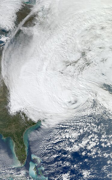
English: The Moderate Resolution Imaging Spectroradiometer (MODIS) on NASA’s Aqua satellite acquired this image of Hurricane Sandy at 2:20 p.m. Eastern Daylight Time (18:20 Universal Time) on October 29, 2012.
At 2:00 p.m. Eastern Daylight Time on October 29, the U.S. National Hurricane Center (NHC) reported that Hurricane Sandy was located about 110 miles (180 kilometers) southeast of Atlantic City, New Jersey, and about 175 miles (285 kilometers) south-southeast of New York City. The storm had maximum sustained winds of 90 miles (150 kilometers) per hour. The storm was moving toward the northwest at about 28 miles (44 kilometers) per hour. The NHC stated that Sandy could change into a wintertime low-pressure system later in the day, but cautioned that this would not weaken the storm prior to landfall. The NHC forecast that Hurricane Sandy would come ashore on the evening of October 29, along the coast of southern New Jersey or Delaware. The NHC warned of multiple hazards associated with the storm. Hurricane-force winds were predicted for the Mid-Atlantic States, including New York City, with tropical storm-force winds from Virginia to Canada. A storm surge, combined with astronomically high tides (at full Moon), promised to flood coastal areas with waters as much as 11 feet (3 meters) above normal. Sandy was forecast to drop as much as 8 inches (20 centimeters) of rain, and the mountains of Appalachia were expected to receive up to 3 feet (1 meter) of snow. The NHC urged potentially affected residents to consult their local National Weather Service forecast offices for more information. Government officials urged residents to heed evacuation warnings, and hundreds of thousands of people had fled their homes by October 29, CNN reported. More than 100,000 customers in seven states had already lost electrical power. In the days leading up to the storm, as residents stocked up on supplies and utility companies called in reinforcements from across the country, the U.S. Geological Survey deployed more than 150 storm-surge sensors along the Atlantic Coast to monitor Sandy’s effects in real time. |
| Data | |
| Fonte | http://lance-modis.eosdis.nasa.gov/cgi-bin/imagery/realtime.cgi?date=2012303 |
| Autore | NASA, MODIS/ LANCE, HDF File Data processed by Supportstorm, Caption by Michon Scott |
| Altre versioni |
.jpg) A cropped version is also available: File:Sandy Oct 29 2012 1815Z cropped.jpg A cropped version is also available: File:Sandy Oct 29 2012 1815Z cropped.jpg |
Licenza
| Questo file è nel pubblico dominio perché creato dalla NASA. La politica sul copyright della NASA afferma che «il materiale della NASA non è protetto da copyright a meno che non sia specificato altrimenti». (NASA copyright policy e JPL Image Use Policy). | ||
 |
Attenzione:
|
Cronologia del file
Fare clic su un gruppo data/ora per vedere il file come si presentava nel momento indicato.
| Data/Ora | Miniatura | Dimensioni | Utente | Commento | |
|---|---|---|---|---|---|
| attuale | 03:41, 30 ott 2012 | | 11 202 × 18 000 (67,73 MB) | Supportstorm | {{Information |Description ={{en|1=At 2:00 p.m. Eastern Daylight Time on October 29, the U.S. National Hurricane Center (NHC) reported that Hurricane Sandy was located about 110 miles (180 kilometers) southeast of Atlantic City, New Jersey, and abou... |
Pagine che usano questo file
Nessuna pagina utilizza questo file.
Utilizzo globale del file
Anche i seguenti wiki usano questo file:
- Usato nelle seguenti pagine di ar.wikipedia.org:
- Usato nelle seguenti pagine di az.wikipedia.org:
- Usato nelle seguenti pagine di ca.wikipedia.org:
- Usato nelle seguenti pagine di cy.wikipedia.org:
- Usato nelle seguenti pagine di de.wikipedia.org:
- Usato nelle seguenti pagine di en.wikipedia.org:
- Chris Christie
- Lorenzo Langford
- Bounty (1960 ship)
- Hurricane Sandy
- Effects of Hurricane Sandy in New Jersey
- Effects of Hurricane Sandy in New York
- Effects of Hurricane Sandy in the Greater Antilles
- Template:Hurricane Sandy series
- Effects of Hurricane Sandy in New England
- Meteorological history of Hurricane Sandy
- Effects of Hurricane Sandy in Canada
- Effects of Hurricane Sandy in Maryland and Washington, D.C.
- John B. Caddell
- Hurricane Sandy: Coming Together
- Political impact of Hurricane Sandy
- Occupy Sandy
- 12-12-12: The Concert for Sandy Relief
- 2012–13 North American winter
- 14th Street Tunnel shutdown
- Usato nelle seguenti pagine di gl.wikipedia.org:
- Usato nelle seguenti pagine di mr.wikipedia.org:
- Usato nelle seguenti pagine di no.wikipedia.org:
- Usato nelle seguenti pagine di pt.wikipedia.org:
- Usato nelle seguenti pagine di tr.wikipedia.org: