File:NASA RabaulVolcano PIA01767.jpg
Vai alla navigazione
Vai alla ricerca

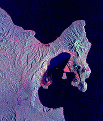
Dimensioni di questa anteprima: 515 × 600 pixel. Altre risoluzioni: 206 × 240 pixel | 412 × 480 pixel | 853 × 993 pixel.
File originale (853 × 993 pixel, dimensione del file: 855 KB, tipo MIME: image/jpeg)
| Questo file e la sua pagina di descrizione (discussione · modifica) si trovano su Wikimedia Commons (?) |
Dettagli
| Descrizione |
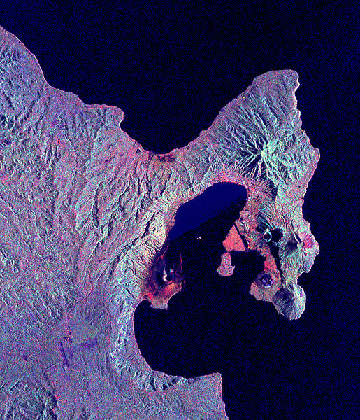
English: Space Radar Image of Rabaul Volcano, New Guinea
Credit NASA JPL http://visibleearth.nasa.gov/view_rec.php?id=434 This is a radar image of the Rabaul volcano on the island of New Britain, Papua New Guinea taken almost a month after its September 19, 1994, eruption that killed five people and covered the town of Rabaul and nearby villages with up to 75 centimeters (30 inches) of ash. More than 53,000 people have been displaced by the eruption. The image was acquired by the Spaceborne Imaging Radar-C/X-band Synthetic Aperture Radar (SIR-C/X-SAR) aboard the space shuttle Endeavour on its 173rd orbit on October 11, 1994. This image is centered at 4.2 degrees south latitude and 152.2 degrees east longitude in the southwest Pacific Ocean. The area shown is approximately 21 kilometers by 25 kilometers (13 miles by 15.5 miles). North is toward the upper right. The colors in this image were obtained using the following radar channels: red represents the L-band (horizontally transmitted and received); green represents the L-band (horizontally transmitted and vertically received); blue represents the C-band (horizontally transmitted and vertically received). |
|||||
| Fonte | http://visibleearth.nasa.gov/view_rec.php?id=434 | |||||
| Autore | NASA/JPL | |||||
| Licenza (Riusare questo file) |
|

Questa immagine o filmato è stato catalogato dal Jet Propulsion Lab della National Aeronautics and Space Administration (NASA) degli Stati Uniti d'Americacon il Photo ID: PIA01767.Questo tag non indica lo status del copyright dell'opera ad esso associato. È quindi richiesto un normale tag di copyright. Vedi Commons:Licenze per maggiori informazioni. Altre lingue:
|
Registro originale del caricamento
La pagina di descrizione originale era qui. Tutti i nomi utente che seguono sono riferiti a en.wikipedia.
- 2005-05-17 12:15 SeanMack 853×993× (875239 bytes) {{PD-USGov-NASA}} Space Radar Image of Rabaul Volcano, New Guinea Credit NASA JPL http://visibleearth.nasa.gov/view_rec.php?id=434 This is a radar image of the Rabaul volcano on the island of New Britain, Papua New Guinea taken almost a month after
Cronologia del file
Fare clic su un gruppo data/ora per vedere il file come si presentava nel momento indicato.
| Data/Ora | Miniatura | Dimensioni | Utente | Commento | |
|---|---|---|---|---|---|
| attuale | 15:17, 1 mag 2009 | | 853 × 993 (855 KB) | File Upload Bot (Magnus Manske) | {{BotMoveToCommons|en.wikipedia|year={{subst:CURRENTYEAR}}|month={{subst:CURRENTMONTHNAME}}|day={{subst:CURRENTDAY}}}} {{Information |Description={{en|Space Radar Image of Rabaul Volcano, New Guinea Credit NASA JPL http://visibleearth.nasa.gov/view_re |
Pagine che usano questo file
La seguente pagina usa questo file:
Utilizzo globale del file
Anche i seguenti wiki usano questo file:
- Usato nelle seguenti pagine di br.wikipedia.org:
- Usato nelle seguenti pagine di en.wikipedia.org:
- Usato nelle seguenti pagine di fa.wikipedia.org:
- Usato nelle seguenti pagine di fr.wikipedia.org:
- Usato nelle seguenti pagine di hu.wikipedia.org:
- Usato nelle seguenti pagine di id.wikipedia.org:
- Usato nelle seguenti pagine di ja.wikipedia.org:
- Usato nelle seguenti pagine di ko.wikipedia.org:
- Usato nelle seguenti pagine di nl.wikipedia.org:
- Usato nelle seguenti pagine di ru.wikipedia.org:
- Usato nelle seguenti pagine di uk.wikipedia.org:
- Usato nelle seguenti pagine di zh.wikipedia.org: