File:Louisiade archipelago.jpg
Vai alla navigazione
Vai alla ricerca

Dimensioni di questa anteprima: 800 × 600 pixel. Altre risoluzioni: 320 × 240 pixel | 640 × 480 pixel | 1 024 × 768 pixel | 1 280 × 960 pixel | 2 000 × 1 500 pixel.
File originale (2 000 × 1 500 pixel, dimensione del file: 449 KB, tipo MIME: image/jpeg)
| Questo file e la sua pagina di descrizione (discussione · modifica) si trovano su Wikimedia Commons (?) |
Dettagli
| Descrizione |
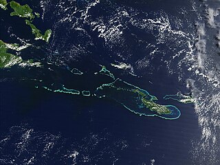
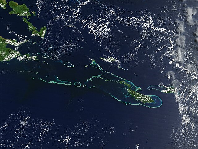
English: Off the southeast tip of Papua New Guinea lies a string of small volcanic islands and coral reefs collectively called the Louisiade Archipelago. This true-color MODIS image from September 11, 2002, is centered on the island chain, with Papua New Guinea at the left edge. Moving westward from eastern end of the chain are the islands of Rossel and Tagula. (Misima Island, which harbors the largest village in the region, is obscured by a patch of clouds northeast of image center.) To the north of the chain lies the Solomon Sea, and to the south is the Coral Sea. Most of the undisturbed land is covered by tropical rainforest, and despite their small size, the islands harbor a number of plant and animal species found nowhere else. |
| Data | 7 maggio 2005 (data di caricamento originaria) |
| Fonte | Transferred from en.wikipedia |
| Autore | NASA |
Licenza
| Questo file è nel pubblico dominio perché creato dalla NASA. La politica sul copyright della NASA afferma che «il materiale della NASA non è protetto da copyright a meno che non sia specificato altrimenti». (NASA copyright policy e JPL Image Use Policy). | ||
 |
Attenzione:
|
Registro originale del caricamento
All following user names refer to en.wikipedia.
- 2005-05-07 02:55 PDH 2000×1500× (459961 bytes) Off the southeast tip of Papua New Guinea lies a string of small volcanic islands and coral reefs collectively called the Louisiade Archipelago. This true-color MODIS image from September 11, 2002, is centered on the island chain, with Papua New Guinea at
Cronologia del file
Fare clic su un gruppo data/ora per vedere il file come si presentava nel momento indicato.
| Data/Ora | Miniatura | Dimensioni | Utente | Commento | |
|---|---|---|---|---|---|
| attuale | 10:55, 18 ott 2009 | | 2 000 × 1 500 (449 KB) | Urdangaray | {{Information |Description={{en|Off the southeast tip of Papua New Guinea lies a string of small volcanic islands and coral reefs collectively called the Louisiade Archipelago. This true-color MODIS image from September 11, 2002, is centered on the island |
Pagine che usano questo file
Le seguenti 2 pagine usano questo file:
Utilizzo globale del file
Anche i seguenti wiki usano questo file:
- Usato nelle seguenti pagine di als.wikipedia.org:
- Usato nelle seguenti pagine di ast.wikipedia.org:
- Usato nelle seguenti pagine di br.wikipedia.org:
- Usato nelle seguenti pagine di ca.wikipedia.org:
- Usato nelle seguenti pagine di ceb.wikipedia.org:
- Usato nelle seguenti pagine di de.wikipedia.org:
- Usato nelle seguenti pagine di en.wikipedia.org:
- Usato nelle seguenti pagine di en.wikivoyage.org:
- Usato nelle seguenti pagine di eo.wikipedia.org:
- Usato nelle seguenti pagine di es.wikipedia.org:
- Usato nelle seguenti pagine di eu.wikipedia.org:
- Usato nelle seguenti pagine di he.wikivoyage.org:
- Usato nelle seguenti pagine di hy.wikipedia.org:
- Usato nelle seguenti pagine di it.wikivoyage.org:
- Usato nelle seguenti pagine di ka.wikipedia.org:
- Usato nelle seguenti pagine di la.wikipedia.org:
- Usato nelle seguenti pagine di or.wikipedia.org:
- Usato nelle seguenti pagine di pl.wikipedia.org:
- Usato nelle seguenti pagine di vi.wikipedia.org:
- Usato nelle seguenti pagine di www.wikidata.org: