File:A Nearly Ice-Free Northwest Passage vir 2016222 lrg.jpg

File originale (6 136 × 4 272 pixel, dimensione del file: 4,09 MB, tipo MIME: image/jpeg)
| Questo file e la sua pagina di descrizione (discussione · modifica) si trovano su Wikimedia Commons (?) |
Dettagli
| Descrizione |
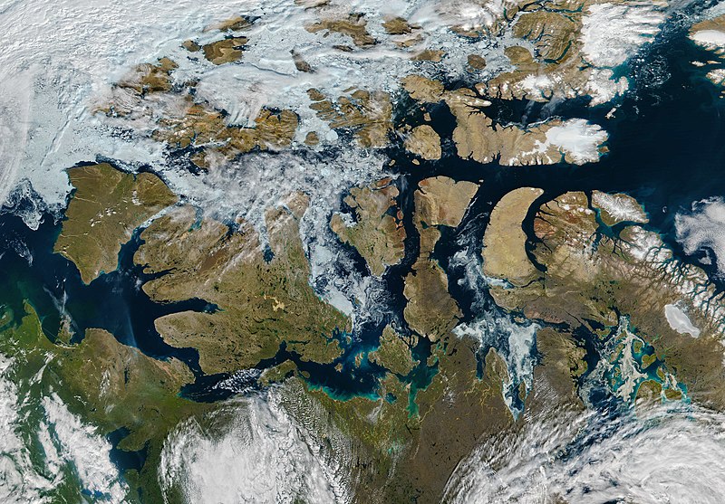
English: The Northwest Passage is a famed high-latitude sea route in the Arctic. The route meanders through the Canadian Arctic Archipelago, connecting the North Atlantic and Pacific Oceans. For most of the year, its waters are choked with sea ice. But by mid-August 2016, the passage was nearly ice-free.
The Visible Infrared Imaging Radiometer Suite (VIIRS) on the Suomi NPP satellite captured this image of the Northwest Passage on August 9, 2016. A path of open water can be traced almost the entire distance from the Amundsen Gulf to Baffin Bay, encountering a scattering of broken ice just east of Victoria Island. This is not the first Arctic summer with so much open water. According to NOAA, the more frequent opening of the Northwest Passage means that it is becoming an increasingly viable route for shipping.Deutsch: Die Nordwestpassage ist eine berühmte Schifffahrtsroute in den hohen Breiten der Arktis; sie schlängelt sich durch den Kanadisch-arktischen Archipel und verbindet den Nordatlantik mit dem Pazifischen Ozean. Den größten Teil des Jahres sind diese Gewässer eisbedeckt, doch Mitte August 2016 war die Passage fast durchgehend eisfrei.
Die Visible Infrared Imaging Radiometer Suite (VIIRS) auf dem Suomi NPP Satellite zeichnete am 9. August 2016 dieses Bid auf. Ein Pfad mit offenem Fahrwasser reichte dabei fast die gesamte Strecke vom Amundsengolf bis zur Baffininsel, nur direkt östlich von Victoria Island sind Eisreste vorhanden. 2016 ist nicht der erste arktische Sommer mit derart ausgedehnten offenen Wasserflächen. Nach Ansicht der NOAA bedeutet die häufigere Öffnung des Wasserweges, dass die Nordwestpassage zunehmend zu einer verlässlichen Schifffahrtsverbindung wird. |
| Data | |
| Fonte | http://earthobservatory.nasa.gov/NaturalHazards/view.php?id=88597 |
| Autore | NASA image by Jeff Schmaltz, LANCE/EOSDIS Rapid Response, using VIIRS data from the Suomi National Polar-orbiting Partnership satellite. Suomi NPP is the result of a partnership between NASA, the National Oceanic and Atmospheric Administration, and the Department of Defense. Caption by Kathryn Hansen. |
| Altre versioni | File:A Nearly Ice-Free Northwest Passage vir 2016222 (annotated).jpg |
.jpg)
References and Related Reading
- NASA Earth Observatory (2015, September 13) Partial Opening of the Northwest Passage.
- National Snow & Ice Data Center (2016, August 16) Late summer in the Arctic, sea ice melt continues. Accessed August 18, 2016.
- NOAA Environmental Visualization Laboratory (2016, August 11) Suomi NPP sees the Northwest Passage. Accessed August 18, 2016.
Licenza
| Questo file è nel pubblico dominio perché creato dalla NASA. La politica sul copyright della NASA afferma che «il materiale della NASA non è protetto da copyright a meno che non sia specificato altrimenti». (NASA copyright policy e JPL Image Use Policy). | ||
 |
Attenzione:
|
Cronologia del file
Fare clic su un gruppo data/ora per vedere il file come si presentava nel momento indicato.
| Data/Ora | Miniatura | Dimensioni | Utente | Commento | |
|---|---|---|---|---|---|
| attuale | 00:57, 20 ago 2016 | | 6 136 × 4 272 (4,09 MB) | Matthiasb | {{Information |Description ={{en|1=The Northwest Passage is a famed high-latitude sea route in the Arctic. The route meanders through the Canadian Arctic Archipelago, connecting the North Atlantic and Pacific Oceans. For most of the year, its waters... |
Pagine che usano questo file
Nessuna pagina utilizza questo file.
Utilizzo globale del file
Anche i seguenti wiki usano questo file:
- Usato nelle seguenti pagine di en.wikipedia.org:
- Usato nelle seguenti pagine di fi.wikipedia.org:
- Usato nelle seguenti pagine di he.wikipedia.org:
- Usato nelle seguenti pagine di id.wikipedia.org:
- Usato nelle seguenti pagine di ky.wikipedia.org: