File:US-Population-Center-Illinois-and-Missouri.png
Vai alla navigazione
Vai alla ricerca

Dimensioni di questa anteprima: 573 × 600 pixel. Altre risoluzioni: 229 × 240 pixel | 639 × 669 pixel.
File originale (639 × 669 pixel, dimensione del file: 160 KB, tipo MIME: image/png)
| Questo file e la sua pagina di descrizione (discussione · modifica) si trovano su Wikimedia Commons (?) |
Dettagli
| Descrizione |
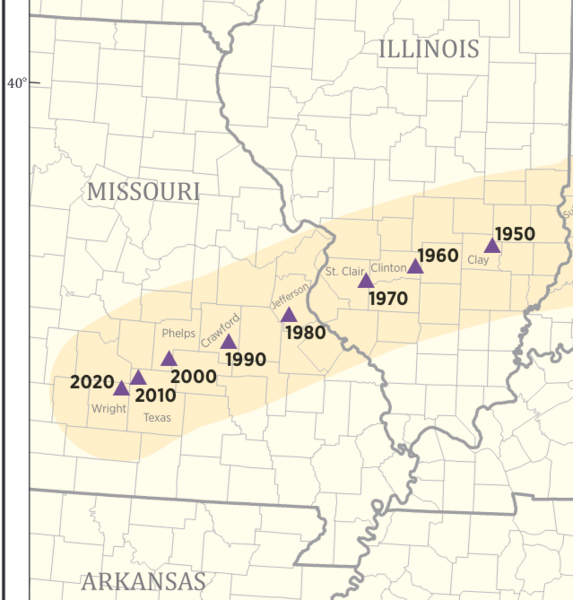
English: The mean center of the United States population from 1950 to 2020, as published by the U.S. Census bureau. In 1950 through 1970, the center was in the state of Illinois, but since 1980, the center has been in the state of Missouri. Published at: https://www.census.gov/library/visualizations/2020/geo/center-of-population-1790-2020.html |
| Data | |
| Fonte | https://www2.census.gov/geo/maps/DC2020/PopCenter/CenterPop_Mean_1790-2020.pdf |
| Autore | Published by the U.S. Census bureau |
Licenza
This image or file is a work of a United States Census Bureau employee, taken or made as part of that person's official duties. As a work of the U.S. federal government, the image is in the public domain.
|
 |
Cronologia del file
Fare clic su un gruppo data/ora per vedere il file come si presentava nel momento indicato.
| Data/Ora | Miniatura | Dimensioni | Utente | Commento | |
|---|---|---|---|---|---|
| attuale | 12:35, 23 nov 2021 | | 639 × 669 (160 KB) | RobLa | Uploaded a work by Published by the U.S. Census bureau from https://www2.census.gov/geo/maps/DC2020/PopCenter/CenterPop_Mean_1790-2020.pdf with UploadWizard |
Pagine che usano questo file
La seguente pagina usa questo file:
Utilizzo globale del file
Anche i seguenti wiki usano questo file:
- Usato nelle seguenti pagine di en.wikipedia.org:
- Usato nelle seguenti pagine di ro.wikipedia.org: