File:Trails of Tears en.png
Vai alla navigazione
Vai alla ricerca

Dimensioni di questa anteprima: 785 × 600 pixel. Altre risoluzioni: 314 × 240 pixel | 628 × 480 pixel | 1 005 × 768 pixel | 1 280 × 978 pixel | 2 025 × 1 547 pixel.
File originale (2 025 × 1 547 pixel, dimensione del file: 3,04 MB, tipo MIME: image/png)
| Questo file e la sua pagina di descrizione (discussione · modifica) si trovano su Wikimedia Commons (?) |
Dettagli
| Descrizione |
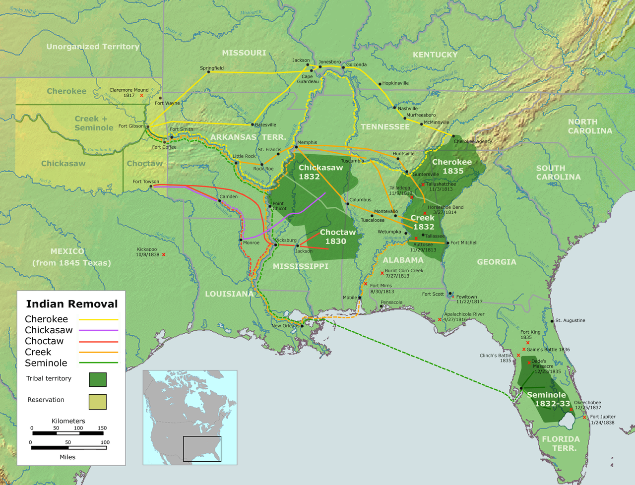
English: Map of the route of the Trails of Tears — depicting the route taken to relocate Native Americans from the Southeastern United States between 1836 and 1839.
|
||||
| Data | |||||
| Fonte |
Opera propria usando::
|
||||
| Autore | User:Nikater | ||||
| Licenza (Riusare questo file) |
|
||||
| Altre versioni |
|

Cronologia del file
Fare clic su un gruppo data/ora per vedere il file come si presentava nel momento indicato.
| Data/Ora | Miniatura | Dimensioni | Utente | Commento | |
|---|---|---|---|---|---|
| attuale | 20:37, 4 set 2007 | | 2 025 × 1 547 (3,04 MB) | Nikater | {{Information |Description=Trails of Tears (English version) |Source=Own work by Nikater, submitted to the public domain. Background map courtesy of Demis, www.demis.nl and Wilcomb E. Washburn (Hrsg.) ''Handbook of North American Indians.'' Vol. 4: Histor |
| 09:55, 4 set 2007 |  | 2 025 × 1 547 (3,04 MB) | Nikater | {{Information |Description=Trails of Tears (English version) |Source=Own work by Nikater, submitted to the public domain. Background map courtesy of Demis, www.demis.nl and Wilcomb E. Washburn (Hrsg.) ''Handbook of North American Indians.'' Vol. 4: Histor |
Pagine che usano questo file
Le seguenti 4 pagine usano questo file:
Utilizzo globale del file
Anche i seguenti wiki usano questo file:
- Usato nelle seguenti pagine di af.wikipedia.org:
- Usato nelle seguenti pagine di am.wikipedia.org:
- Usato nelle seguenti pagine di ar.wikipedia.org:
- Usato nelle seguenti pagine di bcl.wikiquote.org:
- Usato nelle seguenti pagine di be.wikipedia.org:
- Usato nelle seguenti pagine di bg.wikipedia.org:
- Usato nelle seguenti pagine di bn.wikipedia.org:
- Usato nelle seguenti pagine di ca.wikipedia.org:
- Destí Manifest
- Neteja ètnica
- Andrew Jackson
- James Monroe
- Guerres índies
- Deportació dels indis dels Estats Units
- Camí de les Llàgrimes
- Territori Indi
- Tractat de Dancing Rabbit Creek
- Camí de les Llàgrimes choctaw
- Plantilla:Deportació ameríndia
- Tractat de Payne's Landing
- Indian Removal Act
- Tractat de Doak's Stand
- Tractat de Hopewell
- Tractat de Prairie du Chien
- Usuari:Carmallola/Neteja ètnica
- Usato nelle seguenti pagine di cs.wikipedia.org:
- Usato nelle seguenti pagine di de.wikipedia.org:
- Usato nelle seguenti pagine di en.wikipedia.org:
- Indian removal
- Winfield Scott
- History of the United States
- Trail of Tears
- Five Civilized Tribes
- History of the Southern United States
- Portal:Oklahoma
- History of Oklahoma
- History of Arkansas
- Presidency of Andrew Jackson
- User talk:Kevin1776/Archive 3
- Aboriginal title in the United States
- Cherokee Nation (1794–1907)
- User:Boompole/sandbox
- Oklahoma Organic Act
- User:Joelton Ivson/Gather lists/24319 – Indígenas América do Norte
- User:Squeakinglemur/sandbox
Visualizza l'utilizzo globale di questo file.