File:Tannenberg3008.jpg
Vai alla navigazione
Vai alla ricerca
Dimensioni di questa anteprima: 775 × 600 pixel. Altre risoluzioni: 310 × 240 pixel | 620 × 480 pixel | 993 × 768 pixel | 1 242 × 961 pixel.
File originale (1 242 × 961 pixel, dimensione del file: 207 KB, tipo MIME: image/jpeg)
| Questo file e la sua pagina di descrizione (discussione · modifica) si trovano su Wikimedia Commons (?) |

|
File:East Prussian Campaign (27—30 Aug 1914) - ru.svg è una versione vettoriale di questo file. Dovrebbe essere usata quella versione al posto di questo file JPG, quando sia migliore.
File:Tannenberg3008.jpg → File:East Prussian Campaign (27—30 Aug 1914) - ru.svg
Per maggiori informazioni, vedi Help:SVG. |
_-_ru.svg) |
| Descrizione |
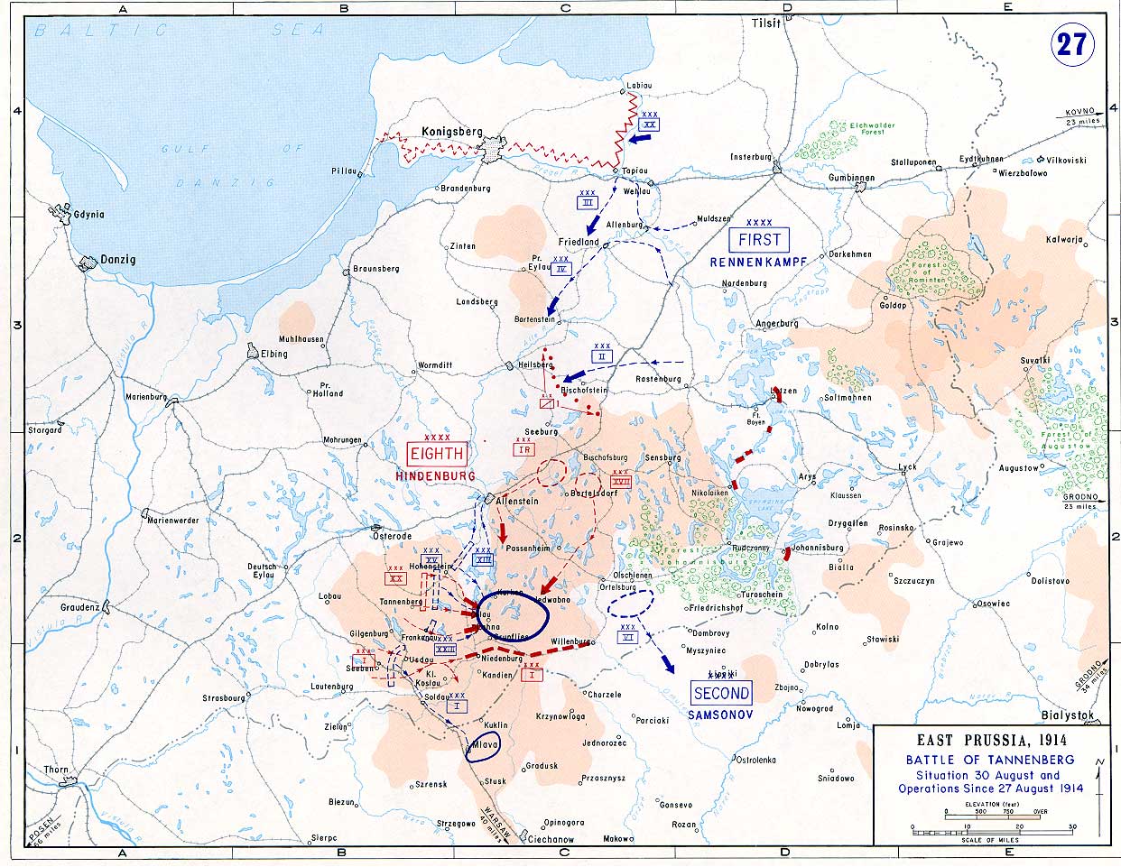
English: Battle of Tannenberg (1914) in its last phase |
| Fonte |
Taken from the campaign series, made public by the US-Army under dean.usma.edu
|
| Autore | US-Army under www.dean.usma.edu |
| Licenza (Riusare questo file) |
The picture is public domain. |
Questo file multimediale è stato realizzato da un soldato o da un dipendente dell'Esercito degli Stati Uniti durante il suo servizio. Essendo un'opera del governo federale statunitense, il file è nel pubblico dominio.
|
 |
Cronologia del file
Fare clic su un gruppo data/ora per vedere il file come si presentava nel momento indicato.
| Data/Ora | Miniatura | Dimensioni | Utente | Commento | |
|---|---|---|---|---|---|
| attuale | 16:29, 22 set 2005 | | 1 242 × 961 (207 KB) | Nasiruddin | Taken from the campaign series, made public by the US-Army under www.dean.usma.edu The öpicture is public domain. It shows the battle of Tannenberg in its last phase {{PD-USGov-Military-Army}} Category:World War I maps |
Pagine che usano questo file
La seguente pagina usa questo file:
Utilizzo globale del file
Anche i seguenti wiki usano questo file:
- Usato nelle seguenti pagine di be-tarask.wikipedia.org:
- Usato nelle seguenti pagine di be.wikipedia.org:
- Usato nelle seguenti pagine di ca.wikipedia.org:
- Usato nelle seguenti pagine di cs.wikipedia.org:
- Usato nelle seguenti pagine di da.wikipedia.org:
- Usato nelle seguenti pagine di de.wikipedia.org:
- Usato nelle seguenti pagine di el.wikipedia.org:
- Usato nelle seguenti pagine di en.wikipedia.org:
- Usato nelle seguenti pagine di et.wikipedia.org:
- Usato nelle seguenti pagine di fi.wikipedia.org:
- Usato nelle seguenti pagine di fr.wikipedia.org:
- Usato nelle seguenti pagine di he.wikipedia.org:
- Usato nelle seguenti pagine di hr.wikipedia.org:
- Usato nelle seguenti pagine di ja.wikipedia.org:
- Usato nelle seguenti pagine di ko.wikipedia.org:
- Usato nelle seguenti pagine di lv.wikipedia.org:
- Usato nelle seguenti pagine di nl.wikipedia.org:
- Usato nelle seguenti pagine di no.wikipedia.org:
- Usato nelle seguenti pagine di pl.wikipedia.org:
- Usato nelle seguenti pagine di sv.wikipedia.org:
- Usato nelle seguenti pagine di uk.wikipedia.org:
- Usato nelle seguenti pagine di vi.wikipedia.org:
- Usato nelle seguenti pagine di zh.wikipedia.org: