File:Sanson Amerique Septentrionale 1650 UTA.jpg

File originale (3 836 × 2 688 pixel, dimensione del file: 1,89 MB, tipo MIME: image/jpeg)
| Questo file e la sua pagina di descrizione (discussione · modifica) si trovano su Wikimedia Commons (?) |
Dettagli
| Titolo |
Français : Amerique Septentrionale |
||||||||||||||||||||||||||
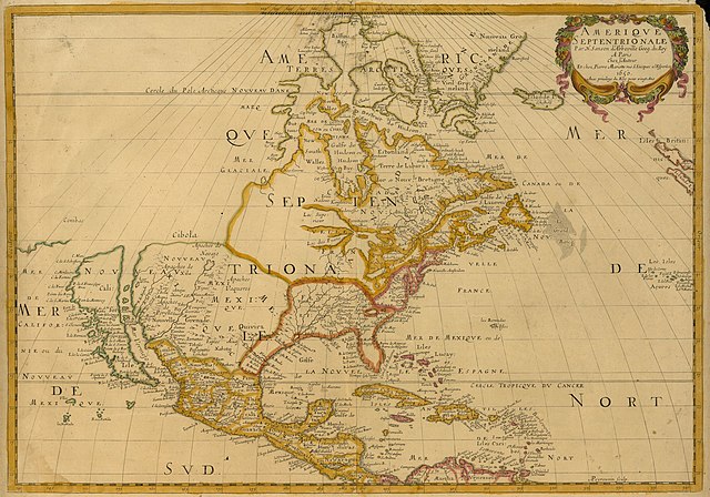
| Descrizione |
English: Sanson's landmark 1650 map of North America includes interesting details relating to chartered company operations in the northern and eastern part of the continent as well as the Caribbean. Employing a sinusoidal projection, its construction demonstrates considerable scientific acumen. Much of the Great Lakes system now appears, with Lakes Superior and Ontario named for the first time. Sanson's sources must have included the annual reports of the Jesuits which included eyewitness accounts of their missionary activities and explorations in association with the chartered fur companies. These augmented the earlier explorations of Champlain. There is also "Mon Royal", or Montreal, laid out as a trading site by Champlain in 1611. "N[ouvelle]. Anglet[erre]" refers to New England, while "Nouvelle Amsterdam" and "Nouvelle Hollandia" on the east coast allude to activities there of the New Netherland Company (beginning in 1614) and the Dutch WIC (beginning in 1625). There is even "N[ouvelle]. Suede" relating to the new settlements in the Delaware Valley of the New Sweden Company chartered by the Swedish government in 1638. |
||||||||||||||||||||||||||
| Data | o 1651 | ||||||||||||||||||||||||||
| Fonte | UTA Libraries Cartographic Connections: mappa / testo | ||||||||||||||||||||||||||
| Creatore |
|
||||||||||||||||||||||||||
| Attribuzione |
English: UTA Libraries Special Collections |
||||||||||||||||||||||||||
| Geotemporal data | |||||||||||||||||||||||||||
| Map location | America del Nord | ||||||||||||||||||||||||||
| Georeferencing | If inappropriate please set warp_status = skip to hide. | ||||||||||||||||||||||||||
| Luogo di pubblicazione | Parigi | ||||||||||||||||||||||||||
| Archival data | |||||||||||||||||||||||||||
| Collezione |
|
||||||||||||||||||||||||||
| Dimensioni | altezza: 38 cm; larghezza: 54 cm | ||||||||||||||||||||||||||
| Tecnica/materiale | incisione colorata | ||||||||||||||||||||||||||
| artwork-references |
Burden The Mapping of North America I, nº294 , pp. 375−377 Schwartz and Ralph Ehrenberg The Mapping of America, 5, nº61 , pp. 111−112 Hayes Historical Atlas of Canada, 1, p. 60 Martin e Martin Maps of Texas and the Southwest, 1, pp. 82−83 |
||||||||||||||||||||||||||

Licenza

|
This file was provided to Wikimedia Commons by the University of Texas at Arlington Libraries as part of a cooperation project. The University of Texas at Arlington Libraries is part of the University of Texas at Arlington, a public research university located in Arlington, Texas.
|
|
L'autore è deceduto nel 1667, quindi quest'opera è nel pubblico dominio anche in tutti i Paesi e nelle aree in cui la durata del copyright è la vita dell'autore più 100 anni o meno. Quest'opera è nel pubblico dominio negli Stati Uniti in quanto pubblicata (o registrata all'U.S. Copyright Office) prima del 1º gennaio 1929. | |
| Questo file è stato identificato come libero da restrizioni conosciute riguardanti le leggi sul copyright, compresi tutti i diritti connessi e vicini. | |
Cronologia del file
Fare clic su un gruppo data/ora per vedere il file come si presentava nel momento indicato.
| Data/Ora | Miniatura | Dimensioni | Utente | Commento | |
|---|---|---|---|---|---|
| attuale | 17:27, 8 feb 2022 | | 3 836 × 2 688 (1,89 MB) | Michael Barera | == {{int:filedesc}} == {{Map |title = {{la|'''''Amerique Septentrionale'''''}} |description = {{en|Sanson's landmark 1650 map of North America includes interesting details relating to chartered company operations in the northern and eastern part of the continent as well as the Caribbean. Employing a sinusoidal projection, its construction demonstrates considerable scientific acumen. Much of the Great Lakes system now appears, with Lakes Superior and Ontario named for the f... |
Pagine che usano questo file
Le seguenti 2 pagine usano questo file:
Utilizzo globale del file
Anche i seguenti wiki usano questo file:
- Usato nelle seguenti pagine di de.wikipedia.org:
- Usato nelle seguenti pagine di en.wikipedia.org:
- Usato nelle seguenti pagine di es.wikipedia.org:
- Usato nelle seguenti pagine di fa.wikipedia.org:
- Usato nelle seguenti pagine di ja.wikipedia.org:
- Usato nelle seguenti pagine di ko.wikipedia.org:
- Usato nelle seguenti pagine di pt.wikipedia.org:
- Usato nelle seguenti pagine di ru.wikipedia.org: