File:Lexington Concord Siege of Boston crop.jpg
File originale (2 861 × 2 188 pixel, dimensione del file: 1,89 MB, tipo MIME: image/jpeg)
| Questo file e la sua pagina di descrizione (discussione · modifica) si trovano su Wikimedia Commons (?) |
Dettagli
| Descrizione |
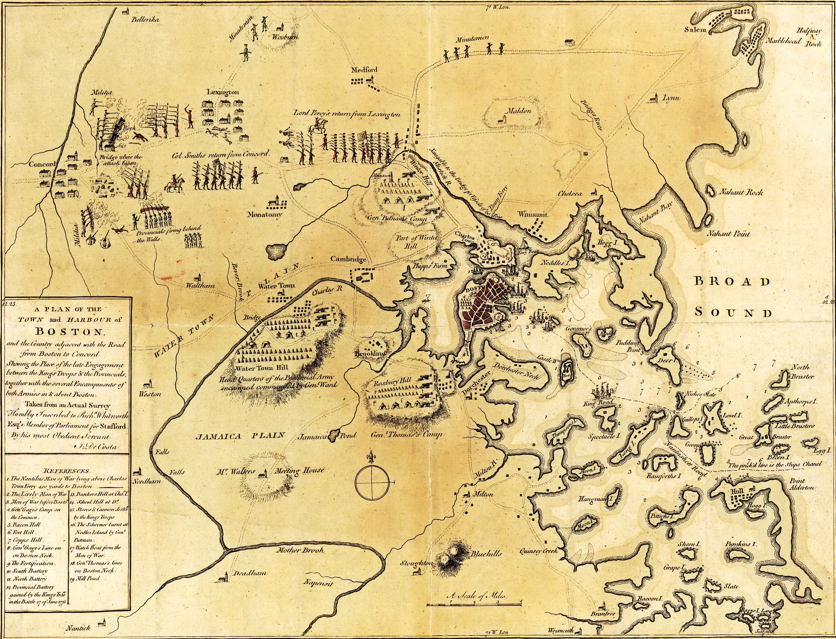
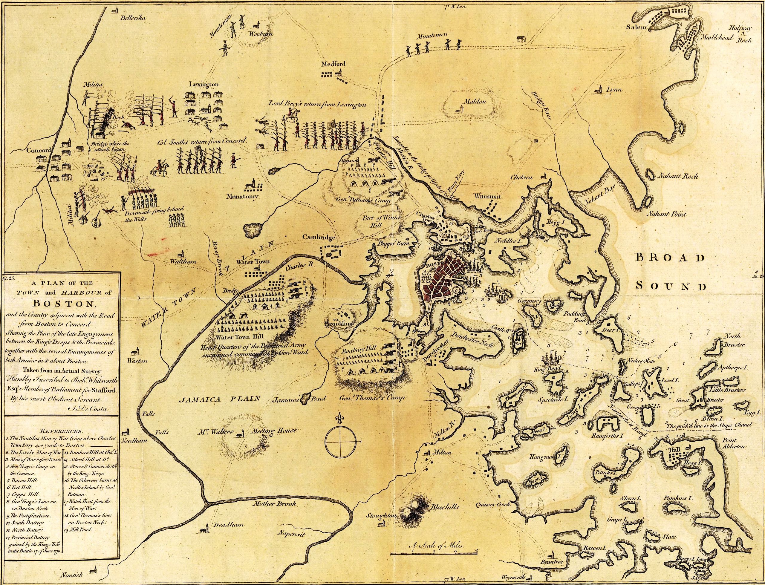
English: A mostly accurate hand-colored map depicting the 1775 Battles of Lexington and Concord and the Siege of Boston |
| Data | |
| Fonte |
From the Library of Congress American Memory. |
| Autore | J. DeCosta |
| Altre versioni |
 |
Large text box
TOWN and HARBOUR of
Boston.
and the Country adjacent with the Road
from Boston to Concord
Shewing the Place of the late Engagement
between the King's Troops & the Provincials,
together with the several Encampments of
both Armies in & about Boston.
Taken from an Actual Survey
Humbly Inscribed to Rich d. Whitworth
Esqr. Member of Parliament for Stafford
Legend
References.
- The Nautilus Man of War lying above Charles
- Town Ferry 400 yards to Boston
- The Lively Man of War
- Men of War before Boston.
- Gen l. Gage's Camp on
- the Common.
- Bacon Hill [i.e. Beacon Hill]
- Fort Hill.
- Copps Hill.
- Gen l. Gage's Line on
- on Boston Neck.
- The Fortification.
- South Battery
- North Battery
- Provincial Battery
- gained by the King's Troo ps
- in the Battle 17 of June 1775
- Bunkers Hill at Cha s. T.
- School Hill at D o.
- Stores & Cannon destro d
- by the King's Troops
- The Schooner burnt at
- Nodles Island by Gen l.
- Putman
- Watch Boat from the Men of War.
- Gen l. Thomas's lines
- on Boston Neck
- Mill Pond
Text along the bottom
- London Publish'd as the Act directs July 29th. 1775 by J. De Costa Red Croſs Street Southwark.

|
Questa map è disponibile presso la Geografia e Mappa Divisione (Geography & Map Division) della Biblioteca del Congresso sotto l'ID digitale g3764b.ar090000.
Questo tag non indica lo status del copyright dell'opera ad esso associato. È quindi richiesto un normale tag di copyright. Vedi Commons:Licenze per maggiori informazioni.
|
|
Quest'opera è nel pubblico dominio anche in tutti i Paesi e nelle aree in cui la durata del copyright è la vita dell'autore più 100 anni o meno. | |
| Questo file è stato identificato come libero da restrizioni conosciute riguardanti le leggi sul copyright, compresi tutti i diritti connessi e vicini. | |
Cronologia del file
Fare clic su un gruppo data/ora per vedere il file come si presentava nel momento indicato.
| Data/Ora | Miniatura | Dimensioni | Utente | Commento | |
|---|---|---|---|---|---|
| attuale | 05:00, 4 lug 2014 | | 2 861 × 2 188 (1,89 MB) | Beyond My Ken | == {{int:filedesc}} == {{Information |author=J. DeCosta |date=1775-07-29 |description={{en|A mostly accurate hand-colored map depicting the 1775 Battles of Lexington and Concord and the [[w:Siege of Boston|Siege o... |
Pagine che usano questo file
La seguente pagina usa questo file:
Utilizzo globale del file
Anche i seguenti wiki usano questo file:
- Usato nelle seguenti pagine di azb.wikipedia.org:
- Usato nelle seguenti pagine di cs.wikipedia.org:
- Usato nelle seguenti pagine di en.wikipedia.org:
- Usato nelle seguenti pagine di ru.wikipedia.org: