Paludi di Lubiana

La palude di Lubiana (in sloveno Ljubljansko barje) è situata a sud della capitale Lubiana, hanno una dimensione di 163km2 e coprono lo 0,8% della superficie dello stato sloveno. Risiedono nei comuni di Lubiana, Borovnica, Log-Dragomer, Škofljica e Nauporto [1].
Biodiversity
The Ljubljana Marshes is a place of great biodiversity. Since 2008, the major part of the Ljubljana Marshes, covering an area of 135 km² (52 mi²), has been protected as a landscape park. The most preserved parts had been already before protected as nature reserves and as natural monuments.[2]
History
Template:Multiple image The Ljubljana Marsh was inhabited in prehistoric times, when it was a shallow lake. Prehistoric pile dwellings and the oldest wooden wheel in the world[3] are among the most notable archeological findings from the marshland. Since 2011, the area of pile dwellings near Ig has been protected as a UNESCO World Heritage Site.[4]
The first road through the marsh, connecting Ljubljana to Studenec (now Ig), was begun in 1825 and completed in 1827. The work was carried out under Mayor Johann Nepomuk Hradeczky (1775–1846) and the provincial governor, Baron Joseph Camillo von Schmidburg (1779–1846). Emperor Francis I of Austria and Empress Caroline Augusta of Bavaria inspected the road in 1830, and a monument was erected to the achievement in 1833.[5]
The marshland includes a number of hamlets that belong to the city of Ljubljana: Ilovica, Volar, Pri Strahu, Pri Maranzu, Kožuh, and Havptmance (from north to south). Ilovica was settled relatively late, starting in 1838, and had only six farms by 1860. Volar lies between the Iščica and Ljubljanica rivers and was settled after 1830, when it was also officially designated Karolinska zemlja (Template:Lang-de), literally 'Caroline's land', in honor of Caroline Augusta of Bavaria. Kožuh lies further south, and Havptmance east of Kožuh. Havptmance was already mentioned as a place in the 18th century and was settled in the 1870s, when peat extraction was a major economic activity. The name Havptmance probably refers to the fact that the provincial governor (Template:Lang-de) had his hunting grounds in the area.[6]
-
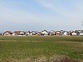 Kožuh
Kožuh -
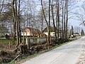 Havptmance


Recreational and tourist site

The Ljubljana Marshes is very popular among balloonists.
- Accident
On 23 August 2012, a pilot without a valid pilot certificate caused the 2012 balloon crash which occurred on the Ljubljana Marshes, with several people dead and a number of passengers severely burned and injured. New, stricter protocol for pilots was introduced by the authorities to make balloon trips safe.[7]
- ^ Home
- ^ Ljubljansko barje je območje Natura 2000
- ^ Najstarejše kolo z osjo na svetu - 5150 let
- ^ Prehistoric Pile dwellings around the Alps - UNESCO World Heritage Centre
- ^ Inscription on roadside monument in Ilovica.
- ^ Savnik, Roman, ed. 1971. Krajevni leksikon Slovenije, vol. 2. Ljubljana: Državna založba Slovenije, p. 317.
- ^ Množična nesreča zaradi strmoglavljenja balona (23.8.2012), su sos112.si, Administration for Civil Protection and Disaster Relief of the Republic of Slovenia.