File:VaFrontier2.jpg
Vai alla navigazione
Vai alla ricerca
Non sono disponibili versioni a risoluzione più elevata.
VaFrontier2.jpg (479 × 217 pixel, dimensione del file: 27 KB, tipo MIME: image/jpeg)
| Questo file e la sua pagina di descrizione (discussione · modifica) si trovano su Wikimedia Commons (?) |
Dettagli
| Descrizione |
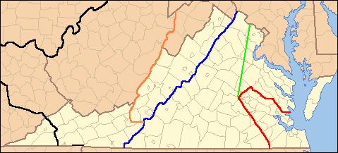
English: Lines show legal treaty frontiers between Virginia Colony and Indian Nations in various years. Red: Treaty of 1646. Green: Treaty of Albany (1684). Blue: Treaty of Albany (1722). Orange: Proclamation of 1763. Black: Treaty of Camp Charlotte (1774). Area west of this line in present-day Southwest VA was ceded by the Cherokee in 1775. |
| Data | (UTC) (Uploaded on Commons at 2012-01-07 00:14:24 (UTC)/Originally uploaded at 2009-07-23 14:00:15) |
| Fonte | I (Til Eulenspiegel (talk)) created this work entirely by myself. (Originally uploaded on en.wikipedia) |
| Autore | Til Eulenspiegel (talk) (Transferred by Grondemar/Originally uploaded by Til Eulenspiegel) |
| Altre versioni | en:File:VaFrontier.jpg, does not include the 1774 frontier (black line on map) |
Licenza
| Quest'opera è stata rilasciata nel pubblico dominio dal suo autore, Til Eulenspiegel. Questa norma si applica in tutto il mondo. In alcuni paesi questo potrebbe non essere legalmente possibile. In tal caso: |
Registro originale del caricamento
La pagina di descrizione originale era qui. Tutti i nomi utente che seguono sono riferiti a en.wikipedia.
Upload date | User | Bytes | Dimensions | Comment
- 2009-07-23 14:00:15 | Til Eulenspiegel | 27476 | 479×217 | {{Information |Description = Lines show legal treaty frontiers between Virginia Colony and Indian Nations in various years. Red: Treaty of 1646. Green: Treaty of Albany (1684). Blue: Treaty of Albany (1722). Orange: Proclamation of 1763. Black: Trea
Cronologia del file
Fare clic su un gruppo data/ora per vedere il file come si presentava nel momento indicato.
| Data/Ora | Miniatura | Dimensioni | Utente | Commento | |
|---|---|---|---|---|---|
| attuale | 02:14, 7 gen 2012 | | 479 × 217 (27 KB) | Grondemar | {{Information |Description ={{en|1=xxxxx}} |Source =xxxxx |Author =xxxxx |Date =xxxxx |Permission =xxxxx |other_versions =xxxxx }} xxxxx |
Pagine che usano questo file
Le seguenti 3 pagine usano questo file:
Utilizzo globale del file
Anche i seguenti wiki usano questo file:
- Usato nelle seguenti pagine di en.wikipedia.org:
- Usato nelle seguenti pagine di hy.wikipedia.org: