File:Titanicmap.png
Vai alla navigazione
Vai alla ricerca
Non sono disponibili versioni a risoluzione più elevata.
Titanicmap.png (431 × 179 pixel, dimensione del file: 3 KB, tipo MIME: image/png)
| Questo file e la sua pagina di descrizione (discussione · modifica) si trovano su Wikimedia Commons (?) |
Dettagli
כוהל
Licenza

|
È permesso copiare, distribuire e/o modificare questo documento in base ai termini della GNU Free Documentation License, Versione 1.2 o successive pubblicata dalla Free Software Foundation; senza alcuna sezione non modificabile, senza testo di copertina e senza testo di quarta di copertina. Una copia della licenza è inclusa nella sezione intitolata Testo della GNU Free Documentation License. |
| Questo file è disponibile in base alla licenza Creative Commons Attribuzione-Condividi allo stesso modo 3.0 Unported | ||
| ||
| Questo tag di copyright è stato aggiunto nell'ambito dell'aggiornamento della licenza dei progetti Wikimedia. |

|
Questa immagine (categorizzazione automatica: incident map) o tutte le immagini in questa categoria o galleria dovrebbero essere ricreate usando grafica vettoriale come file SVG. Questo offre diversi vantaggi: vedi Commons:Media for cleanup per maggiori informazioni. Se è disponibile una versione in formato SVG di questa immagine, per favore caricala. Dopo aver caricato un file SVG, sostituisci questo avviso con il template {{Vector version available|nome_immagine.svg}}.
|
Cronologia del file
Fare clic su un gruppo data/ora per vedere il file come si presentava nel momento indicato.
| Data/Ora | Miniatura | Dimensioni | Utente | Commento | |
|---|---|---|---|---|---|
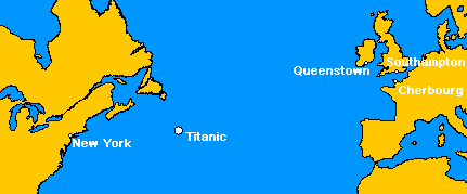
| attuale | 06:20, 17 mag 2005 | | 431 × 179 (3 KB) | MechBrowman~commonswiki | ({{GFDL}} This image was created by User:MechBrowman using http://www.aquarius.geomar.de/omc/ and Paint Shop Pro. It marks the location where the RMS Titanic sank on April 15, 1912. It also marks the ports of Southampton, Cherbourg, Queenstown, and N |
| 06:10, 17 mag 2005 |  | 431 × 179 (3 KB) | MechBrowman~commonswiki | ({{GFDL}} This image was created by User:MechBrowman using [http://www.aquarius.geomar.de/omc/] and Paint Shop Pro. It marks the location where the RMS Titanic sank on April 15, 1912. It also marks the ports of Southampton, Cherbourg, Queenstown, and |
Pagine che usano questo file
Nessuna pagina utilizza questo file.
Utilizzo globale del file
Anche i seguenti wiki usano questo file:
- Usato nelle seguenti pagine di da.wikipedia.org:
- Usato nelle seguenti pagine di en.wikipedia.org:
- Usato nelle seguenti pagine di et.wikipedia.org:
- Usato nelle seguenti pagine di ja.wikipedia.org:
- Usato nelle seguenti pagine di ko.wikipedia.org:
- Usato nelle seguenti pagine di lt.wikipedia.org:
- Usato nelle seguenti pagine di ms.wikipedia.org:
- Usato nelle seguenti pagine di ta.wikipedia.org: