File:Santiam Pass.jpg

File originale (2 272 × 1 514 pixel, dimensione del file: 1,86 MB, tipo MIME: image/jpeg)
| Questo file e la sua pagina di descrizione (discussione · modifica) si trovano su Wikimedia Commons (?) |
|
Questa è un'immagine di un luogo o edificio che è elencato nel National Register of Historic Places negli Stati Uniti. Il suo numero di riferimento è [https://npgallery.nps.gov/AssetDetail/NRIS/99001285
. 99001285
.]. |
| Descrizione |
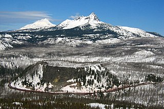
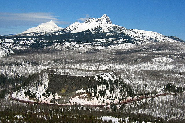
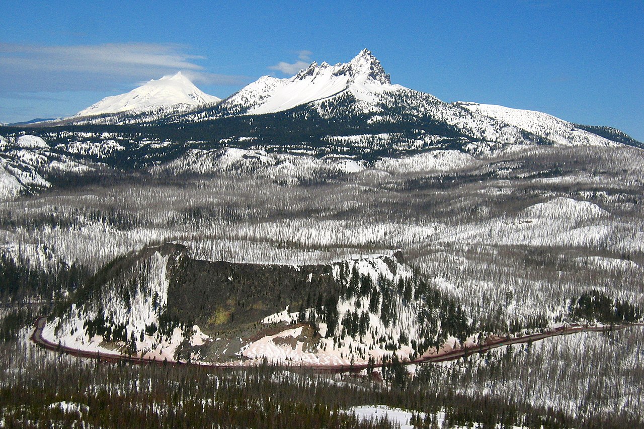
This is the majestic Santiam Pass, elevated at. 4817 ft above sea level in central Oregon Cascades. It is located about 18 mi (29 km) northwest of Sisters, between volcanic peaks of Three Fingered Jack to the north and Mount Washington to the south. U.S. Highway 20 connects eastern Oregon with the valley of the Santiam River on the west via Santiam Pass. One of the 19 or 20 lakes by the name of Lost Lake is located beside the highway just west of Santiam Pass. While the pass was known by native peoples, the first recorded crossing of the pass was in April 1859 by an expedition searching for a cattle trail over the Cascade Range from the Willamette Valley to Central Oregon. This expedition was led by Andrew Wiley, who reportedly climbed a tall tree on a mountain near Lost Prairie to help determine the route. Lost Prairie is located along Hackleman Creek between Fish Lake and Tombstone Prairie. Wiley later helped establish the Santiam Wagon Road. The prominent glaciated peak on the photo is the Three Fingered Jack, a Pleistocene volcano elevated 7,841 foot (2,390 meter), deeply glaciated and consists mainly of basaltic andesite lava. Mount Jefferson can also be seen from its left. The typical tuya volcano Hogg Rock, which is clearly visible from the photo below the Three Fingered Jack where US 20 Highway wraps in a nearly 180-degree curve below cliffs on the south and west sides, is only about 2 miles (3 km) north of Hayrick Butte, a somewhat larger tuya of similar age and composition. A tuya is a type of subglacial volcano, formed when lava erupts underneath an overlying glacier or ice sheet and then melts through to the surface and pools, producing the flat plateau on top with near-vertical walls along the ice-contact margin as the lava cools and hardens. Unlike most tuyas which have steep cliffs on all sides, Hogg Rock has a break in its cliffs on the east side, with a moderate slope which leads down to a small road and gravel pit. Santiam Pass was also the intended route over the Cascades for the Oregon Pacific Railroad, an early transcontinental railroad project led by Col. T. Egenton Hogg for whom Hogg Rock is named. Although the working line never extended east of Santiam Pass, the pass is today the eastern terminus of the Oregon Pacific Railroad Linear Historic District, which is listed on the US National Register of Historic Places. Taken from Hoodoo Ski Bowl summit. |
| Data | |
| Fonte | santiam pass |
| Autore | Shaun Che from Oregon, US |
| Posizione del soggetto | | Posizione di questa e altre immagini su: OpenStreetMap |
|---|
Licenza
- Tu sei libero:
- di condividere – di copiare, distribuire e trasmettere quest'opera
- di modificare – di adattare l'opera
- Alle seguenti condizioni:
- attribuzione – Devi fornire i crediti appropriati, un collegamento alla licenza e indicare se sono state apportate modifiche. Puoi farlo in qualsiasi modo ragionevole, ma non in alcun modo che suggerisca che il licenziante approvi te o il tuo uso.
| Questa immagine, originariamente caricata su Flickr, è stata controllata in data March 14, 2009 dall'amministratore o reviewer File Upload Bot (Magnus Manske), il quale ha confermato che, a quella data, l'immagine era disponibile su Flickr sotto la licenza indicata. |
| Annotazioni | Questa immagine è annotata: Vedi le annotazioni su Commons |
Cronologia del file
Fare clic su un gruppo data/ora per vedere il file come si presentava nel momento indicato.
| Data/Ora | Miniatura | Dimensioni | Utente | Commento | |
|---|---|---|---|---|---|
| attuale | 08:29, 14 mar 2009 | | 2 272 × 1 514 (1,86 MB) | File Upload Bot (Magnus Manske) | {{Information |Description= This is the majestic [http://en.wikipedia.org/wiki/Santiam_Pass Santiam Pass], elevated at. 4817 ft above sea level in central Oregon Cascades. It is located about 18 mi (29 km) northwest of Sisters, between volcanic peaks of |
Pagine che usano questo file
Le seguenti 2 pagine usano questo file:
Utilizzo globale del file
Anche i seguenti wiki usano questo file:
- Usato nelle seguenti pagine di en.wikipedia.org:
- Usato nelle seguenti pagine di es.wikipedia.org:
- Usato nelle seguenti pagine di fr.wikipedia.org:
- Usato nelle seguenti pagine di id.wikipedia.org:
- Usato nelle seguenti pagine di pt.wikipedia.org:
- Usato nelle seguenti pagine di uk.wikipedia.org:
- Usato nelle seguenti pagine di www.wikidata.org:
- Usato nelle seguenti pagine di zh.wikipedia.org: