File:Palace and Gardens of Schönbrunn rough map 2008.gif

File originale (780 × 840 pixel, dimensione del file: 27 KB, tipo MIME: image/gif)
| Questo file e la sua pagina di descrizione (discussione · modifica) si trovano su Wikimedia Commons (?) |
Note:
Please do not yet convert thisone to svg, as it still might contain an error. [w.] 09:30, 13 January 2009 (UTC)
| Descrizione |
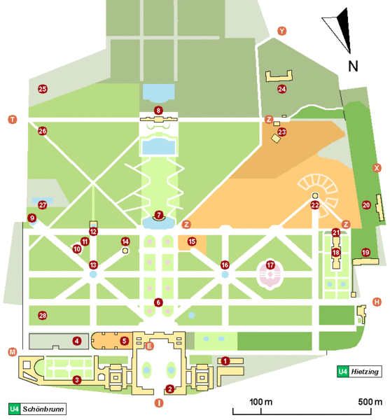
Schönbrunn (Vienna) palace and gardens map As of now, the characters and numbers mean the following:
(1) - 'Wagenburg', ehemalige Winterreitschule, jetzt Museum für Kutschen - 'Wagenburg', a carriage museum. (9) - Obeliskbrunnen - Obelisk Fountain. (22) - Zoo und 'Kaiserpavillion' - world's eldest existing zoo, with 'Emperor's pavilion' (now a Café). (23) - 'Tirolerhaus' und 'Tiroler Garten', now part of the zoo. 'Tirolerhaus' restaurant is outside the zoo. Side entrance to zoo (open temporarily). (24) - Bundesforschungs- und Ausbildungszentrum für Wald, Naturgefahren und Landschaft (BFW) - Federal Research and Training Centre for Forests, Natural Hazards and Landscape - formerly Forstliche Bundes-Versuchsanstalt (FBVA) (25) - Höhere Bundeslehr- und Versuchsanstalt für Gartenbau (26) - 'Kleine Gloriette' - 'Little Gloriette' (27) - 'Schönbrunner Bad' (a public swimming pool). (28) - 'Meierei', now a restaurant. |
| Data | |
| Fonte | Opera propria |
| Autore | Wolfgang H. Wögerer, Wien |
| Licenza (Riusare questo file) |
Io, detentore del copyright su quest'opera, dichiaro di pubblicarla con la seguente licenza: Questo file è disponibile in base alla licenza Creative Commons Attribuzione-Condividi allo stesso modo 3.0 Unported
|
| Annotazioni | Questa immagine è annotata: Vedi le annotazioni su Commons |


Cronologia del file
Fare clic su un gruppo data/ora per vedere il file come si presentava nel momento indicato.
| Data/Ora | Miniatura | Dimensioni | Utente | Commento | |
|---|---|---|---|---|---|
| attuale | 16:05, 20 mar 2008 | | 780 × 840 (27 KB) | W. | |
| 21:00, 27 feb 2008 |  | 780 × 840 (25 KB) | W. | ||
| 16:59, 26 feb 2008 |  | 780 × 820 (25 KB) | W. | ||
| 19:17, 19 feb 2008 |  | 800 × 850 (23 KB) | W. | {{Information= Schönbrunn (Vienna) palace and gardens rough map. This map tries to show buildings of major public interest, monuments, garden partions, alleys and the main entrances used by visitors. It was created by trying to merge officially available |
Pagine che usano questo file
La seguente pagina usa questo file:
Utilizzo globale del file
Anche i seguenti wiki usano questo file:
- Usato nelle seguenti pagine di de.wikipedia.org:
- Usato nelle seguenti pagine di de.wikiversity.org:
- Usato nelle seguenti pagine di de.wikivoyage.org:
- Usato nelle seguenti pagine di en.wikipedia.org:
- Usato nelle seguenti pagine di fa.wikipedia.org:
- Usato nelle seguenti pagine di fr.wikipedia.org:
- Usato nelle seguenti pagine di hr.wikipedia.org:
- Usato nelle seguenti pagine di hu.wikipedia.org:
- Usato nelle seguenti pagine di ja.wikipedia.org:
- Usato nelle seguenti pagine di mk.wikipedia.org:
- Usato nelle seguenti pagine di mt.wikipedia.org:
- Usato nelle seguenti pagine di pa.wikipedia.org:
- Usato nelle seguenti pagine di ru.wikipedia.org:
- Usato nelle seguenti pagine di sh.wikipedia.org:
- Usato nelle seguenti pagine di sv.wikipedia.org:
- Usato nelle seguenti pagine di th.wikipedia.org:
- Usato nelle seguenti pagine di vi.wikipedia.org: