File:Overtoun Bridge - geograph.org.uk - 1024544.jpg
Overtoun_Bridge_-_geograph.org.uk_-_1024544.jpg (640 × 480 pixel, dimensione del file: 110 KB, tipo MIME: image/jpeg)
| Questo file e la sua pagina di descrizione (discussione · modifica) si trovano su Wikimedia Commons (?) |
Dettagli
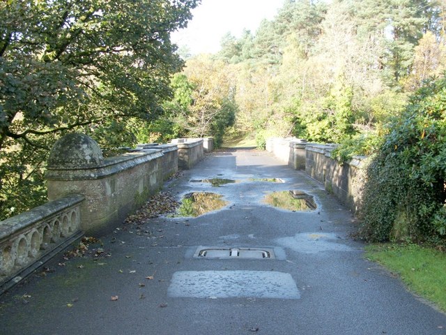
| Descrizione |
English: Overtoun Bridge. This thick-sided stone bridge, located next to 59380, has parapets on both sides; the river gorge that it crosses has sides that fall away steeply, and the river is therefore located a surprising distance below the bridge.
Overtoun House was built in 1859-63 for the Rutherglen chemical manufacturer James White (1735631), whose son became the first Lord Overtoun, but the bridge dates from 1895, and was built by H.E.Milner ["North Clyde Estuary - An Illustrated Architectural Guide", Frank Arneil Walker with Fiona Sinclair]. Although his son, John Campbell White (the aforementioned Lord Overtoun), was well known for his charitable works, he was famously lambasted in 1899 by Keir Hardie, who exposed the appalling working conditions faced by those employed in his chemical factory. [The location has featured in news reports more than once. In 1994, a mentally-disturbed man threw his two-week-old son to his death from the bridge. In October 2006, the fact that a surprising number of dogs have leapt to their death from the bridge was the subject of a television programme. This phenomenon has been reported under the sensational and misleading title of "dog suicides". Suggested explanations have ranged from the supernatural to peculiar sonic effects in the structure of the bridge; however, among the more plausible explanations is the idea that something (perhaps the scent of mink) is tempting dogs, from whose viewpoint the long drop is not apparent, to leap the bridge wall.] |
| Data | |
| Fonte | From geograph.org.uk |
| Autore | Lairich Rig |
| Attribuzione (richiesto dalla licenza) | Lairich Rig / Overtoun Bridge / |
| Luogo dello scatto | | Posizione di questa e altre immagini su: OpenStreetMap |
|---|
_heading:292.00&language=it)
| Posizione del soggetto | | Posizione di questa e altre immagini su: OpenStreetMap |
|---|
_heading:292.00&language=it)
Licenza

|
Questa immagine proviene dalla collezione del progetto Geograph. Vedi questa fotografia sul sito web di Geograph per visualizzare i dettagli relativi al fotografo. Il copyright di questa immagine appartiene a Lairich Rig ed è pubblicata secondo i termini della licenza Creative Commons Attribuzione-Condividi allo stesso modo 2.0.
|
- Tu sei libero:
- di condividere – di copiare, distribuire e trasmettere quest'opera
- di modificare – di adattare l'opera
- Alle seguenti condizioni:
- attribuzione – Devi fornire i crediti appropriati, un collegamento alla licenza e indicare se sono state apportate modifiche. Puoi farlo in qualsiasi modo ragionevole, ma non in alcun modo che suggerisca che il licenziante approvi te o il tuo uso.
- condividi allo stesso modo – Se remixi, trasformi o sviluppi il materiale, devi distribuire i tuoi contributi in base alla stessa licenza o compatibile all'originale.
Cronologia del file
Fare clic su un gruppo data/ora per vedere il file come si presentava nel momento indicato.
| Data/Ora | Miniatura | Dimensioni | Utente | Commento | |
|---|---|---|---|---|---|
| attuale | 16:58, 23 feb 2011 | | 640 × 480 (110 KB) | GeographBot | == {{int:filedesc}} == {{Information |description={{en|1=Overtoun Bridge This thick-sided stone bridge, located next to 59380, has parapets on both sides; the river gorge that it crosses has sides that fall away steeply, and the river is therefore loc |
Pagine che usano questo file
La seguente pagina usa questo file:
Utilizzo globale del file
Anche i seguenti wiki usano questo file:
- Usato nelle seguenti pagine di de.wikipedia.org:
- Usato nelle seguenti pagine di fa.wikipedia.org:
- Usato nelle seguenti pagine di fr.wikipedia.org:
- Usato nelle seguenti pagine di hy.wikipedia.org:
- Usato nelle seguenti pagine di ru.wikipedia.org:
- Usato nelle seguenti pagine di uk.wikipedia.org:
- Usato nelle seguenti pagine di www.wikidata.org:
- Usato nelle seguenti pagine di zh.wikipedia.org: