File:ORD airport map.PNG
Vai alla navigazione
Vai alla ricerca

Dimensioni di questa anteprima: 391 × 600 pixel. Altre risoluzioni: 156 × 240 pixel | 313 × 480 pixel | 807 × 1 238 pixel.
File originale (807 × 1 238 pixel, dimensione del file: 247 KB, tipo MIME: image/png)
| Questo file e la sua pagina di descrizione (discussione · modifica) si trovano su Wikimedia Commons (?) |

|
File:ORD Airport Diagram.svg è una versione vettoriale di questo file. Dovrebbe essere usata quella versione al posto di questo file PNG, quando sia migliore.
File:ORD airport map.PNG → File:ORD Airport Diagram.svg
Per maggiori informazioni, vedi Help:SVG. |
 |

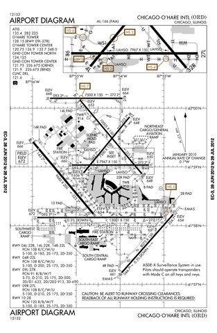
Airport diagram of O'Hare International Airport
Questo file è opera di un dipendente della Federal Aviation Administration ed è stato creato durante l'assolvimento dei suoi doveri ufficiali. Come lavoro del Governo federale degli Stati Uniti d'America, il file è nel pubblico dominio.
|
 |
Cronologia del file
Fare clic su un gruppo data/ora per vedere il file come si presentava nel momento indicato.
| Data/Ora | Miniatura | Dimensioni | Utente | Commento | |
|---|---|---|---|---|---|
| attuale | 00:50, 13 lug 2012 | | 807 × 1 238 (247 KB) | Phongn | Update to 28 Jun 2012 version. |
| 03:59, 24 ott 2010 |  | 807 × 1 238 (306 KB) | Mareklug | Reverted to version as of 01:52, 24 October 2010 | |
| 03:58, 24 ott 2010 |  | 807 × 1 238 (306 KB) | Mareklug | newer, 2nd attempt. | |
| 03:52, 24 ott 2010 |  | 807 × 1 238 (306 KB) | Mareklug | newer, larger version (Oct 21, 2010) | |
| 18:40, 7 mag 2010 |  | 387 × 594 (98 KB) | Spartan S58 | Showing the shortening of 32L'14R, and changed taxi from P to U. | |
| 01:59, 19 feb 2009 |  | 774 × 1 188 (129 KB) | Mahahahaneapneap | Compressed | |
| 05:54, 11 dic 2008 |  | 774 × 1 188 (257 KB) | Jalentz | Updated to include opening of runway 9L/27R November 2008 | |
| 21:33, 22 lug 2007 |  | 1 570 × 2 285 (305 KB) | Mareklug | Updated (version from 5 July 2007 showing redesignated runway 10/28 which used to be 9R/27L) airport diagram of O'Hare International Airport {{PD-USGov-FAA}} | |
| 23:15, 6 gen 2006 |  | 733 × 1 133 (134 KB) | Cmprince | Aiport diagram of O'Hare International Airport {{PD-USGov-FAA}} |
Pagine che usano questo file
Nessuna pagina utilizza questo file.