File:New York Harbor Nautical Chart.jpg

File originale (906 × 595 pixel, dimensione del file: 172 KB, tipo MIME: image/jpeg)
| Questo file e la sua pagina di descrizione (discussione · modifica) si trovano su Wikimedia Commons (?) |
Dettagli
| Descrizione |
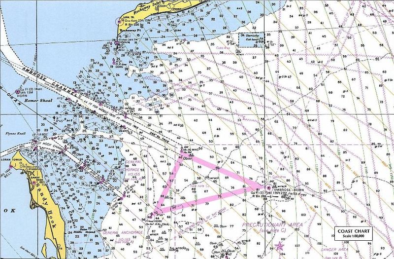
Nautical chart including LORAN TD lines for ocean approaches to New York Harbor. The chart shows TD lines, apparently for LORAN-A, which would make it the Nantucket-Chatam-Montuck-Sandy Hook-Fenwick-Bodie Is-Cape Hatteras chain. Note that the printed TD lines do not extend into inland waterway areas, as LORAN propagates poorly over land. The green 1000 lines curve heavily in this area. Note the "LORAN TR" mark at the tip of Sandy Hook near the focus of the curves. This would be Station "J" (3H5). The ochre 4000 lines (3H4) would correspond to the TD between the master and Station "H" at Cape Hatteras. The master station of this chain was at Sankaty Head on Nantucket, Massachussets. [1] The sharp angle between these sets of TD rings, especially to the east and north, would make it a poor pair for precise navigation. This is a detail of the original at:
|
| Data | 18 dicembre 2004 (data di caricamento originaria) |
| Fonte |
Perry-Castañeda Map Collection, University of Texas at Austin - Original URL (detail) - Copyright statement Originally uploaded on en.wikipedia; the description page was written by User:KeithTyler, and imported from here. |
| Autore | Sconosciuto |
| Licenza (Riusare questo file) |
PD-LAYOUT; PD-USGOV. |
![[2]](http://www.lib.utexas.edu/maps/national_atlas_1970/ca000219.jpg)
Licenza
Quest'opera è nel pubblico dominio negli Stati Uniti d'America poiché è opera del Governo Federale degli Stati Uniti secondo i termini del titolo 17, capitolo 1, sezione 105 del Codice USA. Vedi anche Copyright per maggiori informazioni.
Nota: la norma si applica solo ad opere prodotte dal governo federale e non dai singoli stati, territori, commonwealth, contee, suddivisioni, municipalità o qualsiasi altra suddivisione degli Stati Uniti. Non si applica inoltre ai francobolli pubblicati dallo United States Postal Service fino al 1978 (vedi 206.02(b) of Compendium II: Copyright Office Practices).
|
 | |
| Questo file è stato identificato come libero da restrizioni conosciute riguardanti le leggi sul copyright, compresi tutti i diritti connessi e vicini. | ||
Cronologia del file
Fare clic su un gruppo data/ora per vedere il file come si presentava nel momento indicato.
| Data/Ora | Miniatura | Dimensioni | Utente | Commento | |
|---|---|---|---|---|---|
| attuale | 12:12, 14 lug 2007 | | 906 × 595 (172 KB) | Massimiliano Lincetto | {{Information |Description=Nautical chart including en:LORAN TD lines for ocean approaches to New York Harbor. The chart shows TD lines, apparently for LORAN-A, which would make it the NANTUCKET-CHATHAM-MONTUCK-SANDY HOOK-FENWICK-BODIE IS-CAPE HATTE |
Pagine che usano questo file
La seguente pagina usa questo file:
Utilizzo globale del file
Anche i seguenti wiki usano questo file:
- Usato nelle seguenti pagine di en.wikipedia.org:
- Usato nelle seguenti pagine di fr.wikipedia.org:
- Usato nelle seguenti pagine di lv.wikipedia.org:
- Usato nelle seguenti pagine di nl.wikipedia.org:
- Usato nelle seguenti pagine di ru.wikipedia.org:
- Usato nelle seguenti pagine di sl.wikipedia.org:
- Usato nelle seguenti pagine di vi.wikipedia.org: