File proveniente da Wikimedia Commons. Clicca per visitare la pagina originale

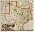
File:Map of the Gulf, Colorado and Santa Fe 'Texas Midland Route' 1880 UTA.jpg

Da Wikipedia, l'enciclopedia libera.
Vai alla navigazione Vai alla ricerca

File originale(9 230 × 8 592 pixel, dimensione del file: 13,64 MB, tipo MIME: image/jpeg)

Logo di Commons
Logo di Commons
Questo file e la sua pagina di descrizione (discussione · modifica) si trovano su Wikimedia Commons (?)

Dettagli

Attenzione Alcuni browser potrebbero avere dei problemi nel mostrare questa immagine a piena risoluzione: questa immagine è composta da un numero insolitamente alto di pixel e potrebbe non essere visualizzata correttamente o causare l'arresto del browser.
Titolo
English: Gulf, Colorado and Santa Fe Railway and Connections. The "Texas Midland Route".
Descrizione
English: This promotional map of Texas, Indian Territory, and parts of surrounding states is quite unusual in its almost fluorescent coloration. The text on the back of the map advertises "300 miles of track" and "better and surer connections" with trains of the International and Great Northern Railroad. Since the G.C. & S.F. wanted to promote this relationship, the map shows those lines thicker, although not as thick as the G.C.& S.F. itself. Not surprisingly, the thinner lines are reserved for the main competitor railroad: the Houston & Texas Central.
Data circa
date QS:P,+1880-00-00T00:00:00Z/9,P1480,Q5727902
Fonte UTA Libraries Cartographic Connections: mappa / testo
Creatore
Woodward, Tiernan & Hale et al.
Attribuzione
English: The University of Texas at Arlington Libraries Special Collections
 Geotemporal data
Map location Texas
Georeferencing Georeference the map in Wikimaps Warper If inappropriate please set warp_status = skip to hide.
 Bibliographic data
Luogo di pubblicazione Galveston
Casa editrice
Gulf, Colorado and Santa Fe Railway
Stampato da
Woodward, Tiernan & Hale, Saint Louis
 Archival data
institution QS:P195,Q1230739
Dimensioni altezza: 47 cm; larghezza: 51,5 cm
dimensions QS:P2048,47U174728
dimensions QS:P2049,51.5U174728
Tecnica/materiale cerograph a colori
cromolitografia
medium QS:P186,Q1121337


Licenza

Public domain
This work was published before January 1, 1929 and it is anonymous or pseudonymous due to unknown authorship. It is in the public domain in the United States as well as countries and areas where the copyright terms of anonymous or pseudonymous works are 95 years or fewer since publication.

Didascalie

Aggiungi una brevissima spiegazione di ciò che questo file rappresenta

Elementi ritratti in questo file

raffigura

image/jpeg

Cronologia del file

Fare clic su un gruppo data/ora per vedere il file come si presentava nel momento indicato.

Data/OraMiniaturaDimensioniUtenteCommento
attuale20:15, 6 apr 2022Miniatura della versione delle 20:15, 6 apr 20229 230 × 8 592 (13,64 MB)Michael Barera== {{int:filedesc}} == {{Map |title = {{en|'''''Gulf, Colorado and Santa Fe Railway and Connections. The "Texas Midland Route".'''''}} |description = {{en|This promotional map of Texas, Indian Territory, and parts of surrounding states is quite unusual in its almost fluorescent coloration. The text on the back of the map advertises "300 miles of track" and "better and surer connections" with trains of the International and Great Northern Railroad. Since the G.C. & S.F. wan...

La seguente pagina usa questo file:

Utilizzo globale del file

Anche i seguenti wiki usano questo file:

Metadati