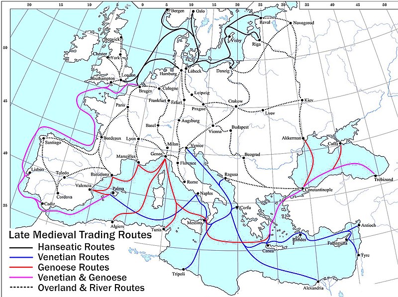
File:Late Medieval Trade Routes.jpg
Vai alla navigazione
Vai alla ricerca

Dimensioni di questa anteprima: 800 × 597 pixel. Altre risoluzioni: 320 × 239 pixel | 640 × 478 pixel | 1 024 × 765 pixel | 1 280 × 956 pixel | 1 457 × 1 088 pixel.
File originale (1 457 × 1 088 pixel, dimensione del file: 372 KB, tipo MIME: image/jpeg)
Cronologia del file
Fare clic su un gruppo data/ora per vedere il file come si presentava nel momento indicato.
| Data/Ora | Miniatura | Dimensioni | Utente | Commento | |
|---|---|---|---|---|---|
| attuale | 22:46, 18 mag 2022 |  | 1 457 × 1 088 (372 KB) | Richard2s | Clearer key for map |
| 22:25, 23 gen 2011 |  | 853 × 544 (453 KB) | Micsha~commonswiki | Includes map key on the map | |
| 17:55, 28 mar 2008 |  | 1 817 × 1 120 (487 KB) | Lampman | {{Information |Description=Map showing the main trade routes of late medieval Europe. The black lines show the routes of the Hanseatic League, the blue Venetian and the red Genoese routes. Purple lines are routes used by both the Venetians and the Genoese |
Pagine che usano questo file
Le seguenti 2 pagine usano questo file:
Utilizzo globale del file
Anche i seguenti wiki usano questo file:
- Usato nelle seguenti pagine di ar.wikipedia.org:
- Usato nelle seguenti pagine di be-tarask.wikipedia.org:
- Usato nelle seguenti pagine di bg.wikipedia.org:
- Usato nelle seguenti pagine di ca.wikipedia.org:
- Usato nelle seguenti pagine di da.wikipedia.org:
- Usato nelle seguenti pagine di el.wikipedia.org:
- Usato nelle seguenti pagine di en.wikipedia.org:
- Usato nelle seguenti pagine di es.wikipedia.org:
- Usato nelle seguenti pagine di et.wikipedia.org:
- Usato nelle seguenti pagine di fr.wikipedia.org:
- Usato nelle seguenti pagine di he.wikipedia.org:
- Usato nelle seguenti pagine di hy.wikipedia.org:
- Usato nelle seguenti pagine di ja.wikipedia.org:
- Usato nelle seguenti pagine di mk.wikipedia.org:
- Usato nelle seguenti pagine di nl.wikipedia.org:
- Usato nelle seguenti pagine di pl.wikipedia.org:
- Usato nelle seguenti pagine di pt.wikipedia.org:
- Usato nelle seguenti pagine di rm.wikipedia.org:
- Usato nelle seguenti pagine di sh.wikipedia.org:
- Usato nelle seguenti pagine di sl.wikipedia.org:
- Usato nelle seguenti pagine di sq.wikipedia.org:
- Usato nelle seguenti pagine di uk.wikipedia.org:
- Usato nelle seguenti pagine di vi.wikipedia.org:
Visualizza l'utilizzo globale di questo file.


