File:Jylland overview map2.PNG
Vai alla navigazione
Vai alla ricerca

Dimensioni di questa anteprima: 332 × 600 pixel. Altre risoluzioni: 133 × 240 pixel | 266 × 480 pixel | 964 × 1 741 pixel.
File originale (964 × 1 741 pixel, dimensione del file: 171 KB, tipo MIME: image/png)
| Questo file e la sua pagina di descrizione (discussione · modifica) si trovano su Wikimedia Commons (?) |

|
Questa immagine (categorizzazione automatica: historical map) o tutte le immagini in questa categoria o galleria dovrebbero essere ricreate usando grafica vettoriale come file SVG. Questo offre diversi vantaggi: vedi Commons:Media for cleanup per maggiori informazioni. Se è disponibile una versione in formato SVG di questa immagine, per favore caricala. Dopo aver caricato un file SVG, sostituisci questo avviso con il template {{Vector version available|nome_immagine.svg}}.
|
Dettagli
| Descrizione |
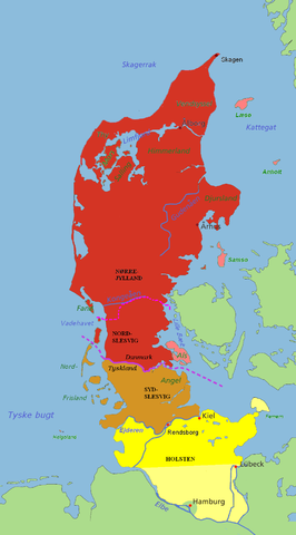
Jutland and the Jutland Peninsula Red: Commonly defined as Jutland today, including the area north of the Limfjord and minor islands Pink: The islands of Læsø, Anholt, Samsø and Als are usually attributed to Jutland as well Brown: South Slesvig/Schleswig in the German state of Schleswig-Holstein, historically a part of Jutland Yellow: Holstein, situated on the Jutland Peninsula, but not in Jutland itself. The river Kongeå is the historical border between Northern and Southern Jutland (Slesvig). The river Eider is the historical southern border of Jutland (and formerly Denmark), and between Slesvig and Holstein. The city of Rendsburg and the island of Helgoland are sometimes regarded as Slesvig, sometimes not. The Jutland Peninsula as a geographic term has no fixed southern border, but at its furthest it would stretch to the river Elbe. Hamburg, however, is not a part of Holstein, and Lübeck was not a part of Holstein until the 20th century. The Jutland Peninsula may also be called the Cimbrian Peninsula, Jutland-Holstein or Jutland-Schleswig-Holstein. |
| Data | |
| Fonte | self-made / edited from original map by Astrokey44 (GFDL). |
| Autore | Casper |
Licenza
I, Casper, detentore del copyright su quest'opera, dichiara di pubblicarla con le seguenti licenze:

|
È permesso copiare, distribuire e/o modificare questo documento in base ai termini della GNU Free Documentation License, Versione 1.2 o successive pubblicata dalla Free Software Foundation; senza alcuna sezione non modificabile, senza testo di copertina e senza testo di quarta di copertina. Una copia della licenza è inclusa nella sezione intitolata Testo della GNU Free Documentation License. |
| Questo file è disponibile in base alla licenza Creative Commons Attribuzione-Condividi allo stesso modo 3.0 Unported | ||
| Attribuzione: I, Casper | ||
| ||
| Questo tag di copyright è stato aggiunto nell'ambito dell'aggiornamento della licenza dei progetti Wikimedia. |
Questo file è disponibile in base alle licenze Creative Commons Attribuzione-Condividi allo stesso modo 2.5 Generico, 2.0 Generico e 1.0 Generico
Attribuzione: I, Casper
- Tu sei libero:
- di condividere – di copiare, distribuire e trasmettere quest'opera
- di modificare – di adattare l'opera
- Alle seguenti condizioni:
- attribuzione – Devi fornire i crediti appropriati, un collegamento alla licenza e indicare se sono state apportate modifiche. Puoi farlo in qualsiasi modo ragionevole, ma non in alcun modo che suggerisca che il licenziante approvi te o il tuo uso.
- condividi allo stesso modo – Se remixi, trasformi o sviluppi il materiale, devi distribuire i tuoi contributi in base alla stessa licenza o compatibile all'originale.
Puoi scegliere la licenza che preferisci.
Cronologia del file
Fare clic su un gruppo data/ora per vedere il file come si presentava nel momento indicato.
| Data/Ora | Miniatura | Dimensioni | Utente | Commento | |
|---|---|---|---|---|---|
| attuale | 05:03, 10 lug 2007 | | 964 × 1 741 (171 KB) | Casper~commonswiki | == Summary == {{Information |Description='''Jutland and the Jutland Peninsula'''<br><br>'''Red:''' Commonly defined as Jutland today, including the area north of the Limfjord and minor islands<br>'''Pink:''' The islands of Læsø, Anholt, Samsø and Als a |
Pagine che usano questo file
La seguente pagina usa questo file:
Utilizzo globale del file
Anche i seguenti wiki usano questo file:
- Usato nelle seguenti pagine di be.wikipedia.org:
- Usato nelle seguenti pagine di ca.wikipedia.org:
- Usato nelle seguenti pagine di ceb.wikipedia.org:
- Usato nelle seguenti pagine di cy.wikipedia.org:
- Usato nelle seguenti pagine di da.wikipedia.org:
- Usato nelle seguenti pagine di en.wikipedia.org:
- Usato nelle seguenti pagine di es.wikipedia.org:
- Usato nelle seguenti pagine di fa.wikipedia.org:
- Usato nelle seguenti pagine di fr.wikipedia.org:
- Usato nelle seguenti pagine di ko.wikipedia.org:
- Usato nelle seguenti pagine di nn.wikipedia.org:
- Usato nelle seguenti pagine di no.wikipedia.org:
- Usato nelle seguenti pagine di pt.wikipedia.org:
- Usato nelle seguenti pagine di ru.wikipedia.org:
- Usato nelle seguenti pagine di sv.wikipedia.org:
- Usato nelle seguenti pagine di vi.wikipedia.org:
- Usato nelle seguenti pagine di wa.wikipedia.org:
- Usato nelle seguenti pagine di www.wikidata.org: