File:Helsinki tram map.png
Vai alla navigazione
Vai alla ricerca

Dimensioni di questa anteprima: 600 × 600 pixel. Altre risoluzioni: 240 × 240 pixel | 480 × 480 pixel | 768 × 768 pixel | 1 200 × 1 200 pixel.
File originale (1 200 × 1 200 pixel, dimensione del file: 98 KB, tipo MIME: image/png)
| Questo file e la sua pagina di descrizione (discussione · modifica) si trovano su Wikimedia Commons (?) |
Dettagli
| Descrizione |
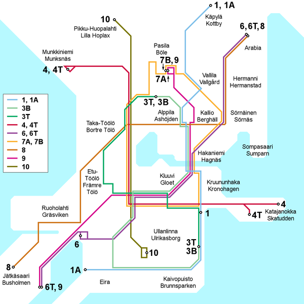
English: Map of the Helsinki tram network, current as of 30 March 2009. Place names in Finnish and Swedish. This file is being kept up to date (or at least attempted to) by Kjet.
Suomi: Kartta Helsingin raitiotieverkosta 30. maaliskuuta 2009 tilanteen mukaan. Paikannimet suomeksi ja ruotsiksi. Kjet pitää (tai ainakin yrittää pitää) tämän tiedoston ajantasalla.
Svenska: Kartan över Helsingfors spårvägslinjer, aktuell av 30 mars 2009. Namn på finska och svenska. Denna filet är uppdaterad av Kjet. |
| Data | |
| Fonte | Opera propria |
| Autore | Kjet |

|
Questa immagine (categorizzazione automatica: transport map) o tutte le immagini in questa categoria o galleria dovrebbero essere ricreate usando grafica vettoriale come file SVG. Questo offre diversi vantaggi: vedi Commons:Media for cleanup per maggiori informazioni. Se è disponibile una versione in formato SVG di questa immagine, per favore caricala. Dopo aver caricato un file SVG, sostituisci questo avviso con il template {{Vector version available|nome_immagine.svg}}.
|
Licenza
Io, detentore del copyright su quest'opera, dichiaro di pubblicarla con la seguente licenza:
Questo file è disponibile in base alla licenza Creative Commons Attribuzione 3.0 Unported
- Tu sei libero:
- di condividere – di copiare, distribuire e trasmettere quest'opera
- di modificare – di adattare l'opera
- Alle seguenti condizioni:
- attribuzione – Devi fornire i crediti appropriati, un collegamento alla licenza e indicare se sono state apportate modifiche. Puoi farlo in qualsiasi modo ragionevole, ma non in alcun modo che suggerisca che il licenziante approvi te o il tuo uso.
Cronologia del file
Fare clic su un gruppo data/ora per vedere il file come si presentava nel momento indicato.
| Data/Ora | Miniatura | Dimensioni | Utente | Commento | |
|---|---|---|---|---|---|
| attuale | 16:40, 3 feb 2013 | | 1 200 × 1 200 (98 KB) | Kjet | Updated with the autumn 2012 extension of line 9 and the new line 6T opened in January 2013. |
| 23:00, 11 lug 2012 |  | 1 200 × 1 200 (96 KB) | Kjet | Updated with the changed route of line 8 from 2012-01-01. Apologies for the delay. | |
| 11:22, 13 gen 2010 |  | 1 200 × 1 200 (96 KB) | Kjet | Corrected the accidentally reversed directions for lines 7A and 7B. | |
| 21:51, 29 mar 2009 |  | 1 200 × 1 200 (96 KB) | Kjet | {{Information |Description={{en|1=Map of the Helsinki tram network, current as of 30 March 2009. Place names in Finnish and Swedish. This file is being kept up to date (or at least attempted to) by Kjet.}} {{fi|1=Kartta Helsingin raitiotieve |
Pagine che usano questo file
La seguente pagina usa questo file:
Utilizzo globale del file
Anche i seguenti wiki usano questo file:
- Usato nelle seguenti pagine di en.wikipedia.org:
- Usato nelle seguenti pagine di es.wikivoyage.org:
- Usato nelle seguenti pagine di he.wikivoyage.org:
- Usato nelle seguenti pagine di ja.wikipedia.org:
- Usato nelle seguenti pagine di tr.wikipedia.org: