File:Wfm james ross straight.png
Vai alla navigazione
Vai alla ricerca

Dimensioni di questa anteprima: 800 × 593 pixel. Altre risoluzioni: 320 × 237 pixel | 640 × 474 pixel | 1 024 × 758 pixel | 1 280 × 948 pixel.
File originale (1 280 × 948 pixel, dimensione del file: 2,7 MB, tipo MIME: image/png)
| Questo file e la sua pagina di descrizione (discussione · modifica) si trovano su Wikimedia Commons (?) |
Dettagli
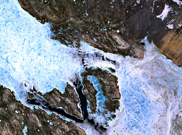
The James Ross Straight northeast of King William Island. Sea ice fills the straight, forming a bridge to Tennent Island (in the west) and Matty Island (further to the east).
NASA Landsat 7 satellite image, collected using NASA World Wind.
Licenza
| This image is in the public domain because it is a screenshot from NASA’s globe software World Wind using a public domain layer, such as Blue Marble, MODIS, Landsat, SRTM, USGS or GLOBE.
|
 |
Cronologia del file
Fare clic su un gruppo data/ora per vedere il file come si presentava nel momento indicato.
| Data/Ora | Miniatura | Dimensioni | Utente | Commento | |
|---|---|---|---|---|---|
| attuale | 20:38, 2 set 2005 | | 1 280 × 948 (2,7 MB) | Finlay McWalter | The James Ross Straight northeast of en:King William Island. Sea ice fills the straight, forming a bridge to Tennent Island (in the west) and Matty Island (further to the east). NASA Landsat 7 satellite image, collected using NASA World Wind. |
Pagine che usano questo file
La seguente pagina usa questo file:
Utilizzo globale del file
Anche i seguenti wiki usano questo file:
- Usato nelle seguenti pagine di bg.wikipedia.org:
- Usato nelle seguenti pagine di de.wikipedia.org:
- Usato nelle seguenti pagine di en.wikipedia.org:
- Usato nelle seguenti pagine di es.wikipedia.org:
- Usato nelle seguenti pagine di fi.wikipedia.org:
- Usato nelle seguenti pagine di fr.wikipedia.org:
- Usato nelle seguenti pagine di ja.wikipedia.org:
- Usato nelle seguenti pagine di ml.wikipedia.org:
- Usato nelle seguenti pagine di nl.wikipedia.org:
- Usato nelle seguenti pagine di pt.wikipedia.org:
- Usato nelle seguenti pagine di ru.wikipedia.org:
- Usato nelle seguenti pagine di zh.wikipedia.org: