File:Warming Island USGS Landsat.jpg
Vai alla navigazione
Vai alla ricerca
Non sono disponibili versioni a risoluzione più elevata.
Warming_Island_USGS_Landsat.jpg (800 × 262 pixel, dimensione del file: 56 KB, tipo MIME: image/jpeg)
| Questo file e la sua pagina di descrizione (discussione · modifica) si trovano su Wikimedia Commons (?) |
| Descrizione |
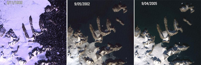
Warming Island, Greenland L5, L7 ETM+ Acquisition Date: Aug 11, 1985 & Sep 05, 2002 & Sep 04, 2005 Path/Row: 227/9 Lat/Long: 72.207/-22.180 On January 16th, 2007, the New York Times reported that a new island had been found in Greenland. Warming Island was once thought to be an ice-covered peninsula, but it was exposed as an island when a glacier melted to reveal the strait. This image shows satellite pictures of the island in 1985 when the glacier had firmly tied it to the mainland, in 2002 when there was only a thin bridge of ice, and in 2005 when the bridge of ice has broken to reveal an open water strait. More islands like this may be discovered if the Greenland ice sheet continues to disappear. |
| Data | tra il 1985 e il 2005 |
| Fonte |
|
| Autore | USGS Landsat |
| Licenza (Riusare questo file) |
PD-USGov-Interior-USGS |
Quest'immagine è nel pubblico dominio perché contiene materiale proveniente dallo United States Geological Survey, un'agenzia del Dipartimento degli Interni degli Stati Uniti. Per maggiori informazioni vedere la politica ufficiale dell'USGS sul copyright.
|
Cronologia del file
Fare clic su un gruppo data/ora per vedere il file come si presentava nel momento indicato.
| Data/Ora | Miniatura | Dimensioni | Utente | Commento | |
|---|---|---|---|---|---|
| attuale | 23:15, 3 dic 2008 | 800 × 262 (56 KB) | RaviC | {{Information |Description=Warming Island, Greenland L5, L7 ETM+ Acquisition Date: Aug 11, 1985 & Sep 05, 2002 & Sep 04, 2005 Path/Row: 227/9 Lat/Long: 72.207/-22.180 On January 16th, 2007, the New York Times reported that a new island had been found in |
Pagine che usano questo file
La seguente pagina usa questo file:
Utilizzo globale del file
Anche i seguenti wiki usano questo file:
- Usato nelle seguenti pagine di ar.wikipedia.org:
- Usato nelle seguenti pagine di az.wikipedia.org:
- Usato nelle seguenti pagine di en.wikipedia.org:
- Usato nelle seguenti pagine di es.wikipedia.org:
- Usato nelle seguenti pagine di hy.wikipedia.org:
- Usato nelle seguenti pagine di ja.wikipedia.org:
- Usato nelle seguenti pagine di nl.wikipedia.org:
- Usato nelle seguenti pagine di pl.wikipedia.org:
- Usato nelle seguenti pagine di ru.wikipedia.org:
- Usato nelle seguenti pagine di uk.wikipedia.org:
- Usato nelle seguenti pagine di vi.wikipedia.org: