File:Ukrania quae et Terra Cosaccorum cum vicinis Walachiae, Moldoviae, Johann Baptiste Homann (Nuremberg, 1720).jpg

File originale (7 000 × 5 793 pixel, dimensione del file: 5,32 MB, tipo MIME: image/jpeg)
| Questo file e la sua pagina di descrizione (discussione · modifica) si trovano su Wikimedia Commons (?) |
Dettagli
| Descrizione |
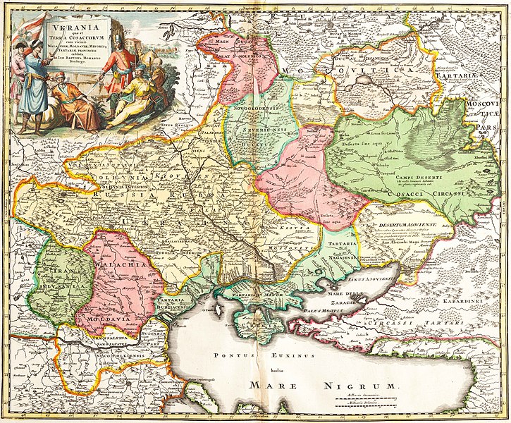
Українська: Ukrania quae et Terra Cosaccorum cum vicinis Walachiae, Moldoviae, Johann Baptiste Homann (Nuremberg, 1720) «Україна або козацька земля з прилеглими провінціями Валахії, Молдавії і Малої Татарії, зображена Йоганом-Баптистом Гоманном». |
|||||||||||||||||||||||
| Data | ||||||||||||||||||||||||
| Fonte | Vkraina | |||||||||||||||||||||||
| Autore |
|
|||||||||||||||||||||||
.jpg)
.jpg?uselang=it)
.jpg)
.jpg&action=edit)
Licenza
|
Quest'opera è nel pubblico dominio anche in tutti i Paesi e nelle aree in cui la durata del copyright è la vita dell'autore più 100 anni o meno. | |
| Questo file è stato identificato come libero da restrizioni conosciute riguardanti le leggi sul copyright, compresi tutti i diritti connessi e vicini. | |
Cronologia del file
Fare clic su un gruppo data/ora per vedere il file come si presentava nel momento indicato.
| Data/Ora | Miniatura | Dimensioni | Utente | Commento | |
|---|---|---|---|---|---|
| attuale | 23:12, 20 set 2021 | | 7 000 × 5 793 (5,32 MB) | Lanamy | Higher resolution |
| 17:00, 28 mag 2014 |  | 2 500 × 2 069 (3,29 MB) | VLebid | User created page with UploadWizard |
Pagine che usano questo file
Nessuna pagina utilizza questo file.
Utilizzo globale del file
Anche i seguenti wiki usano questo file:
- Usato nelle seguenti pagine di ar.wikipedia.org:
- Usato nelle seguenti pagine di be-tarask.wikipedia.org:
- Usato nelle seguenti pagine di bg.wikipedia.org:
- Usato nelle seguenti pagine di ca.wikipedia.org:
- República Socialista Soviètica d'Ucraïna
- Accident de Txornòbil
- Galítsia
- Bucovina
- Kanat de Crimea
- Front Oriental de la Segona Guerra Mundial
- Cosacs
- Imperi Rus
- Holodomor
- Rada Suprema
- Confederació de Polònia i Lituània
- Bandera d'Ucraïna
- Revolució Taronja
- Ucraïnesos
- President d'Ucraïna
- Gran Ducat de Lituània
- Llista de museus d'Ucraïna
- Literatura d'Ucraïna
- Petita Rússia
- Nova Rússia
- Rus de Kíev
- Invasió mongola de la Rus de Kíev
- Crisi del gas entre Ucraïna i Rússia
- Hetmanat cosac
- Principat de Galítsia-Volínia
- República Popular d'Ucraïna
- Història d'Ucraïna
- Tractat de Pereiàslav
- República Popular d'Ucraïna Occidental
- Directori d'Ucraïna
- Eslaus orientals
- Estat Ucraïnès
- Rus (poble)
- Zaporoges
- Organització dels nacionalistes ucraïnesos
- Marge dret d'Ucraïna
- Marge esquerre d'Ucraïna
- Euromaidan
- Relacions entre Ucraïna i la Unió Europea
- Constitució d'Ucraïna
- Crisi de Crimea
- Nacionalisme ucraïnès
- Massacre de polonesos a Volínia
- Rebel·lió de Khmelnitski
- Guerra al Donbàs
- Ucraïna Slobodà
- Consell de Ministres d'Ucraïna
Visualizza l'utilizzo globale di questo file.
.jpg)
.jpg)