File:St Blaise, Haccombe - geograph.org.uk - 825022.jpg

File originale (480 × 640 pixel, dimensione del file: 103 KB, tipo MIME: image/jpeg)
| Questo file e la sua pagina di descrizione (discussione · modifica) si trovano su Wikimedia Commons (?) |
Dettagli
| Descrizione |
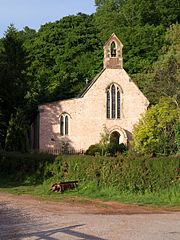
English: St Blaise, Haccombe A singular church, perhaps of as much interest as any other of its size, and possibly dating from 1233, certainly the C13. "The Rector of the church holds the rare title of Archpriest a privilege founded in medieval times and ratified in 1913 by King George V. This entitles him to wear lawn sleeves, like a bishop, and a fur stole, or amyss." (http://www.pbs.org.uk/news/index.asp ) (The more usual spelling would be "amice"). This title reflects the fact that the Archpriest has the right to sit beside the Bishop at ceremonies, and recognises no authority lower than the Archbishop of Canterbury.
The Amice is a rectangle of white linen worn as a neck-cloth or hood with the alb and other vestments at the Eucharist. Not to be confused with the Amyss or Almuce, which is as stated in the preceding paragraph a stole-like garment of animal fur, worn over the surplice by canons, archpriests and other dignitaries in lieu of the Tippet or Black Scarf at Mattins and Evensong. (Note by Hugh Allen, 30 April 2021) Reverend William Keble Martin, the artist of Concise British Flora fame, held the position of Archpriest here from 1921 to 1934. The church was praised by the Prayer Book Society in March 2008 for using only the 1662 Book of Common Prayer. The bell, dating from 1290, may be the oldest in Devon, and there are several remarkable monuments. |
| Data | |
| Fonte | From geograph.org.uk |
| Autore | Derek Harper |
| Attribuzione (richiesto dalla licenza) | Derek Harper / St Blaise, Haccombe / |
| Luogo dello scatto | | Posizione di questa e altre immagini su: OpenStreetMap |
|---|
_heading:67.00&language=it)
| Posizione del soggetto | | Posizione di questa e altre immagini su: OpenStreetMap |
|---|
_heading:67.00&language=it)
Licenza

|
Questa immagine proviene dalla collezione del progetto Geograph. Vedi questa fotografia sul sito web di Geograph per visualizzare i dettagli relativi al fotografo. Il copyright di questa immagine appartiene a Derek Harper ed è pubblicata secondo i termini della licenza Creative Commons Attribuzione-Condividi allo stesso modo 2.0.
|
- Tu sei libero:
- di condividere – di copiare, distribuire e trasmettere quest'opera
- di modificare – di adattare l'opera
- Alle seguenti condizioni:
- attribuzione – Devi fornire i crediti appropriati, un collegamento alla licenza e indicare se sono state apportate modifiche. Puoi farlo in qualsiasi modo ragionevole, ma non in alcun modo che suggerisca che il licenziante approvi te o il tuo uso.
- condividi allo stesso modo – Se remixi, trasformi o sviluppi il materiale, devi distribuire i tuoi contributi in base alla stessa licenza o compatibile all'originale.
Cronologia del file
Fare clic su un gruppo data/ora per vedere il file come si presentava nel momento indicato.
| Data/Ora | Miniatura | Dimensioni | Utente | Commento | |
|---|---|---|---|---|---|
| attuale | 18:57, 20 feb 2011 | | 480 × 640 (103 KB) | GeographBot | == {{int:filedesc}} == {{Information |description={{en|1=St Blaise, Haccombe A singular church, perhaps of as much interest as any other of its size, and possibly dating from 1233, certainly the C13. "The Rector of the church holds the rare title of Archp |
Pagine che usano questo file
La seguente pagina usa questo file:
Utilizzo globale del file
Anche i seguenti wiki usano questo file:
- Usato nelle seguenti pagine di en.wikipedia.org:
- Usato nelle seguenti pagine di lld.wikipedia.org:
- Usato nelle seguenti pagine di pl.wikipedia.org:
- Usato nelle seguenti pagine di sv.wikipedia.org:
- Usato nelle seguenti pagine di www.wikidata.org: