File:Second Battle of Passchendaele - Third Stage (Nov 6) Brigade Planning Map.jpg
Vai alla navigazione
Vai alla ricerca

Dimensioni di questa anteprima: 773 × 599 pixel. Altre risoluzioni: 310 × 240 pixel | 619 × 480 pixel | 979 × 759 pixel.
File originale (979 × 759 pixel, dimensione del file: 386 KB, tipo MIME: image/jpeg)
| Questo file e la sua pagina di descrizione (discussione · modifica) si trovano su Wikimedia Commons (?) |
| Titolo |
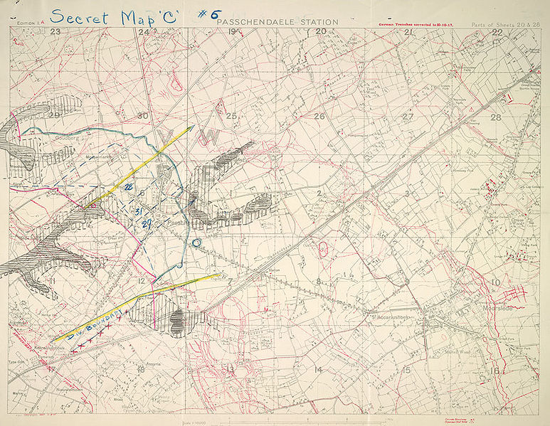
English: Secret map "C" #6 Passchendaele Station |
||||||||||||||||||||||||||
| Descrizione |
English: 1:10000 scale map. Secret map "C" #6 Au verso: 16, 6th Cdn. Inf. Bde. MAP "C" 30/10/17, readjustment of boundaries and amended objectives. . |
||||||||||||||||||||||||||
| Data | |||||||||||||||||||||||||||
| Fonte |
|
||||||||||||||||||||||||||
| Creatore |
War Office. General Staff. Geographical Section, Field Service Battalion, Royal Engineers |
||||||||||||||||||||||||||
| Licenza (Riusare questo file) |
|
||||||||||||||||||||||||||
| Geotemporal data | |||||||||||||||||||||||||||
| Data rappresentata | |||||||||||||||||||||||||||
| Map location | Passendale | ||||||||||||||||||||||||||
| Map type | trench map | ||||||||||||||||||||||||||
| Scala | 1:10000 | ||||||||||||||||||||||||||
| Heading |
 |
||||||||||||||||||||||||||
| Bounding box |
|
||||||||||||||||||||||||||
| Georeferencing | |||||||||||||||||||||||||||
| Bibliographic data | |||||||||||||||||||||||||||
| Map sheet | 20 & 28 | ||||||||||||||||||||||||||
| Lingua | inglese | ||||||||||||||||||||||||||
| Casa editrice |
Royal Engineers |
||||||||||||||||||||||||||
| Archival data | |||||||||||||||||||||||||||
| Collezione |
|
||||||||||||||||||||||||||
| Dimensioni | altezza: 39,5 cm; larghezza: 54,5 cm | ||||||||||||||||||||||||||


_Brigade_Planning_Map.jpg?uselang=it)
_Brigade_Planning_Map.jpg)
_Brigade_Planning_Map.jpg&action=edit)
Cronologia del file
Fare clic su un gruppo data/ora per vedere il file come si presentava nel momento indicato.
| Data/Ora | Miniatura | Dimensioni | Utente | Commento | |
|---|---|---|---|---|---|
| attuale | 23:32, 25 mag 2009 | | 979 × 759 (386 KB) | Cropbot | upload cropped version, operated by User:Finavon. Summary: border cropped |
| 18:51, 18 gen 2009 |  | 1 000 × 775 (300 KB) | Labattblueboy | {{Information |Description={{en|1=1: 10000 scale map. Secret map "C" #6 Au verso: 16, 6th Cdn. Inf. Bde. MAP "C" 30/10/17, readjustment of boundaries and amended objectives. }} |Source={{LAC|80103-51 CA|3706069}} |Author=Field Survey Company, Royal Engine |
Pagine che usano questo file
La seguente pagina usa questo file:
Utilizzo globale del file
Anche i seguenti wiki usano questo file:
- Usato nelle seguenti pagine di en.wikipedia.org:
_Brigade_Planning_Map.jpg)