File proveniente da Wikimedia Commons. Clicca per visitare la pagina originale

File:Recent Sea Level Rise.png

Da Wikipedia, l'enciclopedia libera.
Vai alla navigazione Vai alla ricerca

Recent_Sea_Level_Rise.png(537 × 373 pixel, dimensione del file: 47 KB, tipo MIME: image/png)

Logo di Commons
Logo di Commons
Questo file e la sua pagina di descrizione (discussione · modifica) si trovano su Wikimedia Commons (?)

Dettagli

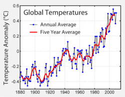
Temperature changes during a similar period and possibly responsible for causing the observed sea level rise.
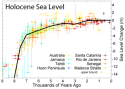
Sea level variations over the last nine thousand years

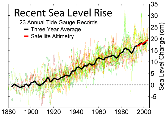
This figure shows the change in annually averaged sea level at 23 geologically stable tide gauge sites with long-term records as selected by Douglas (1997). The thick dark line is a three-year moving average of the instrumental records. These data indicate a sea level rise of ~27.5 cm from 1800-2000. Because of the limited geographic coverage of these records, it is not obvious whether the apparent decadal fluctuations represent true variations in global sea level or merely variations across regions that are not resolved.

For comparison, the recent annually averaged satellite altimetry data [1] from TOPEX/Poseidon are shown in red. These data indicate a somewhat higher rate of increase than tide gauge data, however the source of this discrepancy is not obvious. It may represent systematic error in the satellite record and/or incomplete geographic sampling in the tide gauge record. The month to month scatter on the satellite measurements is roughly the thickness of the plotted red curve.

Data

Original data for this figure are from the Permanent Service for Mean Sea Level [2] copia archiviata at the Wayback Machine (PSMSL). Douglas (1997), defined the following criteria for selecting records from the PSMSL which were long, reliable, and avoided large vertical geologic changes:

  1. Each record should be at least 60 years in length
  2. Not be located at collisional plate boundaries
  3. At least 80% complete
  4. Show reasonable agreement at low frequencies with nearby gauges sampling the same water mass
  5. Not be located in regions subject to large post-glacial rebound

He subsequently identified 24 PSMSL records meeting all five of these criteria:

  1. Auckland, 1903-2000
  2. Balboa, 1908-1996
  3. Brest, 1807-2000
  4. Buenos Aires, Argentina, 1905-1987
  5. Cascais, 1882-1993
  6. Cristobal, 1909-1980
  7. Dunedin, 1900-1998
  8. Fernandina, 1897-2003
  9. Genova, 1884-1997
  10. Honolulu, 1905-2003
  11. Key West, 1913-2003
  12. Lagos, 1908-1999
  13. La Jolla, 1924-2003
  14. Lyttelton, 1924-2000
  15. Marseille, 1885-2000
  16. Newlyn, Cornwall, 1915-2003
  17. Pensacola, 1923-2003
  18. Quequen, 1918-1982
  19. San Diego, 1906-2003
  20. San Francisco, 1854-2003
  21. Santa Cruz de Tenerife, 1927-1990
  22. Santa Monica, 1933-2003
  23. Trieste, 1905-2001
  24. Wellington, 1901-1988

After slight corrections following Douglas (1997) for any remaining post-glacial rebound at these sites (typically ~3 cm/century), the tide gauge data from these sites were plotted in no particular order as the thin lines in the above figure. One site, Wellington, was omitted because the author of this figure was unable to locate the corresponding record from the PSMSL.

This figure was prepared from publicly available data by Robert A. Rohde and is incorporated into the Global Warming Art project.

Image from Global Warming Art
This image is an original work created for Global Warming Art. Please refer to the image description page for more information.
GNU head È permesso copiare, distribuire e/o modificare questo documento in base ai termini della GNU Free Documentation License, Versione 1.2 o successive pubblicata dalla Free Software Foundation; senza alcuna sezione non modificabile, senza testo di copertina e senza testo di quarta di copertina. Una copia della licenza è inclusa nella sezione intitolata Testo della GNU Free Documentation License.
w:it:Creative Commons
attribuzione condividi allo stesso modo
Questo file è disponibile in base alla licenza Creative Commons Attribuzione-Condividi allo stesso modo 3.0 Unported
Tu sei libero:
  • di condividere – di copiare, distribuire e trasmettere quest'opera
  • di modificare – di adattare l'opera
Alle seguenti condizioni:
  • attribuzione – Devi fornire i crediti appropriati, un collegamento alla licenza e indicare se sono state apportate modifiche. Puoi farlo in qualsiasi modo ragionevole, ma non in alcun modo che suggerisca che il licenziante approvi te o il tuo uso.
  • condividi allo stesso modo – Se remixi, trasformi o sviluppi il materiale, devi distribuire i tuoi contributi in base alla stessa licenza o compatibile all'originale.
Questo tag di copyright è stato aggiunto nell'ambito dell'aggiornamento della licenza dei progetti Wikimedia.


Reference

Bruce C. Douglas (1997). "Global Sea Rise: A Redetermination". Surveys in Geophysics 18: 279–292. DOI:10.1023/A:1006544227856.


Questa immagine (categorizzazione automatica: geology) o tutte le immagini in questa categoria o galleria dovrebbero essere ricreate usando grafica vettoriale come file SVG. Questo offre diversi vantaggi: vedi Commons:Media for cleanup per maggiori informazioni. Se è disponibile una versione in formato SVG di questa immagine, per favore caricala. Dopo aver caricato un file SVG, sostituisci questo avviso con il template {{Vector version available|nome_immagine.svg}}.

Didascalie

Aggiungi una brevissima spiegazione di ciò che questo file rappresenta

Elementi ritratti in questo file

raffigura

image/png

Cronologia del file

Fare clic su un gruppo data/ora per vedere il file come si presentava nel momento indicato.

Data/OraMiniaturaDimensioniUtenteCommento
attuale16:49, 26 dic 2005Miniatura della versione delle 16:49, 26 dic 2005537 × 373 (47 KB)AngrenseRecent changes in seal level. Source:English version of Wikipedia.

Nessuna pagina utilizza questo file.

Utilizzo globale del file

Anche i seguenti wiki usano questo file:

Visualizza l'utilizzo globale di questo file.
Metadati