File:Paricutin 30 612.jpg
Vai alla navigazione
Vai alla ricerca

Dimensioni di questa anteprima: 400 × 600 pixel. Altre risoluzioni: 160 × 240 pixel | 320 × 480 pixel | 667 × 1 000 pixel.
File originale (667 × 1 000 pixel, dimensione del file: 53 KB, tipo MIME: image/jpeg)
| Questo file e la sua pagina di descrizione (discussione · modifica) si trovano su Wikimedia Commons (?) |
Dettagli
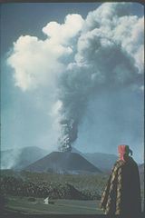
| Descrizione | This slide shows the cinder cone soon after its birth in 1943 in a Mexican cornfield. During its brief nine-year lifespan (1943-1952), it built a 410-meter-high cone with extensive lava fields around the base of the cone. Most of the 2 km3 of eruptive products (ash, cinders, and lava) were produced in the first few years. Cinder cones such as this one are commonly formed by one eruption. Each subsequent eruption in the same area forms its own cinder cone. |
| Data | |
| Fonte | http://www.ngdc.noaa.gov/seg/hazard/slideset/30/30_612_slide.shtml |
| Autore | Photo credit: K. Segerstrom, U.S. Geological Survey |
| Licenza (Riusare questo file) |
PD-USGov-NOAA |
Questa immagine o file multimediale è di pubblico dominio poiché contiene materiale proveniente della National Oceanic and Atmospheric Administration, realizzato da personale dipendente durante l'assolvimento dei propri compiti ufficiali.
|
Cronologia del file
Fare clic su un gruppo data/ora per vedere il file come si presentava nel momento indicato.
| Data/Ora | Miniatura | Dimensioni | Utente | Commento | |
|---|---|---|---|---|---|
| attuale | 22:31, 17 ott 2006 | | 667 × 1 000 (53 KB) | Alhen | {{Information |Description= Paricutin, Mexico;19.48 N 102.25 W;3,170 m elevation This slide shows the cinder cone soon after its birth in 1943 in a Mexican cornfield. During its brief nine-year lifespan (1943-1952), it built a 410-mete |
| 22:18, 17 ott 2006 |  | 667 × 1 000 (49 KB) | Alhen | {{Information |Description= w:Paricutin, Mexico;19.48 N 102.25 W;3,170 m elevation This slide shows the cinder cone soon after its birth in 1943 in a Mexican cornfield. During its brief nine-year lifespan (1943-1952), it built a 410-meter-high co |
Pagine che usano questo file
La seguente pagina usa questo file:
Utilizzo globale del file
Anche i seguenti wiki usano questo file:
- Usato nelle seguenti pagine di ar.wikipedia.org:
- Usato nelle seguenti pagine di ast.wikipedia.org:
- Usato nelle seguenti pagine di ca.wikipedia.org:
- Usato nelle seguenti pagine di de.wikipedia.org:
- Usato nelle seguenti pagine di dv.wikipedia.org:
- Usato nelle seguenti pagine di el.wikipedia.org:
- Usato nelle seguenti pagine di en.wikipedia.org:
- Usato nelle seguenti pagine di en.wikibooks.org:
- Usato nelle seguenti pagine di es.wikipedia.org:
- Usato nelle seguenti pagine di fa.wikipedia.org:
- Usato nelle seguenti pagine di fr.wikipedia.org:
- Usato nelle seguenti pagine di hu.wikipedia.org:
- Usato nelle seguenti pagine di ja.wikipedia.org:
- Usato nelle seguenti pagine di ko.wikipedia.org:
- Usato nelle seguenti pagine di lt.wikipedia.org:
- Usato nelle seguenti pagine di mk.wikipedia.org:
- Usato nelle seguenti pagine di mr.wikipedia.org:
- Usato nelle seguenti pagine di nah.wikipedia.org:
- Usato nelle seguenti pagine di nn.wikipedia.org:
- Usato nelle seguenti pagine di no.wikipedia.org:
- Usato nelle seguenti pagine di oc.wikipedia.org:
- Usato nelle seguenti pagine di pl.wikipedia.org:
- Usato nelle seguenti pagine di ro.wikipedia.org:
- Usato nelle seguenti pagine di ru.wikipedia.org:
- Usato nelle seguenti pagine di sh.wikipedia.org:
- Usato nelle seguenti pagine di tr.wikipedia.org:
- Usato nelle seguenti pagine di uk.wikipedia.org: