File:Nansen Fram Map.png
Vai alla navigazione
Vai alla ricerca
Non sono disponibili versioni a risoluzione più elevata.
Nansen_Fram_Map.png (800 × 479 pixel, dimensione del file: 195 KB, tipo MIME: image/png)
| Questo file e la sua pagina di descrizione (discussione · modifica) si trovano su Wikimedia Commons (?) |
Dettagli
| Descrizione |
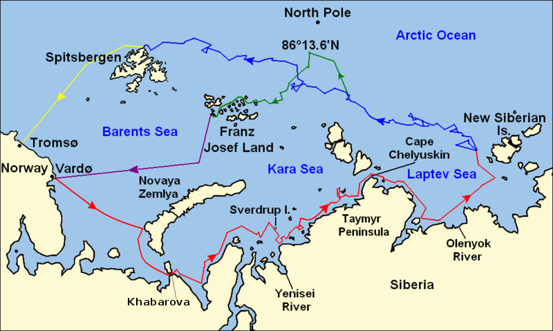
Map of the Arctic Ocean showing the routes taken during the 1893–96 Nansen's Fram expedition: Fram's route eastward from Vardø to the Siberian coast, turning north at the New Siberian Islands to enter the pack ice. July – September 1893 Fram's drift in the ice from the New Siberian Islands, north and west to Spitsbergen, September 1893 – August 1896 Nansen and Johansen's march to Farthest North, 86°20'N, and their subsequent retreat to Cape Flora in Franz Josef Land. February 1895 – June 1896 Nansen and Johansen's return to Vardø from Cape Flora, August 1896 Fram's voyage from Spitsbergen to Tromsø, August 1896 |
| Data | |
| Fonte | Base map of European and Asian mainland is from File:Map of Russian Subjects old.png by User:fremantleboy, map of Spitsbergen (Svalbard) is based on File:Bjornoya map.png by User:NormanEinstein. Voyage traces based on this map from The Northern Lights Route. First published in Nansen, Fridtjof: Farthest North, Constable & Co, London 1897 |
| Autore | User:fremantleboy, User:NormanEinstein, Ruhrfisch |
| Licenza (Riusare questo file) |
GFDL, CC-BY-SA |
| Altre versioni |
|


|
File:Nansen Fram Map.svg è una versione vettoriale di questo file. Dovrebbe essere usata quella versione al posto di questo file PNG, quando sia migliore.
File:Nansen Fram Map.png → File:Nansen Fram Map.svg
Per maggiori informazioni, vedi Help:SVG. |
 |
Licenza
Io, detentore del copyright su quest'opera, dichiaro di pubblicarla con le seguenti licenze:

|
È permesso copiare, distribuire e/o modificare questo documento in base ai termini della GNU Free Documentation License, Versione 1.2 o successive pubblicata dalla Free Software Foundation; senza alcuna sezione non modificabile, senza testo di copertina e senza testo di quarta di copertina. Una copia della licenza è inclusa nella sezione intitolata Testo della GNU Free Documentation License. |
Questo file è licenziato in base ai termini delle licenze Creative Commons Attribuzione-Condividi allo stesso modo 4.0 Internazionale, 3.0 Unported, 2.5 Generico, 2.0 Generico e 1.0 Generico
- Tu sei libero:
- di condividere – di copiare, distribuire e trasmettere quest'opera
- di modificare – di adattare l'opera
- Alle seguenti condizioni:
- attribuzione – Devi fornire i crediti appropriati, un collegamento alla licenza e indicare se sono state apportate modifiche. Puoi farlo in qualsiasi modo ragionevole, ma non in alcun modo che suggerisca che il licenziante approvi te o il tuo uso.
- condividi allo stesso modo – Se remixi, trasformi o sviluppi il materiale, devi distribuire i tuoi contributi in base alla stessa licenza o compatibile all'originale.
Puoi scegliere la licenza che preferisci.
Cronologia del file
Fare clic su un gruppo data/ora per vedere il file come si presentava nel momento indicato.
| Data/Ora | Miniatura | Dimensioni | Utente | Commento | |
|---|---|---|---|---|---|
| attuale | 14:16, 8 mag 2011 | | 800 × 479 (195 KB) | Chris55 | Added [http://website.lineone.net/~polar.publishing/khabarova.htm Khabarova] where they picked up the dogs. |
| 17:50, 21 ott 2009 |  | 1 003 × 601 (78 KB) | Ruhrfisch | Make arrowheads less triangular (indentations at rear) | |
| 17:23, 21 ott 2009 |  | 1 003 × 601 (78 KB) | Ruhrfisch | Add arrowheads per FAC | |
| 20:50, 20 ott 2009 |  | 1 003 × 601 (78 KB) | Ruhrfisch | Make magenta line purple | |
| 15:36, 11 ott 2009 |  | 1 003 × 601 (78 KB) | Ruhrfisch | Yellow line for orange, some labels smaller, Farthest North replaced with actual figure, all other info the same | |
| 05:08, 11 ott 2009 |  | 1 003 × 601 (80 KB) | Ruhrfisch | Darker green for that line, all other information is the same | |
| 04:46, 11 ott 2009 |  | 1 003 × 601 (80 KB) | Ruhrfisch | Added last two lines for ice voyages, added last labels, all other information the same. | |
| 21:30, 9 ott 2009 |  | 1 003 × 601 (73 KB) | Ruhrfisch | Add labels, two more voyage lines, all other information is the same | |
| 18:12, 9 ott 2009 |  | 1 003 × 601 (57 KB) | Ruhrfisch | == Summary == {{Information |Description = Map of the Arctic Ocean showing the path of Nansen's Fram expedition 1893 to 1896 |Source = Base map of European mainland is from [[:File:Map of Russian Subjects old.png] |
Pagine che usano questo file
Nessuna pagina utilizza questo file.
Utilizzo globale del file
Anche i seguenti wiki usano questo file:
- Usato nelle seguenti pagine di bg.wikipedia.org:
- Usato nelle seguenti pagine di en.wikipedia.org:
- Usato nelle seguenti pagine di es.wikipedia.org:
- Usato nelle seguenti pagine di fr.wikipedia.org:
- Usato nelle seguenti pagine di hr.wikipedia.org:
- Usato nelle seguenti pagine di id.wikipedia.org:
- Usato nelle seguenti pagine di ja.wikipedia.org:
- Usato nelle seguenti pagine di pt.wikipedia.org:
- Usato nelle seguenti pagine di sl.wikipedia.org: