File:Map of the route of Edward III's chevauchée of 1346.svg
Vai alla navigazione
Vai alla ricerca

Dimensioni di questa anteprima PNG per questo file SVG: 643 × 600 pixel. Altre risoluzioni: 257 × 240 pixel | 515 × 480 pixel | 823 × 768 pixel | 1 098 × 1 024 pixel | 2 195 × 2 048 pixel | 1 059 × 988 pixel.
File originale (file in formato SVG, dimensioni nominali 1 059 × 988 pixel, dimensione del file: 450 KB)
| Questo file e la sua pagina di descrizione (discussione · modifica) si trovano su Wikimedia Commons (?) |
Dettagli
| Descrizione |
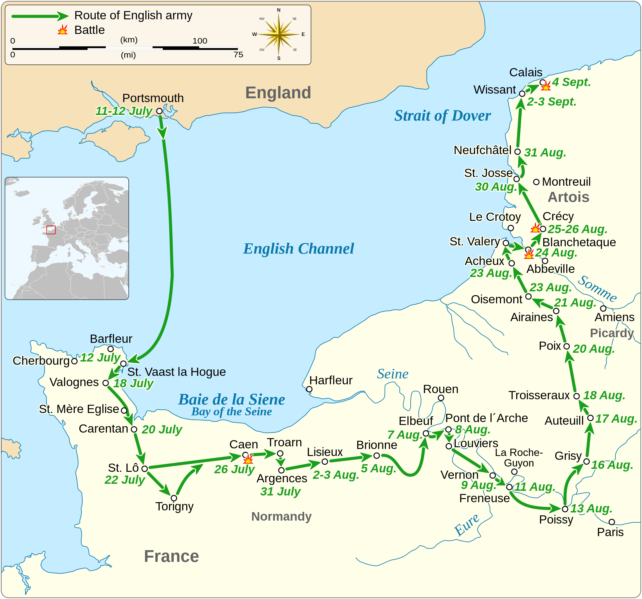
English: Map of the route of Edward III's chevauchée of 1346, part of the Hundred Years' War. This map shows the English army movements during the campaign and the most important battles.
|
||||||||||||||||||||||||||||||||||||||||||||||||
| Data | |||||||||||||||||||||||||||||||||||||||||||||||||
| Fonte |
Opera propria Derived from; Information from:
|
||||||||||||||||||||||||||||||||||||||||||||||||
| Autore | Goran tek-en | ||||||||||||||||||||||||||||||||||||||||||||||||
| Licenza (Riusare questo file) |
Questo file è disponibile in base alla licenza Creative Commons Attribuzione-Condividi allo stesso modo 4.0 Internazionale Attribuzione: Goran tek-en
|
||||||||||||||||||||||||||||||||||||||||||||||||
| SVG sviluppo | Questa grafica vettoriale è stata creata con Inkscape. |
||||||||||||||||||||||||||||||||||||||||||||||||


| Posizione del soggetto | | Posizione di questa e altre immagini su: OpenStreetMap |
|---|


Cronologia del file
Fare clic su un gruppo data/ora per vedere il file come si presentava nel momento indicato.
| Data/Ora | Miniatura | Dimensioni | Utente | Commento | |
|---|---|---|---|---|---|
| attuale | 02:14, 3 feb 2022 | | 1 059 × 988 (450 KB) | Iso10970 | Reverted to version as of 13:17, 9 November 2021 (UTC) |
| 02:13, 3 feb 2022 |  | 1 059 × 988 (614 KB) | Iso10970 | File uploaded using svgtranslate tool (https://svgtranslate.toolforge.org/). Added translation for ja. | |
| 15:17, 9 nov 2021 |  | 1 059 × 988 (450 KB) | Goran tek-en | Changed view box, font size, added location map | |
| 15:06, 14 apr 2019 |  | 1 059 × 988 (191 KB) | Goran tek-en | Spelling | |
| 19:53, 10 mar 2019 |  | 1 059 × 988 (115 KB) | JoKalliauer | phab:T36947 bad character aligment on same sizes | |
| 16:08, 6 mar 2019 |  | 1 059 × 988 (191 KB) | Goran tek-en | {{Information |description ={{en|1=Map of the route of Edward III's chevauchée of 1346, part of the Hundred Years' War. This map shows the English army movements during the campaign and the most important battles.}} |date =20190306 |source ={{Own}}<br> Derived from; * [https://www.openstreetmap.org/#map=8/49.919/1.371 OSM] Information from: * [https://www.themaparchive.com/the-crecy-campaign-12-july-to-4-september-1346.html themaparchive.com] * {{U|Newm30}} |author... |
Pagine che usano questo file
La seguente pagina usa questo file:
Utilizzo globale del file
Anche i seguenti wiki usano questo file:
- Usato nelle seguenti pagine di cs.wikipedia.org:
- Usato nelle seguenti pagine di en.wikipedia.org:
- Usato nelle seguenti pagine di es.wikipedia.org:
- Usato nelle seguenti pagine di fa.wikipedia.org:
- Usato nelle seguenti pagine di fi.wikipedia.org:
- Usato nelle seguenti pagine di fr.wikipedia.org:
- Usato nelle seguenti pagine di hu.wikipedia.org:
- Usato nelle seguenti pagine di ja.wikipedia.org:
- Usato nelle seguenti pagine di nl.wikipedia.org:
- Usato nelle seguenti pagine di pt.wikipedia.org:
- Usato nelle seguenti pagine di ru.wikipedia.org:
- Usato nelle seguenti pagine di sh.wikipedia.org:
- Usato nelle seguenti pagine di tr.wikipedia.org:
- Usato nelle seguenti pagine di zh.wikipedia.org: