File:Map of administrative regions in Israel.png

File originale (2 145 × 4 107 pixel, dimensione del file: 1,66 MB, tipo MIME: image/png)
| Questo file e la sua pagina di descrizione (discussione · modifica) si trovano su Wikimedia Commons (?) |
Dettagli
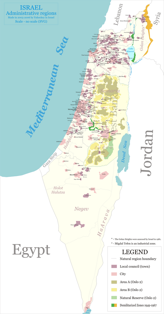
This is a map of Israeli administrative regions - districts, subdistricts, natural geographic regions (as defined by the Israeli CBS) and city/local council boundaries. This means that, for cities, it shows their municipal boundaries only, and not necessarily their urban area, which may be much smaller (this is especially the case for southern towns like Arad and Mitzpe Ramon).
This map is 'politically correct' for Israel, not the UN, and therefore shows administrative regions as the Israeli government sees them; i.e. Golan Heights and East Jerusalem belonging to Israel, as well as some municipalities in the West Bank. It does not show any localities or geographical features of Israel's neighbouring countries and territories.
This map took anywhere from 50 to 100 hours to make (lost count).
The 'attribution required' license is because I wrote 'made by Ynhockey' on the map itself and ask not to Photoshop it out or anything (or delete in SVG, you can request the SVG version from me; I won't upload it since I think 6 MB is a bit too much). No farther attribution is necessary. If putting such information on an image is against Wikimedia Commons rules, please leave me a message and I'll update the map accordingly (better to leave the message in my Wikipedia User talk:Ynhockey though). If you notice any problems on the map (it's probably not perfect), please also leave a message.
Legend (other than what's provided on the map):
- Area A is the area completely controlled by the Palestinian Authority
- Area B is the area where the Palestinian Authority has civilian control, but not military control
- The white areas are all foreign countries, the slightly darker is Israel proper, and the even darker (light yellow) is the West Bank
- A bold-italic city means a district (mahoz) capital
- Font sizes are as follows:
- 3 pt - city
- 2.5 pt - local council
- 2 pt - neither (village (kfar), moshav, kibbutz, etc.)
Other notes:
- The map was done in 2005 and 2006, and completed on March 4, 2006.
- The map was made using Corel Draw 12 and then X3. I tried Adobe Illustrator, but it didn't have the features and usability I needed. Maybe I'm not professional enough :/
- The map is 5.48"x10.5" in dimensions (according to Draw) and this version is 600 DPI. This translates to a pixel dimension of 2742x5249, and 2,388 KB in size.
- All text on the map uses the font Georgia (serif).
- As you can probably see, many small towns were added to the map (which are neither cities nor local councils), but many were not. I'm in the process of adding more, but they do not help accomplish the map's goal (showing administrative regions), so I consider the map complete without them.
Version history
- 1.5 (not yet released) - corrected borders for Jaljuliya, added village Hagor.
- 1.4 - merged all relevant towns according to the 2003 merger program, added borders for Segev-Shalom. Added local council Bnei Ayish. Added villages Kanot, Giv'at Washington, Kfar Mordechai, Kfar Aviv, Hatzav, Bnei Re'em, Revadim, Hefetz Hayim and Kidron.
- 1.3 - added Neve Yerek to region 411; added Gat Rimon, Ma'ash, Giv'at Hashlosha to 422; added Nevatim, Segev Shalom to 623. Changed colors on the demilitarized zones (all lines decided on in 1949 are now green, 1967 are orange).
- 1.2 - updated Ramat HaSharon's status to city, minor tweaks
- 1.1 - added a few small towns
Licenza

|
Il detentore del copyright di questo file, Israel Central Bureau of Statistics, permette a chiunque di utilizzarlo per qualsiasi scopo, a condizione che il detentore del copyright venga riconosciuto come tale. Sono consentiti la redistribuzione, le opere derivate, la modifica, l'uso commerciale ed ogni altro uso. |
Attribuzione:
The Central Bureau of Statistics (CBS), {{{filename}}}, ({{{access-date}}}), [{{{link}}} available online] copied and distributed as is in accordance with the CBS license.
|

|
According to the CBS license, you may not make the following use of the Information, whether by positive act or by omission:
|

|
È permesso copiare, distribuire e/o modificare questo documento in base ai termini della GNU Free Documentation License, Versione 1.2 o successive pubblicata dalla Free Software Foundation; senza alcuna sezione non modificabile, senza testo di copertina e senza testo di quarta di copertina. Una copia della licenza è inclusa nella sezione intitolata Testo della GNU Free Documentation License. |
| Questo file è disponibile in base alla licenza Creative Commons Attribuzione-Condividi allo stesso modo 3.0 Unported | ||
| ||
| Questo tag di copyright è stato aggiunto nell'ambito dell'aggiornamento della licenza dei progetti Wikimedia. |
- Tu sei libero:
- di condividere – di copiare, distribuire e trasmettere quest'opera
- di modificare – di adattare l'opera
- Alle seguenti condizioni:
- attribuzione – Devi fornire i crediti appropriati, un collegamento alla licenza e indicare se sono state apportate modifiche. Puoi farlo in qualsiasi modo ragionevole, ma non in alcun modo che suggerisca che il licenziante approvi te o il tuo uso.
Cronologia del file
Fare clic su un gruppo data/ora per vedere il file come si presentava nel momento indicato.
| Data/Ora | Miniatura | Dimensioni | Utente | Commento | |
|---|---|---|---|---|---|
| attuale | 11:40, 30 lug 2008 | | 2 145 × 4 107 (1,66 MB) | Michiel1972 | reduced 65%, still not seen |
| 11:38, 30 lug 2008 |  | 2 640 × 5 055 (2,26 MB) | Michiel1972 | reduced size, otherwise can not be used/seen | |
| 22:39, 2 ott 2006 |  | 3 300 × 6 318 (2,98 MB) | Ynhockey | Version 1.4 - see changelog. | |
| 23:12, 20 mag 2006 |  | 3 300 × 6 318 (2,96 MB) | Ynhockey | Version 1.3 (details on image page). | |
| 21:08, 4 mar 2006 |  | 3 300 × 6 318 (2,94 MB) | Ynhockey | ==Summary== This is a map of Israeli administrative regions - districts, subdistricts, natural geographic regions (as defined by the Israeli CBS) and city/local council boundaries. This map is 'politically correct' for Israel, not the UN, and therefore s | |
| 15:58, 4 mar 2006 |  | 2 742 × 5 249 (2,36 MB) | Ynhockey | This is a map of Israeli administrative regions - districts, subdistricts, natural geographic regions (as defined by the Israeli CBS) and city/local council boundaries. This map is 'politically correct' for Israel, not the UN, and therefore shows adminis |
Pagine che usano questo file
La seguente pagina usa questo file: