File:Map of European countries by maximum blood alcohol level.svg

File originale (file in formato SVG, dimensioni nominali 680 × 520 pixel, dimensione del file: 646 KB)
| Questo file e la sua pagina di descrizione (discussione · modifica) si trovano su Wikimedia Commons (?) |
Dettagli
| Descrizione |
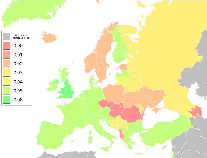
Map of Europe showing countries' blood alcohol limits (the "drink-drive" limit) as defined in g/dl (grams per decilitre). A decilitre is 100 millilitres, or one tenth of a litre. 10 mg/100ml is 0.1g/l is 0.01 g/dl. Figures for a fully qualified driver – some countries enforce lower limits for newly qualified and/or professional drivers. Note: Status of Kosovo and North Cyprus unclear in source; no figures for Denmark and Luxembourg included in source; Israel forms part of EURO, the Regional Office for Europe of the WHO. Information taken from European status report on road safety (PDF). Regional Office for Europe (World Health Organization) (2008). Retrieved on 12 February 2012. For the benefit of colorblind users, please use File:Map of European countries by maximum blood alcohol level (colorblind).svg instead. |
| Data | (UTC) |
| Fonte |
Questo file deriva da: Blank map of Europe (with disputed regions).svg: |
| Autore |
|
| Altre versioni |
.svg) |
| SVG sviluppo | Il codice sorgente di questo file SVG non è valido a causa di 2 errori. Questa mappa in grafica vettoriale non valida secondo il W3C è stata creata con Inkscape. |
.svg)
Licenza
- Tu sei libero:
- di condividere – di copiare, distribuire e trasmettere quest'opera
- di modificare – di adattare l'opera
- Alle seguenti condizioni:
- attribuzione – Devi fornire i crediti appropriati, un collegamento alla licenza e indicare se sono state apportate modifiche. Puoi farlo in qualsiasi modo ragionevole, ma non in alcun modo che suggerisca che il licenziante approvi te o il tuo uso.
- condividi allo stesso modo – Se remixi, trasformi o sviluppi il materiale, devi distribuire i tuoi contributi in base alla stessa licenza o compatibile all'originale.
Registro originale del caricamento
This image is a derivative work of the following images:
- File:Blank_map_of_Europe.svg licensed with Cc-by-sa-2.5
- 2011-09-19T22:57:58Z Alphathon 680x520 (603759 Bytes) Added North/Northern Cyprus
- 2011-08-23T10:26:48Z Heb 680x520 (604212 Bytes) Added [[:en:Bornholm]] (taken from [[:File:Denmark blank map.svg]])
- 2011-04-12T00:40:40Z Alphathon 680x520 (602549 Bytes) Upgraded Sicily based on "File:Freeworldmaps-sicily.jpg". Upgraded Malta based on "File:Map of Malta 2.png". Simplified Croatian borders.
- 2011-04-10T21:43:04Z Alphathon 680x520 (607359 Bytes) Upgraded Croatia, Bosnia & Herzegovina, Slovenia and surrounding countries based on data from "File:Kroatien - Politische Gliederung (Karte).png"
- 2011-04-10T20:05:09Z Alphathon 680x520 (568373 Bytes) Improved Serbia, Montenegro and surrounding countries using data from "File:Serbia Map.png". Fixed Serbia-Montenegro border. Added Kosovo (using dashed border, since it is not a universally recognised nation, and left the lan
- 2011-04-10T15:55:02Z Alphathon 680x520 (524980 Bytes) Tweaked Ukraine and surrounding countries based on data from "File:Up-map.png"
- 2011-04-10T04:02:09Z Alphathon 680x520 (511168 Bytes) Improved Greece, Albania, F.Y.R. Macedonia and Bulgaria based on "File:Greece topo.jpg"
- 2011-04-10T02:48:52Z Alphathon 680x520 (505569 Bytes) Tweaked Germany and surrounding countries based on info from "File:Germany_general_map.png"
- 2011-04-10T01:54:05Z Alphathon 680x520 (493733 Bytes) Converted all lakes back to separate layer. Added Finish lakes and tweaked Finland shape based on "File:Finland 1996 CIA map.jpg". Added Swiss lakes based on "File:Suisse cantons.svg". Tweaked Scotland and added Lochs.
- 2011-04-10T00:07:54Z Alphathon 680x520 (450120 Bytes) Improved England outline and added Isle of Wight based on "File:England Regions - Blank.svg". Improved Denmark based on "File:2 digit postcode danmark.png". Improved Sweden based on "File:Map of Sweden, CIA, 1996.jpg"
- 2011-04-08T15:53:07Z Alphathon 680x520 (438878 Bytes) Upgraded/fixed various parts of the map. Details: *Some minor fixes to Ireland and added some of the larger lakes based on [[:File:Ireland_trad_counties_named.svg]] *Pretty major fixes to Scotland (mainly the west coast and i
- 2008-09-17T09:50:25Z F7 680x520 (531491 Bytes)
- 2008-09-17T09:42:57Z F7 680x520 (2353 Bytes)
- 2008-05-26T19:04:07Z Collard 680x520 (531491 Bytes) uploading on behalf of [[User:Checkit]], direct complaints to him plox: 'Moved countries out of the "outlines" group, removed "outlines" style class, remove separate style information for Russia'
- 2008-04-30T01:38:52Z TimothyBourke 680x520 (531767 Bytes) Changed the country code of Serbia to RS per [http://en.wikipedia.org/wiki/Serbian_country_codes] and the file [http://www.iso.org/iso/iso3166_en_code_lists.txt].
- 2008-02-08T22:44:37Z CarolSpears 680x520 (531767 Bytes) validated
- 2007-07-10T11:47:59Z MrWeeble 680x520 (533112 Bytes) Updated to include British Crown Dependencies as seperate entities and regroup them as "British Islands", with some simplifications to the XML and CSS
- 2007-05-14T17:17:34Z Zirland 680x520 (540659 Bytes) serbia and montenegro
- 2007-03-30T20:40:49Z W!B: 680x520 (538830 Bytes) minor corr: update nl:Ijsselmeer, del fi:lakes (all small), add ru:lake Oneka (all ref maps.google), glued northern irland back to ie ;)
- 2007-02-05T18:44:32Z Maix 680x520 (538295 Bytes) cropped
- 2007-02-04T15:07:29Z Maix 680x520 (538310 Bytes) {{Information |Description=A blank Map of Europe in SVG format. Every country has an id which is its ISO-3116-1-ALPHA2 code in lower case for easy coloring. |Source=Image based on [[Image:Europe_countries.svg|]] by [[User:Ti
Uploaded with derivativeFX
Cronologia del file
Fare clic su un gruppo data/ora per vedere il file come si presentava nel momento indicato.
| Data/Ora | Miniatura | Dimensioni | Utente | Commento | |
|---|---|---|---|---|---|
| attuale | 22:55, 14 nov 2023 | | 680 × 520 (646 KB) | Ich | Reverted to version as of 07:13, 31 July 2021 (UTC) |
| 16:23, 4 nov 2021 |  | 680 × 520 (641 KB) | Ich | New color scheme for the color-blind | |
| 09:13, 31 lug 2021 |  | 680 × 520 (646 KB) | Gajmar | Update | |
| 18:48, 5 ago 2020 |  | 680 × 520 (652 KB) | Oman160 | Updated Serbia and fixed Kaliningrad to match with mainland Russia | |
| 12:12, 30 gen 2019 |  | 680 × 520 (647 KB) | Калий | Reverted to version as of 21:15, 3 May 2015 (UTC) | |
| 12:11, 30 gen 2019 |  | 9 938 × 7 945 (622 KB) | Калий | Update Russia (0.0356%) | |
| 23:15, 3 mag 2015 |  | 680 × 520 (647 KB) | Thincat | Update Scotland | |
| 11:25, 17 feb 2014 |  | 680 × 520 (602 KB) | Frenzie23 | Belarus - 0.00 Bosnia and Herzegovina - 0.03 (actual 0.031) | |
| 15:01, 9 feb 2013 |  | 680 × 520 (602 KB) | Tbp386 | Aligned map colours with article | |
| 19:46, 12 feb 2012 |  | 680 × 520 (598 KB) | Grandiose | enhance colours |
Pagine che usano questo file
Nessuna pagina utilizza questo file.