File:Lesser Prairie Chicken Tympanuchus pallidicinctus distribution map.png
File originale (800 × 763 pixel, dimensione del file: 124 KB, tipo MIME: image/png)
| Questo file e la sua pagina di descrizione (discussione · modifica) si trovano su Wikimedia Commons (?) |
Dettagli
| Descrizione |
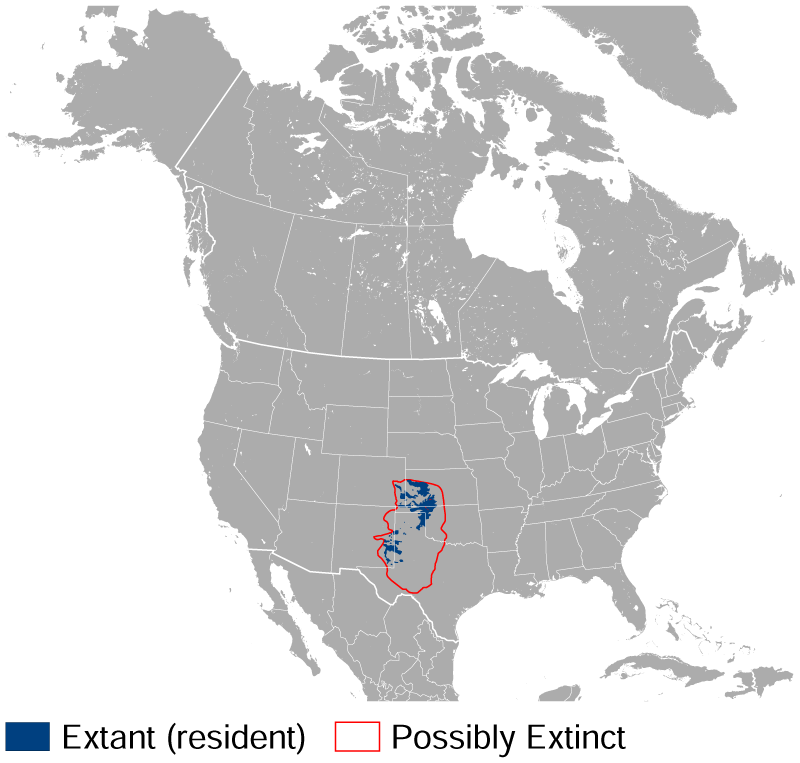
English: Geographical distribution of the Lesser Prairie Chicken Tympanuchus pallidicinctus. The map was created using the Generic Mapping Tools, GMT, version 5.1.2. |
| Data | |
| Fonte |
Opera propria usando: the IUCN Red List spatial data to draw the borders of the Tympanuchus pallidicinctus range: Questa mappa in immagine è stata creata con GMT. |
| Autore | Darekk2 using the IUCN Red List spatial data |
Licenza
Attribution: The author of the work and the IUCN Red List spatial data.
You must provide the appropriate credit for the IUCN Red List spatial data:
BirdLife International and NatureServe (2014) Bird Species Distribution Maps of the World. 2012. Tympanuchus pallidicinctus. In: IUCN 2015. The IUCN Red List of Threatened Species. Version 2015.2. http://www.iucnredlist.org. Downloaded on 09 July 2015.
and the IUCN Red List spatial data
- Tu sei libero:
- di condividere – di copiare, distribuire e trasmettere quest'opera
- di modificare – di adattare l'opera
- Alle seguenti condizioni:
- attribuzione – Devi fornire i crediti appropriati, un collegamento alla licenza e indicare se sono state apportate modifiche. Puoi farlo in qualsiasi modo ragionevole, ma non in alcun modo che suggerisca che il licenziante approvi te o il tuo uso.
- condividi allo stesso modo – Se remixi, trasformi o sviluppi il materiale, devi distribuire i tuoi contributi in base alla stessa licenza o compatibile all'originale.
Cronologia del file
Fare clic su un gruppo data/ora per vedere il file come si presentava nel momento indicato.
| Data/Ora | Miniatura | Dimensioni | Utente | Commento | |
|---|---|---|---|---|---|
| attuale | 17:00, 9 lug 2015 | | 800 × 763 (124 KB) | Darekk2 | User created page with UploadWizard |
Pagine che usano questo file
La seguente pagina usa questo file:
Utilizzo globale del file
Anche i seguenti wiki usano questo file:
- Usato nelle seguenti pagine di da.wikipedia.org:
- Usato nelle seguenti pagine di nv.wikipedia.org:
- Usato nelle seguenti pagine di uk.wikipedia.org: