File:Japanese Empire - 1942.svg
Vai alla navigazione
Vai alla ricerca

Dimensioni di questa anteprima PNG per questo file SVG: 788 × 600 pixel. Altre risoluzioni: 316 × 240 pixel | 631 × 480 pixel | 1 009 × 768 pixel | 1 280 × 974 pixel | 2 560 × 1 948 pixel | 1 100 × 837 pixel.
File originale (file in formato SVG, dimensioni nominali 1 100 × 837 pixel, dimensione del file: 875 KB)
| Questo file e la sua pagina di descrizione (discussione · modifica) si trovano su Wikimedia Commons (?) |
Dettagli
| Descrizione |
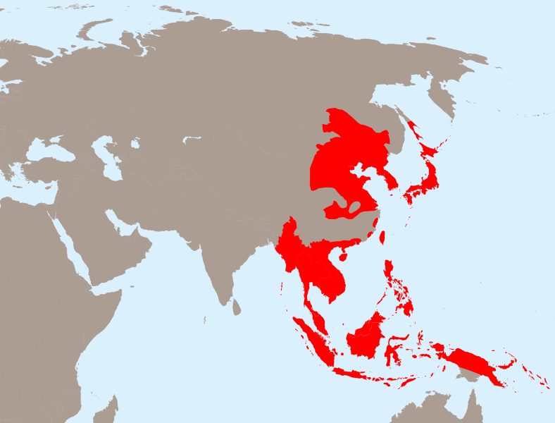
English: The Empire of Japan at its height in 1942.
Français : Japon 1942
Deutsch: Japanisches Reich 1942 |
| Data | |
| Fonte | Opera propria basata su: Empire of Japan (1868-1945).png di Mackay 86, Asie.svg di historicair e Japanese Empire2.png di Mackay 86 |
| Autore |
Vettoriale: |
| SVG sviluppo | Questa mappa in grafica vettoriale è stata creata con Inkscape. |
.png)
Licenza
Questo file è disponibile in base alla licenza Creative Commons Attribuzione-Condividi allo stesso modo 3.0 Unported
- Tu sei libero:
- di condividere – di copiare, distribuire e trasmettere quest'opera
- di modificare – di adattare l'opera
- Alle seguenti condizioni:
- attribuzione – Devi fornire i crediti appropriati, un collegamento alla licenza e indicare se sono state apportate modifiche. Puoi farlo in qualsiasi modo ragionevole, ma non in alcun modo che suggerisca che il licenziante approvi te o il tuo uso.
- condividi allo stesso modo – Se remixi, trasformi o sviluppi il materiale, devi distribuire i tuoi contributi in base alla stessa licenza o compatibile all'originale.
Registro originale del caricamento
This image is a derivative work of the following images:
- Empire of Japan (1868-1945).png licensed with PD-user-w
- 2010-04-13T05:49:21Z File Upload Bot (Magnus Manske) 1000x600 (183888 Bytes) {{BotMoveToCommons|en.wikipedia|year={{subst:CURRENTYEAR}}|month={{subst:CURRENTMONTHNAME}}|day={{subst:CURRENTDAY}}}} {{Information |Description={{en|The Empire of Japan at its height in 1942.}} |Source=Transferred from [ht
- Asie.svg licensed with PD-self
- 2006-11-23T21:09:53Z Historicair 1100x837 (902355 Bytes)
- 2006-11-23T20:25:19Z Historicair 1100x837 (902408 Bytes)
- 2006-11-22T22:59:34Z Historicair 1100x837 (898316 Bytes)
- 2006-11-21T18:36:45Z Historicair 1100x837 (897827 Bytes)
- 2006-11-20T20:31:48Z Historicair 1100x837 (816138 Bytes) {{Information |Description={{fr|1=Carte vierge de l'Asie }}{{en|1=Asia Blank map}} |Source=http://en.wikipedia.org/wiki/Image:BlankMap-World5.svg |Date=20/11/2006 |Author=~~~~ |Permission={{PD-self}} |other_versions= }} {{Atelier g
- Japanese Empire2.png licensed with Cc-by-sa-3.0-migrated, GFDL
- 2007-07-05T11:47:48Z Mahahahaneapneap 707x591 (32385 Bytes) pngcrushed
- 2007-05-27T01:31:13Z Gryffindor 707x591 (49084 Bytes) {{svg}} {{GFDL}} Modified version of [[:Image:Japanese_Empire.png]]. Fixed Ryukyu Islands, Sichuan, grammar in table. [[Category:Maps of the history of Japan]] [[Category:Maps of the history of Korea]] [[Category:Maps of th
- 2007-02-27T15:13:21Z Cristan 508x591 (37210 Bytes) Optimized using PNGOUT
- 2005-12-22T11:24:51Z Markalexander100 508x591 (47890 Bytes) {{GFDL}} Modified version of [[:Image:Japanese_Empire.png]]. Fixed Ryukyu Islands, Sichuan, grammar in table.
Uploaded with derivativeFX
Cronologia del file
Fare clic su un gruppo data/ora per vedere il file come si presentava nel momento indicato.
| Data/Ora | Miniatura | Dimensioni | Utente | Commento | |
|---|---|---|---|---|---|
| attuale | 22:13, 31 mar 2020 | | 1 100 × 837 (875 KB) | Esmu Igors | Northern part of the Sakhalin island was transferred from Japan to Soviet Russia in 1925, and the borders remained untouched until the end of WWII. Hence this territory should be omitted from the map. |
| 22:13, 31 mar 2020 |  | 1 100 × 837 (904 KB) | Esmu Igors | Reverted to version as of 01:24, 25 April 2010 (UTC) (unsuccessful edit in the Inkscape) | |
| 22:11, 31 mar 2020 |  | 1 100 × 837 (882 KB) | Esmu Igors | Northern part of the Sakhalin island was transferred from Japan to Soviet Russia in 1925, and the borders remained untouched until the end of WWII. Hence this territory should be omitted from the map. | |
| 03:24, 25 apr 2010 |  | 1 100 × 837 (904 KB) | Ras67 | borders removed | |
| 23:44, 23 apr 2010 |  | 1 100 × 837 (911 KB) | TastyCakes | Tweaked some borders and coloured some islands that I missed | |
| 23:29, 23 apr 2010 |  | 1 100 × 837 (911 KB) | TastyCakes | {{Information |Description={{en|The Empire of Japan at its height in 1942.}} {{fr}}Carte vierge de l'Asie {{en}}Asia Blank map |Source=*File:Empire_of_Japan_(1868-1945).png *File:Asie.svg *File:Japanese_Empire2.png |Date=2010-04-23 21:26 |
.png)
Pagine che usano questo file
La seguente pagina usa questo file:
Utilizzo globale del file
Anche i seguenti wiki usano questo file:
- Usato nelle seguenti pagine di ar.wikipedia.org:
- Usato nelle seguenti pagine di bcl.wikipedia.org:
- Usato nelle seguenti pagine di be.wikipedia.org:
- Usato nelle seguenti pagine di cs.wikipedia.org:
- Usato nelle seguenti pagine di de.wikipedia.org:
- Usato nelle seguenti pagine di en.wikipedia.org:
- Usato nelle seguenti pagine di fo.wikipedia.org:
- Usato nelle seguenti pagine di fr.wikipedia.org:
- Usato nelle seguenti pagine di id.wikipedia.org:
- Usato nelle seguenti pagine di ja.wikipedia.org:
- Usato nelle seguenti pagine di km.wikipedia.org:
- Usato nelle seguenti pagine di ms.wikipedia.org:
- Usato nelle seguenti pagine di no.wikipedia.org:
- Usato nelle seguenti pagine di ru.wikipedia.org:
- Usato nelle seguenti pagine di simple.wikipedia.org:
- Usato nelle seguenti pagine di sv.wikipedia.org:
- Usato nelle seguenti pagine di th.wikipedia.org:
- Usato nelle seguenti pagine di tl.wikipedia.org:
- Usato nelle seguenti pagine di uk.wikipedia.org:
- Usato nelle seguenti pagine di zh-min-nan.wikipedia.org:
- Usato nelle seguenti pagine di zh-yue.wikipedia.org:
- Usato nelle seguenti pagine di zh.wikipedia.org:
Visualizza l'utilizzo globale di questo file.