File:ISS-38 Southern Patagonian Ice Field.jpg
Vai alla navigazione
Vai alla ricerca

Dimensioni di questa anteprima: 800 × 532 pixel. Altre risoluzioni: 320 × 213 pixel | 640 × 426 pixel | 1 024 × 681 pixel | 1 280 × 852 pixel | 2 560 × 1 703 pixel | 4 256 × 2 832 pixel.
File originale (4 256 × 2 832 pixel, dimensione del file: 1,2 MB, tipo MIME: image/jpeg)
| Questo file e la sua pagina di descrizione (discussione · modifica) si trovano su Wikimedia Commons (?) |
Dettagli
| Descrizione |
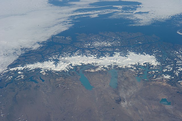
English: This grand panorama of the Southern Patagonia Icefield (center) was imaged by an Expedition 38 crew member on the International Space Station on one of the rare clear days in the southern Andes Mountains.
|
| Data | |
| Fonte | https://www.flickr.com/photos/nasa2explore/12905018565/ |
| Autore | NASA |
Questa immagine o filmato è stato catalogato dal Johnson Space Center della National Aeronautics and Space Administration (NASA) degli Stati Uniti d'Americacon il Photo ID: ISS038-E-047324.Questo tag non indica lo status del copyright dell'opera ad esso associato. È quindi richiesto un normale tag di copyright. Vedi Commons:Licenze per maggiori informazioni. Altre lingue:
|
Licenza
"The Gateway to Astronaut Photography of Earth". Le immagini provengono dall'Image Science & Analysis Laboratory, della NASA Johnson Space Center.
Fonte della foto: ISS038-E-047324.
|
Cronologia del file
Fare clic su un gruppo data/ora per vedere il file come si presentava nel momento indicato.
| Data/Ora | Miniatura | Dimensioni | Utente | Commento | |
|---|---|---|---|---|---|
| attuale | 03:47, 27 giu 2014 | | 4 256 × 2 832 (1,2 MB) | Ras67 | == {{int:filedesc}} == {{Information |Description={{en|1=This grand panorama of the Southern Patagonia Icefield (center) was imaged by an Expedition 38 crew member on the International Space Station on one of the rare clear days in the southern Andes M... |
Pagine che usano questo file
La seguente pagina usa questo file:
Utilizzo globale del file
Anche i seguenti wiki usano questo file:
- Usato nelle seguenti pagine di ast.wikipedia.org:
- Usato nelle seguenti pagine di ca.wikipedia.org:
- Usato nelle seguenti pagine di cs.wikipedia.org:
- Usato nelle seguenti pagine di en.wikipedia.org:
- Usato nelle seguenti pagine di es.wikipedia.org:
- Usato nelle seguenti pagine di eu.wikipedia.org:
- Usato nelle seguenti pagine di fr.wikipedia.org:
- Usato nelle seguenti pagine di www.wikidata.org: