File:Historical map series for the area of Bayt Nuba (1940s with modern overlay).jpg
File originale (739 × 742 pixel, dimensione del file: 286 KB, tipo MIME: image/jpeg)
| Questo file e la sua pagina di descrizione (discussione · modifica) si trovano su Wikimedia Commons (?) |
Dettagli
| Descrizione |
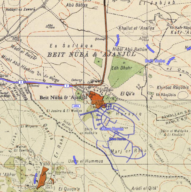
English: A 1940s map of Bayt Nuba from the Survey of Palestine overlaid with modern roads. This map is part of a series of historical maps used for comparison, showing the same area. Related files include:
|
||
| Data | 1870s, 1940s and 2020 | ||
| Fonte |
Sources for historical series of maps as follows: Overlay from Palestine Open Maps |
||
| Autore |
Sources for historical series of maps as follows: Overlay from Palestine Open Maps |
.jpg)
.jpg)
.jpg)
.jpg?uselang=it)
.jpg)
.jpg&action=edit)
| Luogo dello scatto | | Posizione di questa e altre immagini su: OpenStreetMap |
|---|
.jpg¶ms=031.853333_N_0035.032500_E_globe:Earth_type:camera__&language=it)
Licenza
Copyright for the OpenStreetMap data
| This work contains information from OpenStreetMap, which is made available under the Open Database License (ODbL).
The ODbL does not require any particular license for maps produced from ODbL data. Prior to 1 August 2020, map tiles produced by the OpenStreetMap Foundation were licensed under the CC-BY-SA-2.0 license. Maps produced by other people may be subject to other licences. |
Copyright for the Survey of Palestine and PEF Survey maps:
Quest'opera d'arte creata dal Governo del Regno Unito è nel pubblico dominio a causa di una delle seguenti motivazioni:
HMSO ha dichiarato che la cessazione del Crown copyright si applica in tutto il mondo (ref: HMSO Email Reply)
|
 |
This work was created or ordered by the State of Israel, and is in the public domain because it satisfies one of the conditions stipulated in Israel's copyright statute from 2007 (translation) regarding the State's copyrights:
|

|
Cronologia del file
Fare clic su un gruppo data/ora per vedere il file come si presentava nel momento indicato.
| Data/Ora | Miniatura | Dimensioni | Utente | Commento | |
|---|---|---|---|---|---|
| attuale | 09:42, 27 lug 2020 | | 739 × 742 (286 KB) | Onceinawhile | Uploaded a work by Sources for historical series of maps as follows: * PEF Survey of Palestine * Survey of Palestine Overlay from [https://palopenmaps.org Palestine Open Maps] * OpenStreetMap from Sources for historical series of maps as follows: * PEF Survey of Palestine * Survey of Palestine Overlay from [https://palopenmaps.org Palestine Open Maps] * [... |
Pagine che usano questo file
La seguente pagina usa questo file:
Utilizzo globale del file
Anche i seguenti wiki usano questo file:
- Usato nelle seguenti pagine di en.wikipedia.org:
Metadati
Questo file contiene informazioni aggiuntive, probabilmente aggiunte dalla fotocamera o dallo scanner usati per crearlo o digitalizzarlo. Se il file è stato modificato, alcuni dettagli potrebbero non corrispondere alla realtà.
| Descrizione dell'immagine |
|
|---|---|
| Latitudine | 31° 51′ 12″ N |
| Longitudine | 35° 1′ 57″ E |
| Risoluzione orizzontale | 1 punti per centimetro (dpc) |
| Risoluzione verticale | 1 punti per centimetro (dpc) |
| Posizionamento componenti Y e C | Centrato |
| Versione dei tag GPS | 2.3.0.0 |
.jpg&action=edit)
.jpg)