File:Fort Saint Anthony in Axim, Western Region, Ghana.jpg

File originale (4 032 × 3 024 pixel, dimensione del file: 4,4 MB, tipo MIME: image/jpeg)
| Questo file e la sua pagina di descrizione (discussione · modifica) si trovano su Wikimedia Commons (?) |
Dettagli
| Descrizione |
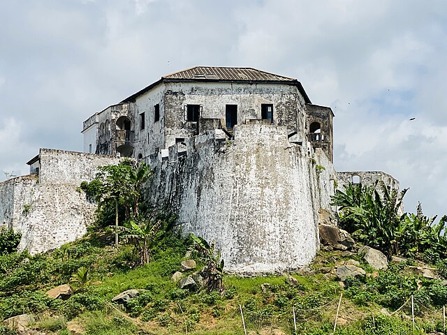
English: The history of Fort St. Anthony, located in Axim in the Western Region of Ghana, partly illustrates the motive for the construction of heavily fortified forts on natural elevations – especially on a rocky one that juts out into the sea.
In 1503, the Portuguese had built a trade post in Axim, near the edge of the River Ankobra, but they had to abandon it due to insistent attacks by the local people. They then constructed, in 1515, a massive triangular fort on a small promontory closer to the River Ankobra. Named ‘Santo Antonio’, it was the second Portuguese fort built on the Gold Coast, after St. George’s Castle (Elmina Castle). To enhance its defence on the landward side, a three-metre deep rock-cut trench was constructed. The effective defensive capability of Fort St. Anthony was revealed by its ability to withstand attacks for over four years, even after the fall of Elmina to the Dutch in 1637. Having no rival in the surrounding gold-rich lands of the Ankobra and Tano River valleys enhanced the economic viability of the fort; gold traders from Adanse and Denkyira frequently visited the fort. However, between 1670 and 1720, with the construction of rival forts in the bays east of Axim, Portuguese trade monopoly was ruined. By the 1720s, St. Anthony had become a Dutch fort. The fort is reported to have amassed ‘more gold at Axim than anywhere else together’ , especially after the dissolution of the Brandenburg Company and the death of John Conny (see Fort Gross Fredericksburg). The area was also an important source of timber and cotton for Dutch plantations. The fort was ceded to Britain in 1872. |
| Data | |
| Fonte | Opera propria |
| Autore | Jesuraj Alakassery |
Licenza
- Tu sei libero:
- di condividere – di copiare, distribuire e trasmettere quest'opera
- di modificare – di adattare l'opera
- Alle seguenti condizioni:
- attribuzione – Devi fornire i crediti appropriati, un collegamento alla licenza e indicare se sono state apportate modifiche. Puoi farlo in qualsiasi modo ragionevole, ma non in alcun modo che suggerisca che il licenziante approvi te o il tuo uso.
- condividi allo stesso modo – Se remixi, trasformi o sviluppi il materiale, devi distribuire i tuoi contributi in base alla stessa licenza o compatibile all'originale.
Cronologia del file
Fare clic su un gruppo data/ora per vedere il file come si presentava nel momento indicato.
| Data/Ora | Miniatura | Dimensioni | Utente | Commento | |
|---|---|---|---|---|---|
| attuale | 16:25, 3 feb 2023 | | 4 032 × 3 024 (4,4 MB) | Jesuraj Alakassery | Uploaded own work with UploadWizard |
Pagine che usano questo file
La seguente pagina usa questo file:
Utilizzo globale del file
Anche i seguenti wiki usano questo file:
- Usato nelle seguenti pagine di de.wikipedia.org:
- Usato nelle seguenti pagine di en.wikivoyage.org:
- Usato nelle seguenti pagine di fr.wikipedia.org:
- Usato nelle seguenti pagine di ha.wikipedia.org:
- Usato nelle seguenti pagine di he.wikipedia.org:
- Usato nelle seguenti pagine di www.wikidata.org: