File:Fort Laramie Treaty, 1851. Indian territories, Like A Fishhook Village, Oregon Trail and Santa Fe Trail.png
Vai alla navigazione
Vai alla ricerca

Dimensioni di questa anteprima: 534 × 599 pixel. Altre risoluzioni: 214 × 240 pixel | 428 × 480 pixel | 684 × 768 pixel | 1 243 × 1 395 pixel.
File originale (1 243 × 1 395 pixel, dimensione del file: 4,3 MB, tipo MIME: image/png)
| Questo file e la sua pagina di descrizione (discussione · modifica) si trovano su Wikimedia Commons (?) |
Dettagli
| Descrizione |
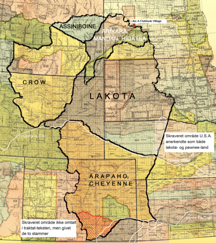
Dansk: Fort Laramie traktatens (1851) territorier for lakota-, cheyenne- og arapaho-, crow-, assiniboine- samt mandan-, hidatsa- og arikara-stammen. Endvidere Like A Fishhook Village, Oregon Trail, Santa Fe Trail samt området syd for Arkansas River tildelt cheyennerne- og arapahoerne p.g.a. en misforstået traktattekst (rød skravering). Også området anerkendt som både lakota- og pawnee-land af U.S.A. (hvid skravering).
English: The territories of the Lakota, Cheyenne and Arapaho, Crow, Assiniboine and Mandan, Hidatsa and Arikara tribes. Also Like A Fishhook Village, Oregon Trail and Santa Fe Trail. Further, the south area added to the territory of the Cheyenne and Arapaho due to a misunderstanding of the treaty text (red hatching) – (see ”Historical data and remarks”. U.S Serial Set, Number 4015, 56. Congress, 1. Session. P. 786.) Also the area recognized by the U.S. as territory of both the Lakota and the Pawnee (white hatching) - (See Blaine, Martha Royce: ”Pawnee Passage, 1870-1875.” Norman and London. 1990. P. 212. Also Royce, Charles C.: ”Indian Land Cessions in the United States.” Bureau of American Ethnology. Eighteenth Annual Report. Part 2. Washington, 1899. P. 819.) |
| Data | |
| Fonte | Royce, Charles C.: Indian Land Cessions in the United States. Bureau of American Ethnology. Eighteenth Annual Report. Part 2. Washington, 1899. GPO |
| Autore | Compiled by Charles C, Royce (original maps now adapted to written text) |
Licenza
| Questa opera proviene dalla Biblioteca del Congresso. Secondo la biblioteca, non esiste alcuna restrizione nota del diritto di copia sull'uso di quest'opera. |  |

|
This is a file uploaded through the Danish Wikipedia, which has not been reviewed on Commons:
|
Cronologia del file
Fare clic su un gruppo data/ora per vedere il file come si presentava nel momento indicato.
| Data/Ora | Miniatura | Dimensioni | Utente | Commento | |
|---|---|---|---|---|---|
| attuale | 11:02, 9 gen 2022 | | 1 243 × 1 395 (4,3 MB) | Indianertosset | Uploaded a work by Compiled by Charles C, Royce (original maps now adapted to written text) from Royce, Charles C.: Indian Land Cessions in the United States. Bureau of American Ethnology. Eighteenth Annual Report. Part 2. Washington, 1899. GPO with UploadWizard |
Pagine che usano questo file
La seguente pagina usa questo file:
Utilizzo globale del file
Anche i seguenti wiki usano questo file:
- Usato nelle seguenti pagine di da.wikipedia.org: