File:Esteros del Iberá.jpg
Vai alla navigazione
Vai alla ricerca
Dimensioni di questa anteprima: 800 × 530 pixel. Altre risoluzioni: 320 × 212 pixel | 640 × 424 pixel | 1 024 × 678 pixel | 1 280 × 847 pixel | 2 183 × 1 445 pixel.
File originale (2 183 × 1 445 pixel, dimensione del file: 1 MB, tipo MIME: image/jpeg)
| Questo file e la sua pagina di descrizione (discussione · modifica) si trovano su Wikimedia Commons (?) |
Dettagli
| Descrizione |
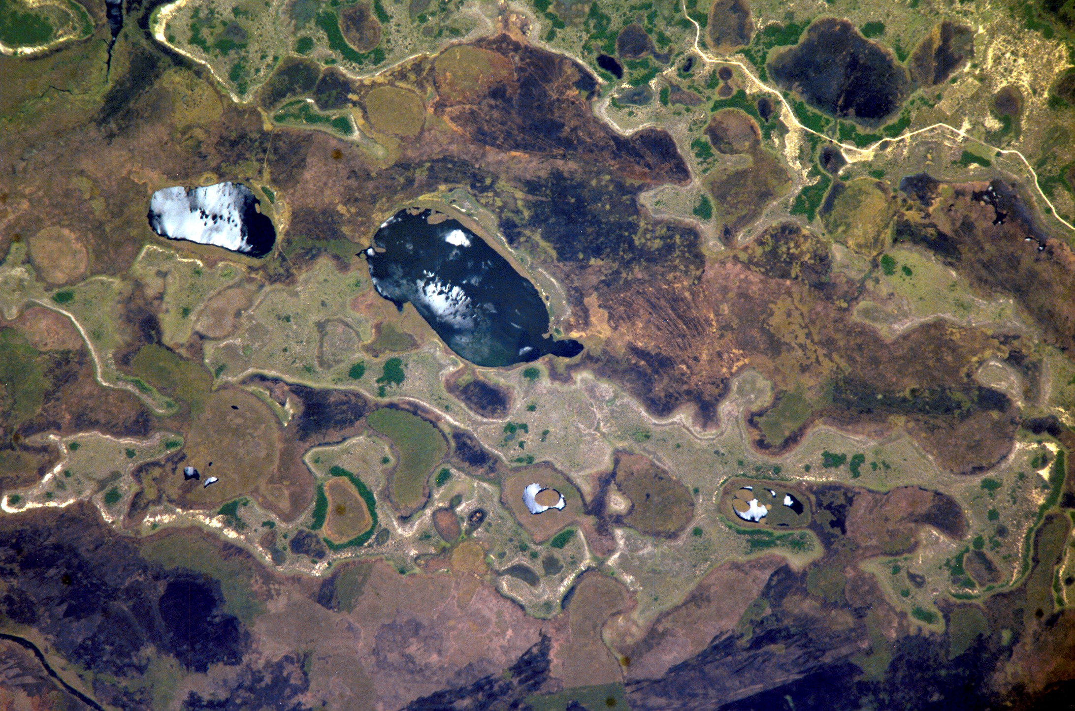
English: Ibera Wetlands, province of Corrientes, Argentina, one of the largest wetland areas in South America (the second largest after Brazil's Pantanal). Picture taken from the International Space Station.
Español: Esteros del Iberá, provincia de Corrientes, Argentina, uno de los más grandes humedales de Sudamérica (el segundo en tamaño después del Pantanal en Brasil). Foto tomada desde la Estación Espacial Internacional. |
| Data | Scattata il 25 ottobre 2004 |
| Fonte | http://spaceflight.nasa.gov/gallery/images/station/crew-10/html/iss010e05072.html |
| Autore | NASA |
Questa immagine o filmato è stato catalogato dal Johnson Space Center della National Aeronautics and Space Administration (NASA) degli Stati Uniti d'Americacon il Photo ID: ISS010-E-05072.Questo tag non indica lo status del copyright dell'opera ad esso associato. È quindi richiesto un normale tag di copyright. Vedi Commons:Licenze per maggiori informazioni. Altre lingue:
|
Licenza
"The Gateway to Astronaut Photography of Earth". Le immagini provengono dall'Image Science & Analysis Laboratory, della NASA Johnson Space Center.
Fonte della foto: ISS010-E-05072.
|
Cronologia del file
Fare clic su un gruppo data/ora per vedere il file come si presentava nel momento indicato.
| Data/Ora | Miniatura | Dimensioni | Utente | Commento | |
|---|---|---|---|---|---|
| attuale | 22:02, 26 dic 2017 | | 2 183 × 1 445 (1 MB) | Ras67 | high resolution |
| 12:12, 10 feb 2006 |  | 640 × 423 (118 KB) | Pablo-flores | '''es:''' Esteros del Iberá, provincia de Corrientes, Argentina, uno de los más grandes humedales de Sudamérica (el segundo en tamaño después del Pantanal en Brasil). Foto tomada desde la Estación Espacial Internacional. '''en:''' Ibera Wetland |
Pagine che usano questo file
La seguente pagina usa questo file:
Utilizzo globale del file
Anche i seguenti wiki usano questo file:
- Usato nelle seguenti pagine di bs.wikipedia.org:
- Usato nelle seguenti pagine di de.wikipedia.org:
- Usato nelle seguenti pagine di en.wikipedia.org:
- Usato nelle seguenti pagine di eo.wikipedia.org:
- Usato nelle seguenti pagine di es.wikipedia.org:
- Usato nelle seguenti pagine di eu.wikipedia.org:
- Usato nelle seguenti pagine di fr.wikipedia.org:
- Usato nelle seguenti pagine di no.wikipedia.org:
- Usato nelle seguenti pagine di pt.wikipedia.org:
- Usato nelle seguenti pagine di zh.wikipedia.org: