File:Dean Architects - fmr Railway Branch YMCA - Depew, New York - 20210219.jpg
Vai alla navigazione
Vai alla ricerca

Dimensioni di questa anteprima: 800 × 599 pixel. Altre risoluzioni: 320 × 240 pixel | 640 × 480 pixel | 1 024 × 767 pixel | 1 280 × 959 pixel | 1 791 × 1 342 pixel.
File originale (1 791 × 1 342 pixel, dimensione del file: 833 KB, tipo MIME: image/jpeg)
| Questo file e la sua pagina di descrizione (discussione · modifica) si trovano su Wikimedia Commons (?) |
Dettagli
| Descrizione |
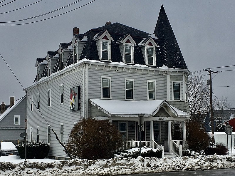
English: Dean Architects, 3284 Walden Avenue at Tyler Street, Depew, New York, February 2021. Erected in 1896 as one of the first batch of institutional buildings built by the Depew Improvement Company for the then-newly founded village, this serves as an anachronistic example of the Second Empire architectural style with its bracketed cornice, pedimented dormer windows framed by stylized columns, and of course, proud mansard roof. However, the shingle-sided, tent-roofed corner turret and the asymmetrical front porch with its off-center pediment both borrow from the Queen Anne style, which was much less passé at the time. The building functioned initially as the so-called Railroad Branch YMCA, which appears to have been defunct by 1912: a Depew Herald article from that year mentions a proposal to move the "former Y.M.C.A. building" to nearby Transit Road and convert it to a hotel, which apparently never materialized as the building remains on its original site. By 1939 it was in use as apartments, initially with a modest but respectable lower-middle-class tenant base composed mainly of workers at the machine shops and factories gathered around the New York Central Railroad line; the village's raison d'être. By the 1980s it had degenerated into a sleazy and dilapidated rooming house, and it was slated for demolition by 1998, when DeanSutton Architecture purchased the building and fully restored it for use as their offices. Dean Architects, the successor firm, remains headquartered there today. |
| Data | Scattata il 19 febbraio 2021, 10:43:48 |
| Fonte | Opera propria |
| Autore | Andre Carrotflower |
| Luogo dello scatto | | Posizione di questa e altre immagini su: OpenStreetMap |
|---|
Licenza
Io, detentore del copyright su quest'opera, dichiaro di pubblicarla con la seguente licenza:
Questo file è disponibile in base alla licenza Creative Commons Attribuzione-Condividi allo stesso modo 4.0 Internazionale
- Tu sei libero:
- di condividere – di copiare, distribuire e trasmettere quest'opera
- di modificare – di adattare l'opera
- Alle seguenti condizioni:
- attribuzione – Devi fornire i crediti appropriati, un collegamento alla licenza e indicare se sono state apportate modifiche. Puoi farlo in qualsiasi modo ragionevole, ma non in alcun modo che suggerisca che il licenziante approvi te o il tuo uso.
- condividi allo stesso modo – Se remixi, trasformi o sviluppi il materiale, devi distribuire i tuoi contributi in base alla stessa licenza o compatibile all'originale.
Cronologia del file
Fare clic su un gruppo data/ora per vedere il file come si presentava nel momento indicato.
| Data/Ora | Miniatura | Dimensioni | Utente | Commento | |
|---|---|---|---|---|---|
| attuale | 05:34, 25 apr 2021 | | 1 791 × 1 342 (833 KB) | Andre Carrotflower | Uploaded own work with UploadWizard |
Pagine che usano questo file
La seguente pagina usa questo file:
Utilizzo globale del file
Anche i seguenti wiki usano questo file:
- Usato nelle seguenti pagine di ar.wikipedia.org:
- Usato nelle seguenti pagine di ca.wikipedia.org:
- Usato nelle seguenti pagine di ceb.wikipedia.org:
- Usato nelle seguenti pagine di cy.wikipedia.org:
- Usato nelle seguenti pagine di es.wikipedia.org:
- Usato nelle seguenti pagine di eu.wikipedia.org:
- Usato nelle seguenti pagine di fr.wikipedia.org:
- Usato nelle seguenti pagine di ht.wikipedia.org:
- Usato nelle seguenti pagine di hu.wikipedia.org:
- Usato nelle seguenti pagine di lld.wikipedia.org:
- Usato nelle seguenti pagine di pl.wikipedia.org:
- Usato nelle seguenti pagine di sr.wikipedia.org:
- Usato nelle seguenti pagine di uk.wikipedia.org:
- Usato nelle seguenti pagine di www.wikidata.org: